Massachusetts Archives
Massachusetts Metropolitan District Water Supply Commission, Quabbin Reservoir, Photographs of Real Estate, Sanitary Conditions, and Flooding in the Ware River Watershed, and of General Engineering, 1928-1948
In order to improve the water supply to the greater Boston metropolitan area, the Metropolitan District Water Supply Commission was authorized to take property in the watersheds of the Swift and Ware rivers to develop what became the Quabbin Reservoir. These photographs, largely taken between 1928 and the early 1940s, depict factories and mills, and their tenements, churches, cemeteries, schoolhouses, general stores, railroad stations, homes, barns, chicken houses, a prison camp, seasonal dwellings (including camps) along lakes and ponds, and brooks and rivers.
After years of engineering study and debate, the Commonwealth created the Metropolitan District Water Supply Commission (MDWSC) to build an improved water supply reservoir and system to serve metropolitan Boston, in the valley of the Swift River, a tributary of the Connecticut River. The Ware River Act (St. 1926, c. 375) and the later Swift River Act (St. 1927, c. 321) directed the floodwaters of the Ware River to be diverted, and the Swift River Valley dammed and flooded for a new water supply reservoir. Known as the Swift River Reservoir from 1926-1932, the MDWSC officially renamed it the Quabbin Reservoir on October 25, 1932. The word "Quabbin" is from the Nipmuck, the Native American tribe that historically inhabited the valley, which roughly translates to "the place or the meeting of many waters."
A vital component of the Quabbin Reservoir project was the "sanitary protection," for water supply purposes, of the Ware River Watershed, specifically the upper watershed, from the village of Coldbrook, Barre, and above, as floodwaters from the upper watershed are diverted through the Quabbin Aqueduct (at the Ware River Intake and Diversion Works), westward, into the Quabbin Reservoir. The upper Ware Water Watershed consists of 96.8 square miles, and contains nearly all of the town of Hubbardston, the greater part of Rutland, parts of Barre, Phillipston and Templeton, and lesser parts of Oakham, Princeton and Westminster. The MDWSC purchased real estate in these towns for sanitary protection.
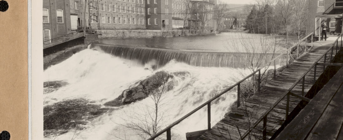
Additionally, the taking of water rights in the Ware and Swift Rivers, and its tributaries, would impact the extensive manufacturing industries along the lower Ware River, and Chicopee River, to which the Ware and Swift flow into. At the time, these industries had extensive hydroelectric dams and water power plants along these rivers, in addition to there being smaller mills and their mill dams. The MDWSC studied the flow of water, and established stream gages along them to take measurements. Some manufacturing companies sued the MDWSC for the taking of these water rights, and the MDWSC paid compensation due to diversion damages.
Because the Quabbin Reservoir project included the taking of floodwaters from the upper Ware River Watershed, the MDWSC engineers studied the flow of "high water" through the Ware and Chicopee Rivers, and its tributaries of brooks after the 1931 completion of the Quabbin Aqueduct and its facilities.
Throughout New England in the late 1920s and 1930s, there were periodic floods. Two record-setting floods, in March 1936 and in September 1938, during the Hurricane of 1938, significantly impacted the Ware and Chicopee Rivers, and the towns and industries along them.
The MDWSC engineers also studied the wastes that flowed into ponds and lakes, and into brooks and rivers, from residential structures, summer camps, state hospitals and prisons, and from industry throughout the Ware River Watershed. They took water samples, which were analyzed in the Commission's Chemical Laboratory.
The first diversion of floodwater from the upper Water River Watershed was made on March 20, 1931 (eastward, through the Quabbin Aqueduct, into the Wachusett Reservoir). The first flow of water from the Quabbin Reservoir into the Wachusett Reservoir was made on September 17, 1941.
All of these subjects are photographically documented in this specific photograph collection. This collection consists of 1,923 photographic prints (5"x7"), and 64 original negatives (5"x7") for photo prints that do not survive. The MDWSC employed engineering photographers to document these subjects. The buildings and structures of about 21 manufacturing factories are documented in these photos (including some interior views), along with damage incurred from the 1936 and 1938 floods. Flood damage in the town of Ware, along the Ware River, is documented from the September 1938 flood and hurricane.
Per the Acts of 1947, chapter 583, the MDWSC was abolished, and the operation of the Quabbin Reservoir, upper Ware River Watershed and its associated aqueduct and facilities, was transferred to the Metropolitan District Commission (MDC), Water Division (1919-1985), Quabbin Section. In 1985, the operations of the MDC Water Division were divided between two new entities: the MDC, Division of Watershed Management (1985-2003), and the Massachusetts Water Resources Authority. Since 2003, Quabbin Reservoir and its upper Ware River Watershed are managed by the Department of Conservation and Recreation, Division of Water Supply Protection, Office of Watershed Management, Quabbin Region.
The photographic prints in this specific set were backed with linen cloth (and stamped in red with the MDWSC name and Boston mailing address on back) and were bound in 39 numbered volumes, 50 prints per volume (2-hole punched, bound with brass fasteners), numbered from 1 to 1921. Multiple official and reference sets were created (a "Secretary" set, a "Chief Engineer" set, etc.) with some set volumes now lost. In the frame of each real estate photograph is a chalkboard, indicating various real estate information and the date. The photos have a caption along the bottom (called ‘titling' by the photographers) with changing formats, with the photographer's last name nearly always stated. The photographic prints were annotated by the MDWSC with property sale information.
See also,
Massachusetts Metropolitan District Water Supply Commission, Quabbin Reservoir, Photographs of Real Estate in the Swift River Valley, and of General Engineering of Quabbin Reservoir, 1927-1950
https://www.digitalcommonwealth.org/collections/commonwealth:qr46sf05h
Massachusetts Metropolitan District Water Supply Commission, Quabbin Reservoir, Photographs of Cemeteries, 1928-1945
https://www.digitalcommonwealth.org/collections/commonwealth:76537133j
The digital access project was led jointly by the Massachusetts Department of Conservation and Recreation (Archives) and the Massachusetts Water Resources Authority (Library), co-operators of the water supply system for greater Boston, and in cooperation with the Massachusetts Archives, and the Department of Conservation and Recreation, Division of Water Supply Protection, Office of Watershed Management.
After years of engineering study and debate, the Commonwealth created the Metropolitan District Water Supply Commission (MDWSC) to build an improved water supply reservoir and system to serve metropolitan Boston, in the valley of the Swift River, a tributary of the Connecticut River. The Ware River Act (St. 1926, c. 375) and the later Swift River Act (St. 1927, c. 321) directed the floodwaters of the Ware River to be diverted, and the Swift River Valley dammed and flooded for a new water supply reservoir. Known as the Swift River Reservoir from 1926-1932, the MDWSC officially renamed it the Quabbin Reservoir on October 25, 1932. The word "Quabbin" is from the Nipmuck, the Native American tribe that historically inhabited the valley, which roughly translates to "the place or the meeting of many waters."
A vital component of the Quabbin Reservoir project was the "sanitary protection," for water supply purposes, of the Ware River Watershed, specifically the upper watershed, from the village of Coldbrook, Barre, and above, as floodwaters from the upper watershed are diverted through the Quabbin Aqueduct (at the Ware River Intake and Diversion Works), westward, into the Quabbin Reservoir. The upper Ware Water Watershed consists of 96.8 square miles, and contains nearly all of the town of Hubbardston, the greater part of Rutland, parts of Barre, Phillipston and Templeton, and lesser parts of Oakham, Princeton and Westminster. The MDWSC purchased real estate in these towns for sanitary protection.
Additionally, the taking of water rights in the Ware and Swift Rivers, and its tributaries, would impact the extensive manufacturing industries along the lower Ware River, and Chicopee River, to which the Ware and Swift flow into. At the time, these industries had extensive hydroelectric dams and water power plants along these rivers, in addition to there being smaller mills and their mill dams. The MDWSC studied the flow of water, and established stream gages along them to take measurements. Some manufacturing companies sued the MDWSC for the taking of these water rights, and the MDWSC paid compensation due to diversion damages.
Because the Quabbin Reservoir project included the taking of floodwaters from the upper Ware River Watershed, the MDWSC engineers studied the flow of "high water" through the Ware and Chicopee Rivers, and its tributaries of brooks after the 1931 completion of the Quabbin Aqueduct and its facilities.
Throughout New England in the late 1920s and 1930s, there were periodic floods. Two record-setting floods, in March 1936 and in September 1938, during the Hurricane of 1938, significantly impacted the Ware and Chicopee Rivers, and the towns and industries along them.
The MDWSC engineers also studied the wastes that flowed into ponds and lakes, and into brooks and rivers, from residential structures, summer camps, state hospitals and prisons, and from industry throughout the Ware River Watershed. They took water samples, which were analyzed in the Commission's Chemical Laboratory.
The first diversion of floodwater from the upper Water River Watershed was made on March 20, 1931 (eastward, through the Quabbin Aqueduct, into the Wachusett Reservoir). The first flow of water from the Quabbin Reservoir into the Wachusett Reservoir was made on September 17, 1941.
All of these subjects are photographically documented in this specific photograph collection. This collection consists of 1,923 photographic prints (5"x7"), and 64 original negatives (5"x7") for photo prints that do not survive. The MDWSC employed engineering photographers to document these subjects. The buildings and structures of about 21 manufacturing factories are documented in these photos (including some interior views), along with damage incurred from the 1936 and 1938 floods. Flood damage in the town of Ware, along the Ware River, is documented from the September 1938 flood and hurricane.
Per the Acts of 1947, chapter 583, the MDWSC was abolished, and the operation of the Quabbin Reservoir, upper Ware River Watershed and its associated aqueduct and facilities, was transferred to the Metropolitan District Commission (MDC), Water Division (1919-1985), Quabbin Section. In 1985, the operations of the MDC Water Division were divided between two new entities: the MDC, Division of Watershed Management (1985-2003), and the Massachusetts Water Resources Authority. Since 2003, Quabbin Reservoir and its upper Ware River Watershed are managed by the Department of Conservation and Recreation, Division of Water Supply Protection, Office of Watershed Management, Quabbin Region.
The photographic prints in this specific set were backed with linen cloth (and stamped in red with the MDWSC name and Boston mailing address on back) and were bound in 39 numbered volumes, 50 prints per volume (2-hole punched, bound with brass fasteners), numbered from 1 to 1921. Multiple official and reference sets were created (a "Secretary" set, a "Chief Engineer" set, etc.) with some set volumes now lost. In the frame of each real estate photograph is a chalkboard, indicating various real estate information and the date. The photos have a caption along the bottom (called ‘titling' by the photographers) with changing formats, with the photographer's last name nearly always stated. The photographic prints were annotated by the MDWSC with property sale information.
See also,
Massachusetts Metropolitan District Water Supply Commission, Quabbin Reservoir, Photographs of Real Estate in the Swift River Valley, and of General Engineering of Quabbin Reservoir, 1927-1950
https://www.digitalcommonwealth.org/collections/commonwealth:qr46sf05h
Massachusetts Metropolitan District Water Supply Commission, Quabbin Reservoir, Photographs of Cemeteries, 1928-1945
https://www.digitalcommonwealth.org/collections/commonwealth:76537133j
The digital access project was led jointly by the Massachusetts Department of Conservation and Recreation (Archives) and the Massachusetts Water Resources Authority (Library), co-operators of the water supply system for greater Boston, and in cooperation with the Massachusetts Archives, and the Department of Conservation and Recreation, Division of Water Supply Protection, Office of Watershed Management.