21. Boston Highlands, Massachusetts : Wards 19, 20, 21 & 22 of Boston Creator: O.H. Bailey & Co Format: Maps/Atlases Collection: Boston and New England Maps (Collection of Distinction) / Norman B. Leventhal Map & Education Center Collection / Urban Maps (Collection of Distinction) Date: [1888] Institution: Boston Public Library
22. Boston proper Format: Maps/Atlases Collection: Boston Redevelopment Authority Collection / Boston and New England Maps (Collection of Distinction) / Norman B. Leventhal Map & Education Center Collection / Urban Maps (Collection of Distinction) Date: [1965] Institution: Boston Public Library
23. The city of Boston : 1879 Creator: Hazen, J. C. Format: Maps/Atlases; Manuscripts Collection: Boston and New England Maps (Collection of Distinction) / Norman B. Leventhal Map & Education Center Collection / Urban Maps (Collection of Distinction) Date: 1879 Institution: Boston Public Library
24. The City of Boston : 1879 Creator: O.H. Bailey & Co, O.H. Bailey & Co, and Armstrong & Co. (Boston, Mass.) Format: Maps/Atlases Collection: Boston and New England Maps (Collection of Distinction) / Norman B. Leventhal Map & Education Center Collection / Urban Maps (Collection of Distinction) Date: 1879 Institution: Boston Public Library
25. The City of Boston : 1879 Creator: O.H. Bailey & Co, O.H. Bailey & Co, and Armstrong & Co. (Boston, Mass.) Format: Maps/Atlases Collection: Boston and New England Maps (Collection of Distinction) / Norman B. Leventhal Map & Education Center Collection / Urban Maps (Collection of Distinction) Date: 1879 Institution: Boston Public Library
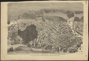
26. The city of Boston Creator: Parsons & Atwater Format: Maps/Atlases Collection: Boston and New England Maps (Collection of Distinction) / Norman B. Leventhal Map & Education Center Collection / Urban Maps (Collection of Distinction) Date: 1873 Institution: Boston Public Library
27. The embankment and park on Charles River Bay Creator: Davenport, Charles. Format: Maps/Atlases Collection: Boston and New England Maps (Collection of Distinction) / Norman B. Leventhal Map & Education Center Collection / Urban Maps (Collection of Distinction) Date: [1886] Institution: Boston Public Library
28. Environs of Boston, from Corey's Hill, Brookline, Mass Creator: Richardson, Freeman. Format: Maps/Atlases Collection: Boston and New England Maps (Collection of Distinction) / Norman B. Leventhal Map & Education Center Collection / Urban Maps (Collection of Distinction) Date: 1864 Institution: Boston Public Library
29. General unsicht von Boston and der Bogelschau mit Bezeichnung des abgebrannten Stadttheiles : = Bird's eye view of Boston, showing the burned district Creator: Parsons, Charles R. (Charles Richard), 1844-1918 Format: Maps/Atlases Collection: Boston and New England Maps (Collection of Distinction) / Norman B. Leventhal Map & Education Center Collection / Urban Maps (Collection of Distinction) Date: [1872] Institution: Boston Public Library
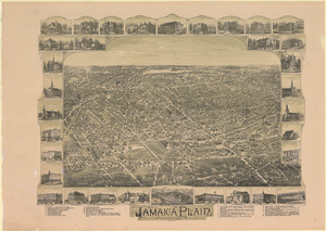
30. Jamaica Plain, Massachusetts : Ward 23, City of Boston, 1891 Creator: O.H. Bailey & Co Format: Maps/Atlases Collection: Boston and New England Maps (Collection of Distinction) / Norman B. Leventhal Map & Education Center Collection / Urban Maps (Collection of Distinction) Date: 1891 Institution: Boston Public Library
31. Mattapan, Massachusetts, 1890 Creator: O.H. Bailey & Co Format: Maps/Atlases Collection: Boston and New England Maps (Collection of Distinction) / Norman B. Leventhal Map & Education Center Collection / Urban Maps (Collection of Distinction) Date: 1890 Institution: Boston Public Library
32. New Boston and Charles River Bay Format: Maps/Atlases Collection: Boston and New England Maps (Collection of Distinction) / Norman B. Leventhal Map & Education Center Collection / Urban Maps (Collection of Distinction) Date: [1886] Institution: Boston Public Library
33. Outline key to Richardson's view of the environs of Boston from Corey's Hill, Brookline Creator: Richardson, Freeman Format: Maps/Atlases Collection: Boston and New England Maps (Collection of Distinction) / Norman B. Leventhal Map & Education Center Collection / Urban Maps (Collection of Distinction) Date: 1865 Institution: Boston Public Library
34. Panoramic view from Bunker Hill Monument Creator: Mallory, Richard P.; Smillie, James Format: Maps/Atlases Collection: Boston and New England Maps (Collection of Distinction) / Norman B. Leventhal Map & Education Center Collection / Urban Maps (Collection of Distinction) Date: 1848 Institution: Boston Public Library
35. Perspective view of Bunker Hill Monument Creator: Mallory, Richard P.; Fowle, Edward A. Format: Maps/Atlases Collection: Boston and New England Maps (Collection of Distinction) / Norman B. Leventhal Map & Education Center Collection / Urban Maps (Collection of Distinction) Date: 1848 Institution: Boston Public Library
36. A Scott-Map of Boston, Massachusetts Creator: Garfield, Alva Scott Format: Maps/Atlases Collection: Norman B. Leventhal Map & Education Center Collection Date: [ca. 1950] Institution: Boston Public Library
37. Twentieth century Boston Creator: Poole, A. F. Format: Maps/Atlases Collection: Norman B. Leventhal Map & Education Center Collection Date: [ca. 1905] Institution: Boston Public Library
38. View of Boston, July 4th 1870 Creator: Fuchs, F. Format: Maps/Atlases Collection: Boston and New England Maps (Collection of Distinction) / Norman B. Leventhal Map & Education Center Collection / Urban Maps (Collection of Distinction) Date: 1870 Institution: Boston Public Library
39. Boston Harbor : challenges and opportunities for the 1980's Creator: Boston Redevelopment Authority Format: Maps/Atlases Collection: Boston Redevelopment Authority Collection / Boston and New England Maps (Collection of Distinction) / Urban Maps (Collection of Distinction) Date: [ca. 1979] Institution: Boston Public Library
40. Jamaica Plain, Massachusetts: Ward 2, city of Boston Format: Maps/Atlases Collection: Other Date: 1890 Institution: State Library of Massachusetts