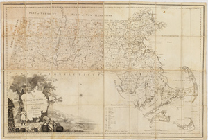
Map of Massachusetts Proper. Compiled from Actual Surveys made by Order of the General Court and under the inspection of Agents of their appointment.
Description:
This map, published in 1802, is the second edition of the first official map of Massachusetts entitied, Map of Massachusetts Proper, originally published in 1801. The idea for a state map began to take shape in 1791 when Osgood Carleton, one of the first professional mapmakers in America, suggested a regional map of Southern New England based on town surveys. The Massachusetts Historical Society supported the idea and helped persuade the Massachusetts General Court (the state legislature) to pass a state mapping law in 1794. Osgood Carleton produced the original design of the state map using information gathered from town surveys and information supplied by the Massachusetts Historical Society. Boston: B. J. Loring, 1802
Item from the collections of the Massachusetts Historical Society. Image use and licensing information: www.masshist.org/library/permissions
Contact host institution for more information.