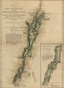
A Survey of Lake Champlain,including Lake George, Crown Point, and St. John. Surveyed by order of His Excellency Major-General Sr. Jeffery Amherst, Knight of the most Honble. Order of the Bath, Commander in Chief of His Majesty’s forces in North America
A Survey of Lake Champlain,including Lake George, Crown Point, and St. John. Surveyed by order of His Excellency Major-General Sr. Jeffery Amherst, Knight of the most Honble. Order of the Bath, Commander in Chief of His Majesty’s forces in North America
Description:
This map, from Atlas des colonies Angloises en Amerique, shows the area around Lake Champlain, which divides New York from Vermont. In 1755, the governor of Canada ordered the construction of Fort Carillon (Ticonderoga) at the place where travelers had to move overland between Lake Champlain and Lake George. Sir William Johnson responded by erecting Fort William Henry at the southern tip of Lake George. From Atlas des colonies Angloises en Amerique Title of inset map: "A Particular Plan of Lake George. Surveyed in 1756. By Capt. Jackson"
Item from the collections of the Massachusetts Historical Society. Image use and licensing information: www.masshist.org/library/permissions
Contact host institution for more information.