Skip to search
Skip to main content
Digital Commonwealth
Sign Up / Log In
Search for
Search
Search
Search
Basic
Advanced
Explore
Map
Collections
Institutions
Formats
For Educators
Primary Source Sets
Lesson Plans
Using Primary Sources
Searching Digital Commonwealth
For Institutions
Join Digital Commonwealth
Conferences, Trainings, & Events
How to Contribute Collections
Digitization Services
Board & Committees
Frequently Asked Questions
About
About Digital Commonwealth
News & Announcements
Copyright & Terms of Use
Harmful Content Statement
Partners
API
Contact Us
Boston Public Library
Norman B. Leventhal Map & Education Center Collection
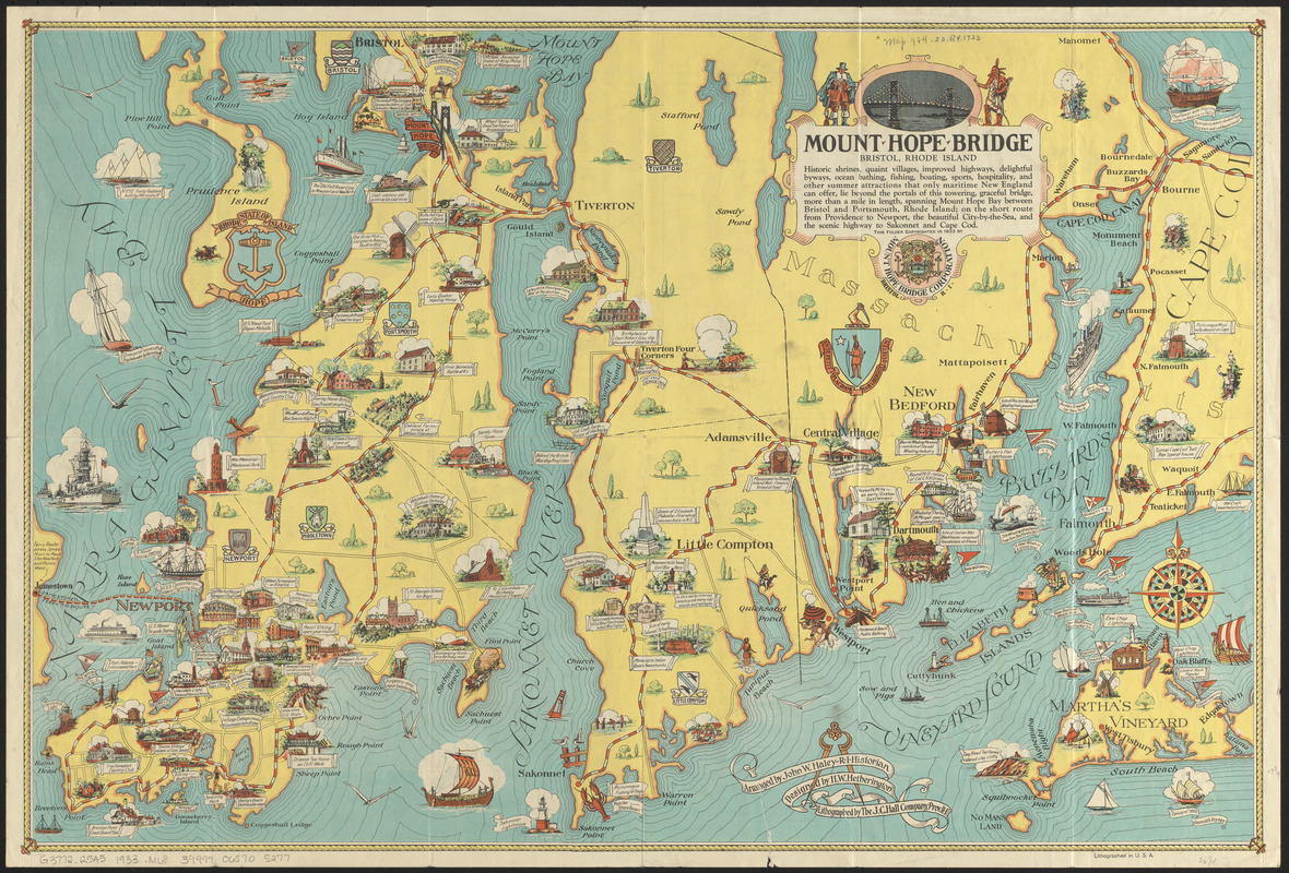
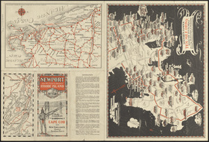
Mount Hope Bridge, Bristol, Rhode Island
Viewing image 1 of 2
Next >
Mount Hope Bridge, Bristol, Rhode Island
×
Next
Item Information
Title:
Mount Hope Bridge, Bristol, Rhode Island
Title (alt.):
Newport and the historic island of Rhode Island : on the scenic route to Sakonnet, Cape Cod and New England's greatest seashore resorts
Publisher:
Mount Hope Bridge Corporation (Bristol, R.I.)
Contributor:
Haley, John W.
Artist:
Hetherington, Herbert W.
Lithographer:
J.C. Hall Company
Name on Item:
arranged by John W. Haley, R.I. historian ; designed by H.W. Hetherington ; lithographed by the J.C. Hall Company
Date:
1933
Format:
Maps/Atlases
Location:
Boston Public Library
Norman B. Leventhal Map & Education Center
Collection (local):
Norman B. Leventhal Map & Education Center Collection
Subjects:
Newport (R.I.)--History--Maps
Rhode Island (R.I. : Island)--History--Maps
Newport County (R.I.)--History--Maps
Places:
Rhode Island
>
Newport (county)
>
Newport
Extent:
4 maps on 1 sheet : both sides, color ; sheet 45 x 67 cm, folded to 23 x 12 cm
Permalink:
https://ark.digitalcommonwealth.org/ark:/50959/0r96fm85j
Terms of Use:
No known copyright restrictions.
No known restrictions on use.
Publisher:
Bristol, R.I. : Mount Hope Bridge Corporation
Scale:
Not drawn to scale
Language:
English
Notes:
Includes illustrations of points of interest.
Text and 3 maps on verso.
Maps on verso: Newport's famous ten mile drive along the ocean front -- [Narragansett Bay area] -- [Southern New England].
Identifier:
06_01_014769
06_01_016190
Call #:
G3772.R5A5 1933 .M68
Barcode:
39999065705277
show more...
View MODS XML
More Like This
The 100th anniversary map of Abraham Lincoln's visit to ...
1630 shoreline
1879. Progress map of the U.S. Geographical Surveys west of the ...
1903 Map of Salem and surrounding places
Find More Like This >>
Tools
Share
Facebook
Pinterest
X
Reddit
Tumblr
Email
Copy link
Add to Folder
Questions/Comments
Cite This Item
IIIF Manifest
Downloads
Primary (full resolution, uncompressed)
(TIF, multi-file ZIP, 120 MB)
Large (full resolution)
(JPEG, multi-file ZIP, 1.06 MB)
Medium
(JPEG, multi-file ZIP, 1020 KB)