Skip to search
Skip to main content
Digital Commonwealth
Sign Up / Log In
Search for
Search
Search
Search
Basic
Advanced
Explore
Map
Collections
Institutions
Formats
For Educators
Primary Source Sets
Lesson Plans
Using Primary Sources
Searching Digital Commonwealth
For Institutions
Join Digital Commonwealth
Conferences, Trainings, & Events
How to Contribute Collections
Digitization Services
Board & Committees
Frequently Asked Questions
About
About Digital Commonwealth
News & Announcements
Copyright & Terms of Use
Harmful Content Statement
Partners
API
Contact Us
Boston Public Library
Norman B. Leventhal Map & Education Center Collection
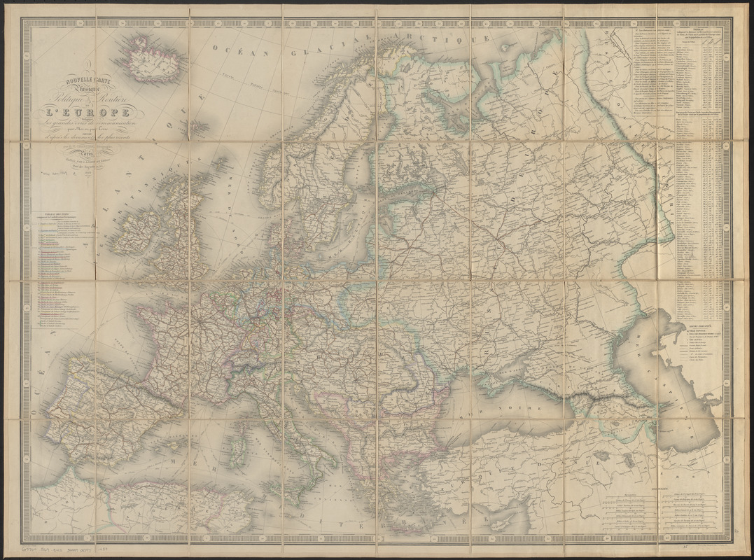
Nouvelle carte physique, politique & routière de l'Europe : indiquant les grandes voies de communication par mer et par terre
Nouvelle carte physique, politique & routière de lEurope
×
Item Information
Title:
Nouvelle carte physique, politique & routière de l'Europe : indiquant les grandes voies de communication par mer et par terre
Title (alt.):
Carte routière des chemins de fer de l'Europe a l'usage des voyageurs
Cartographer:
Chartier, A. T.
Publisher:
Logerot, A. (Auguste)
Printer:
Mangeon
Name on Item:
dressée d'après les documents les plus récents par A.T. Chartier, géographe ; gravée par Smith
Date:
1867
Format:
Maps/Atlases
Location:
Boston Public Library
Norman B. Leventhal Map & Education Center
Collection (local):
Norman B. Leventhal Map & Education Center Collection
Subjects:
Europe--Maps
Places:
Europe
Europe
Extent:
1 map : hand color ; 64 x 87 cm, folded in cover 19 x 13 cm
Permalink:
https://ark.digitalcommonwealth.org/ark:/50959/0z709527n
Terms of Use:
No known copyright restrictions.
No known restrictions on use.
Publisher:
Paris ; Paris : publi{acute}ee par A. Logerot, editeur ; Imp. Mangeon
Scale:
Scale approximately 1:6,625,000
Language:
French
Notes:
Relief shown by hachures.
Prime meridian: [Paris].
Includes table of German states, table of distances and note about distances.
Identifier:
06_01_016717
Call #:
G5700 1869 .C43
Barcode:
39999085951489
show more...
View MODS XML
More Like This
An accurate map of Europe from the best authorities
Angling in troubled waters = der fischfang im truben = la peche en ...
Bacon's large scale shilling map of seat of war from Paris to ...
Bacon's map of Europe
Find More Like This >>
Tools
Share
Facebook
Pinterest
X
Reddit
Tumblr
Email
Copy link
Add to Folder
Questions/Comments
Cite This Item
IIIF Manifest
Downloads
Primary (full resolution, uncompressed)
(TIF, 111 MB)
Large (full resolution)
(JPEG, 9.34 MB)
Medium
(JPEG, 385 KB)