Skip to search
Skip to main content
Digital Commonwealth
Sign Up / Log In
Search for
Search
Search
Search
Basic
Advanced
Explore
Map
Collections
Institutions
Formats
For Educators
Primary Source Sets
Lesson Plans
Using Primary Sources
Searching Digital Commonwealth
For Institutions
Join Digital Commonwealth
Conferences, Trainings, & Events
How to Contribute Collections
Digitization Services
Board & Committees
Frequently Asked Questions
About
About Digital Commonwealth
News & Announcements
Copyright & Terms of Use
Harmful Content Statement
Partners
API
Contact Us
Boston Public Library
Norman B. Leventhal Map & Education Center Collection
/
Maritime Charts and Atlases (Collection of Distinction)
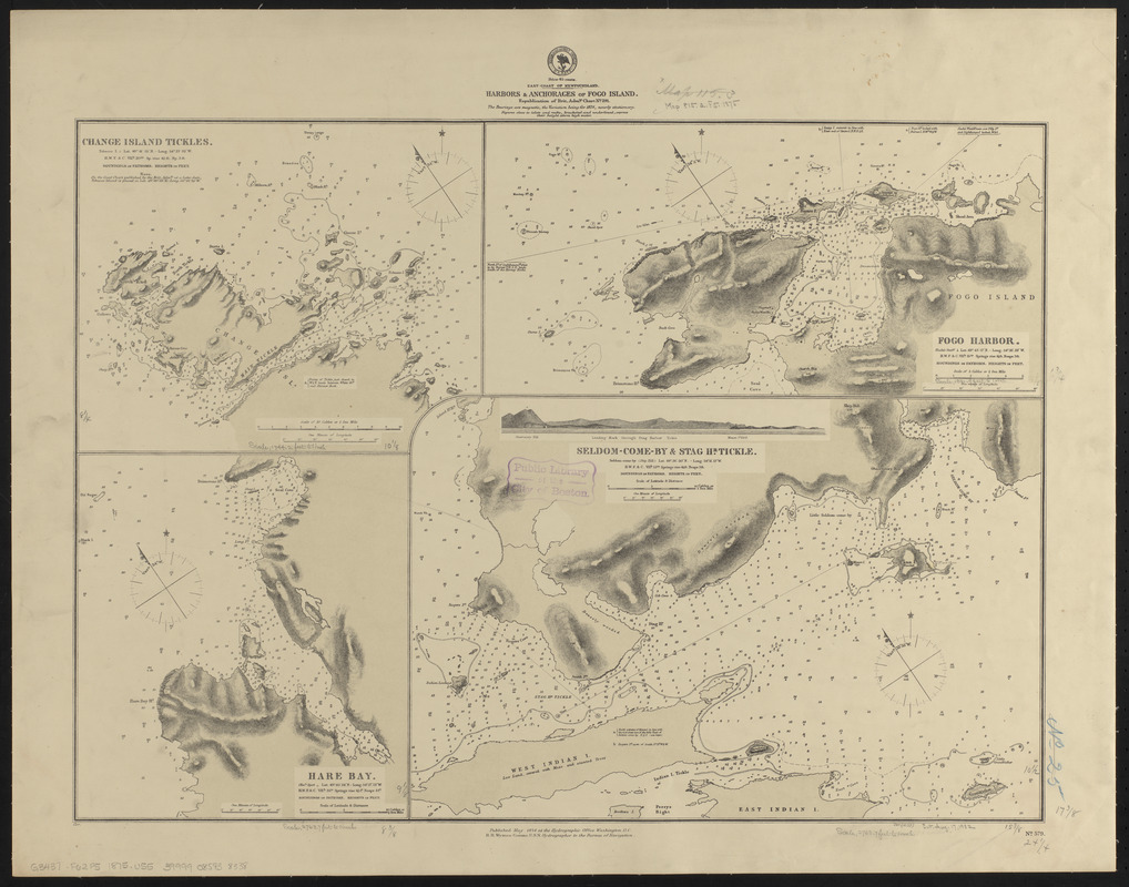
East-coast of Newfoundland, harbors & anchorages of Fogo Island : republication of Brit. Admty. chart no. 291
East-coast of Newfoundland, harbors & anchorages of Fogo Island
×
Item Information
Title:
East-coast of Newfoundland, harbors & anchorages of Fogo Island : republication of Brit. Admty. chart no. 291
Title (alt.):
Harbors & anchorages of Fogo Island
Issuing body:
United States. Hydrographic Office
Date:
1875
Format:
Maps/Atlases
Location:
Boston Public Library
Norman B. Leventhal Map & Education Center
Collection (local):
Norman B. Leventhal Map & Education Center Collection
Subjects:
Nautical charts--Newfoundland and Labrador--Fogo Island (Island)
Change Island Tickle (N.L.)--Maps
Deep Bay (N.L.)--Maps
Fogo Harbour (N.L.)--Maps
Seldom Harbour (N.L.)--Maps
Stag Harbour Run (N.L.)--Maps
Places:
Canada
>
Newfoundland and Labrador
(province)
>
Fogo
Change Islands Tickle
Deep Bay
Seldom Harbour
Stag Harbour Tickle
Extent:
4 maps on 1 sheet ; 45 x 62 cm
Permalink:
https://ark.digitalcommonwealth.org/ark:/50959/0z709d868
Terms of Use:
No known copyright restrictions.
No known restrictions on use.
Publisher:
Washington, D.C. : Hydrographic Office
Scale:
Scales differ
Language:
English
Table of Contents:
Change Island Tickles
Fogo Harbor
Hare Bay
Seldom-Come-By & Stag Hr. Tickle.
Notes:
Relief shown by hachures and spot heights. Depths shown by soundings and form lines.
Includes view of Leading mark through Stag Harbor Tickle.
"Cor. (11.75)."
Identifier:
06_01_015564
Call #:
G9096.P5 svar .U55
Barcode:
39999085938338
show more...
View MODS XML
More Like This
The 100th anniversary map of Abraham Lincoln's visit to ...
1630 shoreline
1879. Progress map of the U.S. Geographical Surveys west of the ...
1903 Map of Salem and surrounding places
Find More Like This >>
Tools
Share
Facebook
Pinterest
X
Reddit
Tumblr
Email
Copy link
Add to Folder
Questions/Comments
Cite This Item
IIIF Manifest
Downloads
Primary (full resolution, uncompressed)
(TIF, 85.9 MB)
Large (full resolution)
(JPEG, 7.21 MB)
Medium
(JPEG, 258 KB)