Skip to search
Skip to main content
Digital Commonwealth
Sign Up / Log In
Search for
Search
Search
Search
Basic
Advanced
Explore
Map
Collections
Institutions
Formats
For Educators
Primary Source Sets
Lesson Plans
Using Primary Sources
Searching Digital Commonwealth
For Institutions
Join Digital Commonwealth
Conferences, Trainings, & Events
How to Contribute Collections
Digitization Services
Board & Committees
Frequently Asked Questions
About
About Digital Commonwealth
News & Announcements
Copyright & Terms of Use
Harmful Content Statement
Partners
API
Contact Us
Boston Public Library
Norman B. Leventhal Map & Education Center Collection
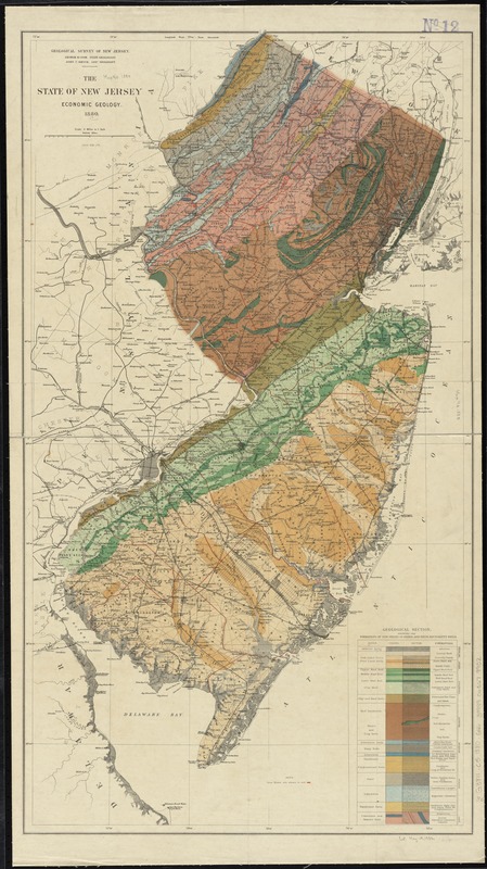
The state of New Jersey : economic geology
The state of New Jersey
×
Item Information
Title:
The state of New Jersey : economic geology
Title (alt.):
Economic geology
Creator:
Geological Survey of New Jersey
Name on Item:
Geological Survey of New Jersey.
Date:
1880
Format:
Maps/Atlases
Location:
Boston Public Library
Norman B. Leventhal Map & Education Center
Collection (local):
Norman B. Leventhal Map & Education Center Collection
Subjects:
Geology--New Jersey--Maps
Soils--New Jersey--Maps
Iron mines and mining--New Jersey--Maps
New Jersey--Maps
Places:
New Jersey
Extent:
1 map : col. ; 78 x 42 cm.
Permalink:
https://ark.digitalcommonwealth.org/ark:/50959/1257b8133
Terms of Use:
No known copyright restrictions.
No known restrictions on use.
Publisher:
[Trenton, N.J.] : The Survey
Scale:
Scale [1:380,160]. 6 miles to 1 inch
Language:
English
Notes:
Iron mines are shown in red.
"George H. Cook, State Geologist."
Includes "Geological section showing the formations of New Jersey in order, and their equivalent soils."
From: Annual report of the state geologist for the year 1879.
Identifier:
06_01_010880
Call #:
G3811.C5 1880 .G46
Barcode:
39999065679902
show more...
View MODS XML
More Like This
An historical map of Pennsylvania : showing the Indian names of ...
Manuscript maps of U.S. states, possibly drawn by a schoolchild
Map of the canals and rail roads for transporting anthracite coal ...
Map of the rail roads of New Jersey 1887
Find More Like This >>
Tools
Share
Facebook
Pinterest
X
Reddit
Tumblr
Email
Copy link
Add to Folder
Questions/Comments
Cite This Item
IIIF Manifest
Downloads
Primary (full resolution, uncompressed)
(TIF, 167 MB)
Large (full resolution)
(JPEG, 14 MB)
Medium
(JPEG, 163 KB)
GeoTIFF (georeferenced)
(TIF, 146 MB)
We'd love your feedback!
×
Would you be interested in taking a short survey about Digital Commonwealth?