Orbis terrarum typus de integro multis in locis emendatus
Item Information
- Title:
- Orbis terrarum typus de integro multis in locis emendatus
- Title (alt.):
-
Orbis terrarvm typvs de integro multis in locis emendatus
- Description:
-
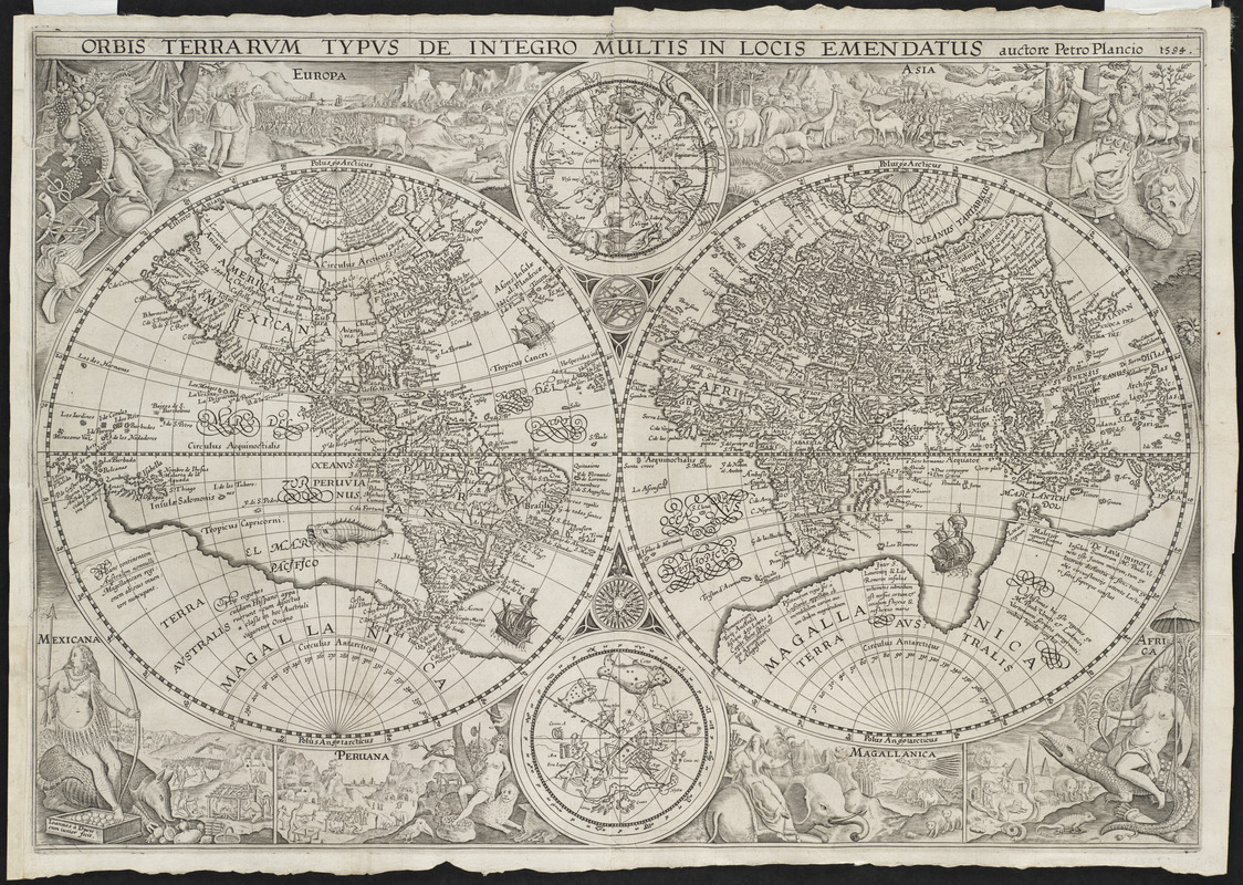
As was fairly common during the Golden Age of Dutch Cartography, this map projects the world on two hemispheres - Eastern and Western. It was the first richly decorated map of the period and influenced the art of cartography for the next century. Using female figures and animals representative of the respective regions, the decorative borders symbolize the six continents. Europe and Asia pictured as fully clothed figures were placed at the top of the map, expressing their superior culture and dominance over the rest of the world. The other continents - Mexicana (North America), Peruana (South America), Magallanica (the still hypothetical Antarctica), and Africa - were placed at the bottom suggesting their inferior status. Plancius, the creator of this world map, was a Flemish astronomer, geographer, and theologian. He also served as a cartographer for the Dutch East India Company.
- Creator:
- Plancius, Petrus, 1552-1622
- Engraver:
- Doetecam, Jan van
- Name on Item:
-
auctore Petro Plancio, 1594 ; Ioannes à Duetecum iunior fecit.
- Date:
-
[1594]
- Format:
-
Maps/Atlases
- Location:
- Private Collection
- Collection (local):
-
Mapping Boston Collection
- Subjects:
-
World maps--Early works to 1800
- Places:
-
World
- Extent:
- 1 map ; 2 hemispheres each 28 cm. diam. on sheet 41 x 58 cm.
- Permalink:
- https://ark.digitalcommonwealth.org/ark:/50959/3f462s46z
- Terms of Use:
-
No known copyright restrictions.
This work is licensed for use under a Creative Commons Attribution Non-Commercial Share Alike License (CC BY-NC-SA).


![Hemispheriu[m] ab aequinoctiali linea, ad circulu[m] Poli Arctici](https://bpldcassets.blob.core.windows.net/derivatives/images/commonwealth:3f462s45p/image_thumbnail_300.jpg)

Downloads