Skip to search
Skip to main content
Digital Commonwealth
Sign Up / Log In
Search for
Search
Search
Search
Basic
Advanced
Explore
Map
Collections
Institutions
Formats
For Educators
Primary Source Sets
Lesson Plans
Using Primary Sources
Searching Digital Commonwealth
For Institutions
Join Digital Commonwealth
Conferences, Trainings, & Events
How to Contribute Collections
Digitization Services
Board & Committees
Frequently Asked Questions
About
About Digital Commonwealth
News & Announcements
Copyright & Terms of Use
Harmful Content Statement
Partners
API
Contact Us
Boston Public Library
Norman B. Leventhal Map & Education Center Collection
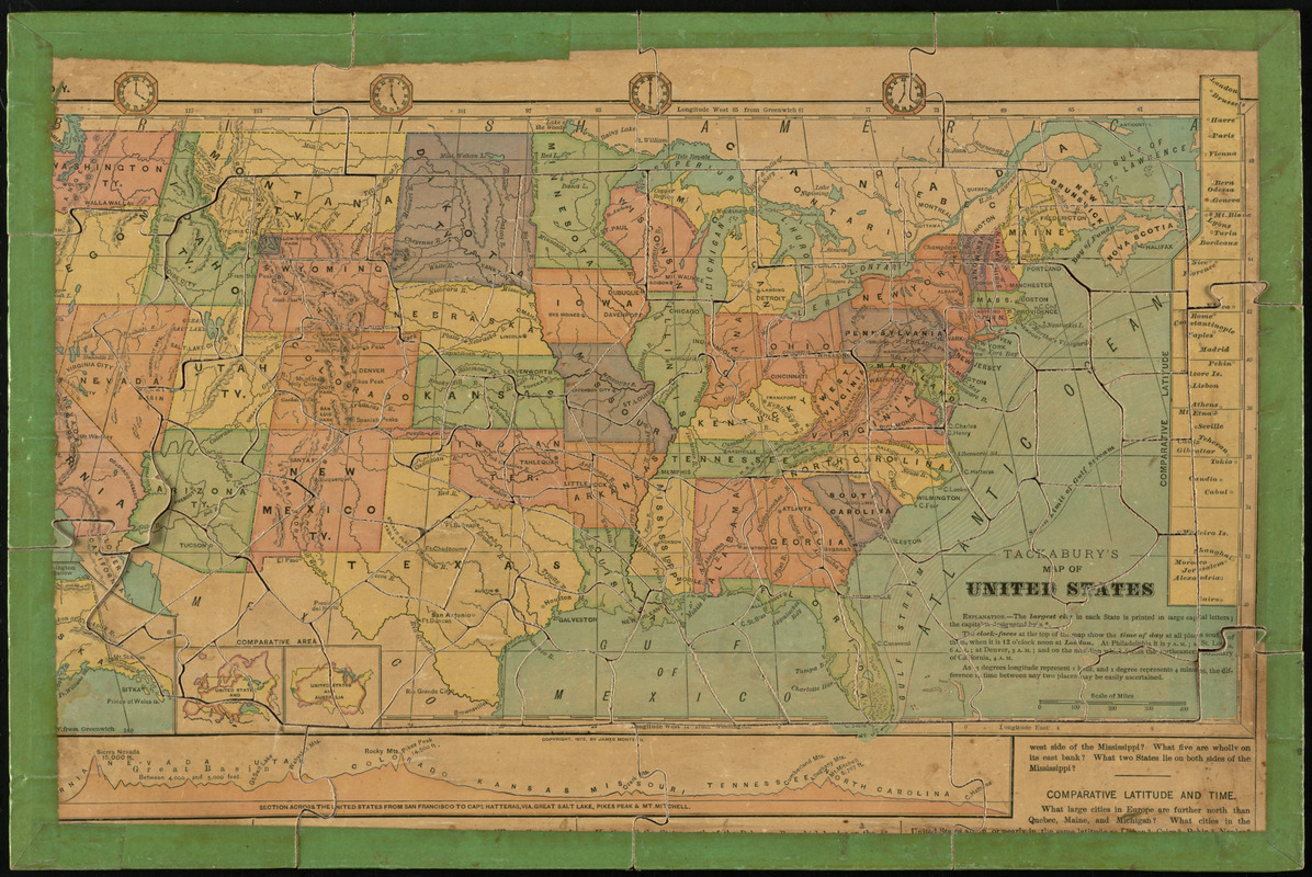
Tackabury's map of United States
Tackaburys map of United States
×
Item Information
Title:
Tackabury's map of United States
Cartographer:
Clemens, E. J.
Date:
[1880?–1889?]
Format:
Maps/Atlases
Location:
Boston Public Library
Norman B. Leventhal Map & Education Center
Collection (local):
Norman B. Leventhal Map & Education Center Collection
Subjects:
Jigsaw puzzles
United States--Maps
Places:
United States
Extent:
1 map : color ; 21 x 40 cm
Permalink:
https://ark.digitalcommonwealth.org/ark:/50959/3f463976z
Terms of Use:
No known copyright restrictions.
No known restrictions on use.
Publisher:
Clayville, N.Y. : Rev. E. J. Clemens
Scale:
Scale approximately 1:13,400,000
Language:
English
Notes:
Double-sided puzzle, with a map of Pennsylania on one side and a map of the United States on the other. Pieces cut along Pennsylvania county lines.
Identifier:
06_01_008270
Call #:
G3821.F7 1880 .C54x
Barcode:
39999065651034
show more...
View MODS XML
More Like This
Clemens' silent teacher, dissected map of the United States and of ...
Map of the United States
Clemens' map of Pennsylvania
Map of Maine for the Maine register
Find More Like This >>
Tools
Share
Facebook
Pinterest
X
Reddit
Tumblr
Email
Copy link
Add to Folder
Questions/Comments
Cite This Item
IIIF Manifest
Downloads
Primary (full resolution, uncompressed)
(TIF, 43.1 MB)
Large (full resolution)
(JPEG, 3.62 MB)
Medium
(JPEG, 494 KB)
GeoTIFF (georeferenced)
(TIF, 57 MB)
We'd love your feedback!
×
Would you be interested in taking a short survey about Digital Commonwealth?