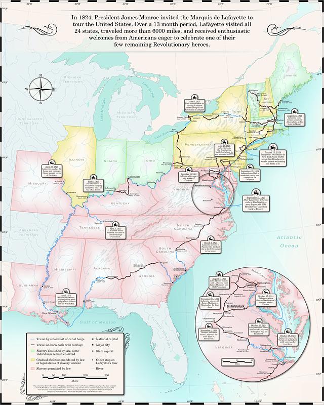
Map of the Marquis de Lafayette's 1824-1825 tour of the United States
Item Information
- Title:
- Map of the Marquis de Lafayette's 1824-1825 tour of the United States
- Cartographer:
- Prevedel, Brooke
- Cartographer:
- Hanna, Stephen P.
- Name on Item:
-
map created by Brooke Prevedel (UMW 2024) and Stephen P. Hanna (professor, UMW Geography).
- Date:
-
[2023]
- Format:
-
Maps/Atlases
- Location:
-
Boston Public Library
Norman B. Leventhal Map & Education Center - Collection (local):
-
Norman B. Leventhal Map & Education Center Collection
- Subjects:
-
United States--Maps
United States--History--1815-1861
Slavery--United States--Maps
Lafayette, Marie Joseph Paul Yves Roch Gilbert Du Motier, marquis de, 1757-1834
- Places:
-
United States
- Extent:
- 1 map : color
- Permalink:
- https://ark.digitalcommonwealth.org/ark:/50959/4168dk617
- Terms of Use:
-
Under copyright.
This work is licensed for use under a Creative Commons Attribution License (CC BY).