Skip to search
Skip to main content
Digital Commonwealth
Sign Up / Log In
Search for
Search
Search
Search
Basic
Advanced
Explore
Map
Collections
Institutions
Formats
For Educators
Primary Source Sets
Lesson Plans
Using Primary Sources
Searching Digital Commonwealth
For Institutions
Join Digital Commonwealth
Conferences, Trainings, & Events
How to Contribute Collections
Digitization Services
Board & Committees
Frequently Asked Questions
About
About Digital Commonwealth
News & Announcements
Copyright & Terms of Use
Harmful Content Statement
Partners
API
Contact Us
Boston Public Library
Norman B. Leventhal Map & Education Center Collection
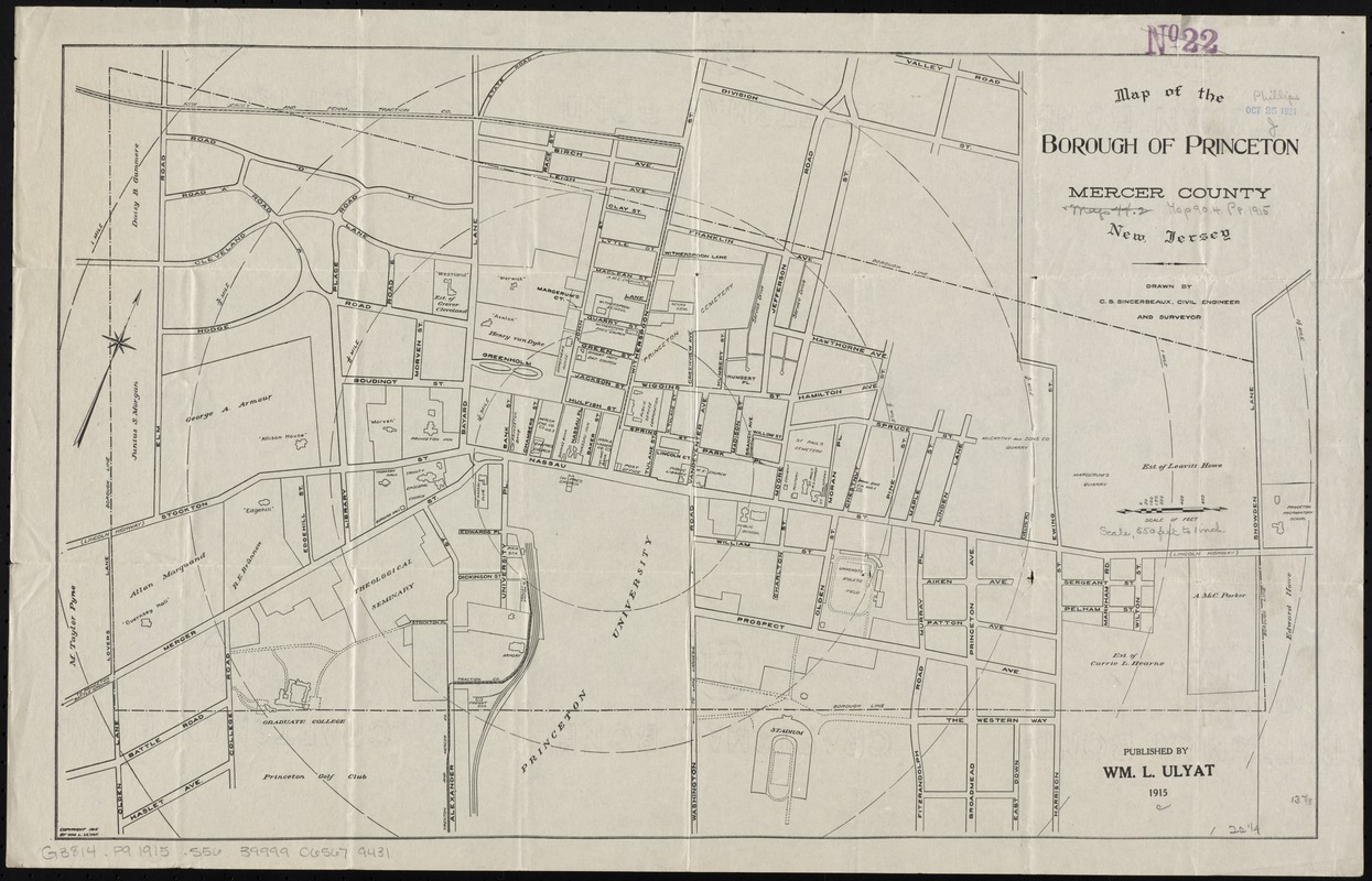
Map of the borough of Princeton, Mercer County, New Jersey
Map of the borough of Princeton, Mercer County, New Jersey
×
Item Information
Title:
Map of the borough of Princeton, Mercer County, New Jersey
Creator:
Sincerbeaux, C. S.
Name on Item:
drawn by C.S. Sincerbeaux, civil engineer and surveyor.
Date:
1915
Format:
Maps/Atlases
Location:
Boston Public Library
Norman B. Leventhal Map & Education Center
Collection (local):
Norman B. Leventhal Map & Education Center Collection
Subjects:
Real property--New Jersey--Princeton--Maps
Princeton (N.J.)--Maps
Places:
New Jersey
>
Mercer (county)
>
Princeton
Extent:
1 map ; 36 x 57 cm.
Permalink:
https://ark.digitalcommonwealth.org/ark:/50959/4m90f473w
Terms of Use:
No known copyright restrictions.
No known restrictions on use.
Publisher:
[Princeton, N.J.] : Published by Wm. L. Ulyat
Scale:
Scale [ca. 1:6,600]
Language:
English
Notes:
Shows some buildings and property owners.
Identifier:
06_01_010906
Call #:
G3814.P9 1915 .S56
Barcode:
39999065679431
show more...
View MODS XML
More Like This
The 100th anniversary map of Abraham Lincoln's visit to ...
1630 shoreline
1879. Progress map of the U.S. Geographical Surveys west of the ...
1903 Map of Salem and surrounding places
Find More Like This >>
Tools
Share
Facebook
Pinterest
X
Reddit
Tumblr
Email
Copy link
Add to Folder
Questions/Comments
Cite This Item
IIIF Manifest
Downloads
Primary (full resolution, uncompressed)
(TIF, 100 MB)
Large (full resolution)
(JPEG, 8.42 MB)
Medium
(JPEG, 303 KB)
GeoTIFF (georeferenced)
(TIF, 92.9 MB)
We'd love your feedback!
×
Would you be interested in taking a short survey about Digital Commonwealth?