Skip to search
Skip to main content
Digital Commonwealth
Sign Up / Log In
Search for
Search
Search
Search
Basic
Advanced
Explore
Map
Collections
Institutions
Formats
For Educators
Primary Source Sets
Lesson Plans
Using Primary Sources
Searching Digital Commonwealth
For Institutions
Join Digital Commonwealth
Conferences, Trainings, & Events
How to Contribute Collections
Digitization Services
Board & Committees
Frequently Asked Questions
About
About Digital Commonwealth
News & Announcements
Copyright & Terms of Use
Harmful Content Statement
Partners
API
Contact Us
Boston Public Library
Norman B. Leventhal Map & Education Center Collection
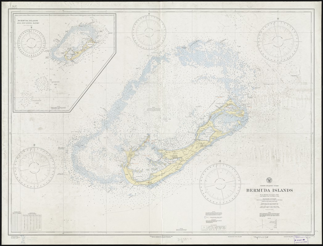
North Atlantic Ocean, Bermuda Islands : from British surveys to 1926, with additions and corrections to 1936
North Atlantic Ocean, Bermuda Islands
×
Item Information
Title:
North Atlantic Ocean, Bermuda Islands : from British surveys to 1926, with additions and corrections to 1936
Title (alt.):
Bermuda Islands
Title (uniform):
Charts, etc
Creator:
United States. Hydrographic Office
Date:
1938
Format:
Maps/Atlases
Location:
Boston Public Library
Norman B. Leventhal Map & Education Center
Collection (local):
Norman B. Leventhal Map & Education Center Collection
Subjects:
Navigation--Bermuda Islands
Bermuda Islands--Maps
Places:
Bermuda
(territory)
Extent:
1 chart : col. ; 80 x 109 cm.
Permalink:
https://ark.digitalcommonwealth.org/ark:/50959/4m90fj43n
Terms of Use:
No known copyright restrictions.
No known restrictions on use.
Publisher:
Washington, D.C : Hydrographic Office
Edition:
New publication, 72nd ed., May, 1938.
Scale:
Scale 1:50,000
Language:
English
Notes:
Relief shown by spot heights. Depths shown by soundings and isolines.
Inset: Bermuda Islands and off-lying banks.
No. 27.
Identifier:
06_01_011451
Call #:
G9121.P5 1938 .U55
Barcode:
39999065691881
show more...
View MODS XML
More Like This
Heathers, improved chart of the Bermudas, drawn from the best surveys
A map of the Bermuda Islands : ya des demonios, isles of the devils
North Atlantic Ocean, Bermuda Islands : from the most recent Brit. ...
The British governments in Nth. America : laid down agreeable to ...
Find More Like This >>
Tools
Share
Facebook
Pinterest
X
Reddit
Tumblr
Email
Copy link
Add to Folder
Questions/Comments
Cite This Item
IIIF Manifest
Downloads
Primary (full resolution, uncompressed)
(TIF, 471 MB)
Large (full resolution)
(JPEG, 39.6 MB)
Medium
(JPEG, 246 KB)