Skip to search
Skip to main content
Digital Commonwealth
Sign Up / Log In
Search for
Search
Search
Search
Basic
Advanced
Explore
Map
Collections
Institutions
Formats
For Educators
Primary Source Sets
Lesson Plans
Using Primary Sources
Searching Digital Commonwealth
For Institutions
Join Digital Commonwealth
Conferences, Trainings, & Events
How to Contribute Collections
Digitization Services
Board & Committees
Frequently Asked Questions
About
About Digital Commonwealth
News & Announcements
Copyright & Terms of Use
Harmful Content Statement
Partners
API
Contact Us
Boston Public Library
Norman B. Leventhal Map & Education Center Collection
Europe
Europe
×
Item Information
Title:
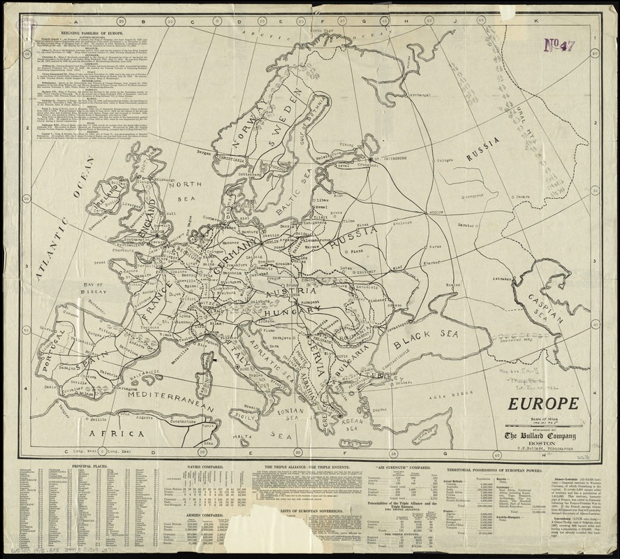
Europe
Creator:
Bullard, G. E.
Name on Item:
G.E. Bullard, topographer.
Date:
[1915]
Format:
Maps/Atlases
Location:
Boston Public Library
Norman B. Leventhal Map & Education Center
Collection (local):
Norman B. Leventhal Map & Education Center Collection
Subjects:
World War, 1914-1918--Maps
Europe--Maps
Places:
Europe
Europe
Extent:
1 map ; 44 x 58 cm.
Permalink:
https://ark.digitalcommonwealth.org/ark:/50959/4m90fm63j
Terms of Use:
No known copyright restrictions.
No known restrictions on use.
Publisher:
Boston : The Bullard Company,
Scale:
Scale 1:8,870,400. 140 mi. to 1 in.
Language:
English
Notes:
Date estimated from text.
Relief shown by hachures.
Indexed.
Includes text and statistics on reigning families, navies, armies, territories, etc.
Notes (date):
This date is inferred.
Identifier:
06_01_012038
Call #:
G5700 1915 .B85
Barcode:
39999065692871
show more...
View MODS XML
More Like This
Daily mail war map
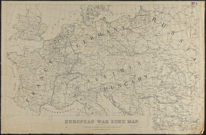
European war zone map
Hark! Hark! The dogs do bark! : with note by Walter Emanuel = ...
The Literary Digest liberty map of the Western Front of the Great ...
Find More Like This >>
Tools
Share
Facebook
Pinterest
X
Reddit
Tumblr
Email
Copy link
Add to Folder
Questions/Comments
Cite This Item
IIIF Manifest
Downloads
Primary (full resolution, uncompressed)
(TIF, 141 MB)
Large (full resolution)
(JPEG, 11.9 MB)
Medium
(JPEG, 295 KB)
GeoTIFF (georeferenced)
(TIF, -1 Bytes)