Skip to search
Skip to main content
Digital Commonwealth
Sign Up / Log In
Search for
Search
Search
Search
Basic
Advanced
Explore
Map
Collections
Institutions
Formats
For Educators
Primary Source Sets
Lesson Plans
Using Primary Sources
Searching Digital Commonwealth
For Institutions
Join Digital Commonwealth
Conferences, Trainings, & Events
How to Contribute Collections
Digitization Services
Board & Committees
Frequently Asked Questions
About
About Digital Commonwealth
News & Announcements
Copyright & Terms of Use
Harmful Content Statement
Partners
API
Contact Us
Boston Public Library
Norman B. Leventhal Map & Education Center Collection
/
Urban Maps (Collection of Distinction)
/
Boston and New England Maps (Collection of Distinction)
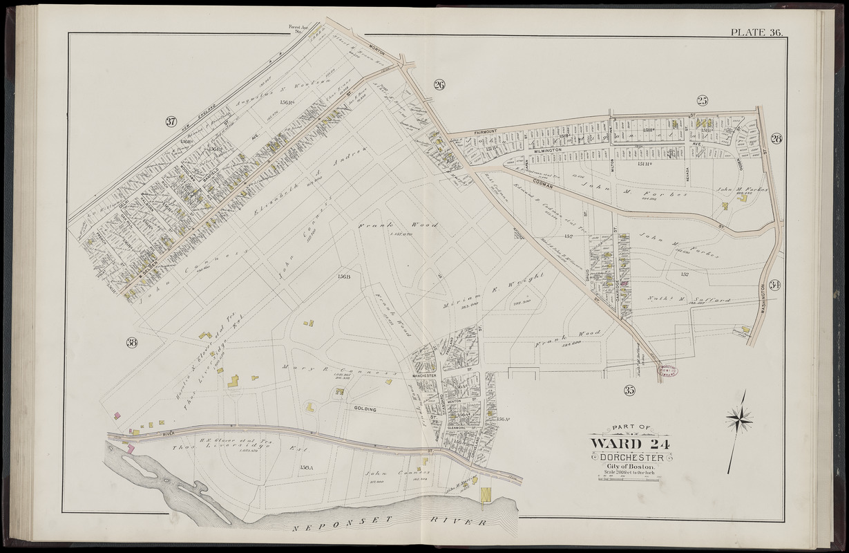
Atlas of the city of Boston, Dorchester, Mass., vol. 5 : from actual surveys and official plans : plate 36
Atlas of the city of Boston, Dorchester, Mass., vol. 5 : from actual surveys and official plans
×
Item Information
Title:
Atlas of the city of Boston, Dorchester, Mass., vol. 5 : from actual surveys and official plans : plate 36
Title (alt.):
Part of ward 24, Dorchester, city of Boston
Cartographer:
Bromley, George Washington
Publisher:
G.W. Bromley & Co.
Cartographer:
Bromley, Walter Scott
Date:
1898
Format:
Maps/Atlases
Location:
Boston Public Library
Norman B. Leventhal Map & Education Center
Collection (local):
Norman B. Leventhal Map & Education Center Collection
Subjects:
Real property--Massachusetts--Boston--Maps
Landowners--Massachusetts--Boston--Maps
Mattapan (Boston, Mass.)--Maps
Places:
Massachusetts
>
Suffolk (county)
>
Boston
>
Mattapan
Extent:
1 map : color ; sheet 58 x 83 cm
Permalink:
https://ark.digitalcommonwealth.org/ark:/50959/6h446x73b
Terms of Use:
No known copyright restrictions.
No known restrictions on use.
Publisher:
Philadelphia : G.W. Bromley and Co.
Edition:
Third edition
Scale:
Scale 1:2,400
Language:
English
Notes:
Digitization made possible with support from the Council on Library and Information Resources.
Identifier:
G1234_B6_B7_1898_2v5_0039
Call #:
G1234.B6 B7 1898.2 v.5
Barcode:
39999059011229
show more...
View MODS XML
More Like This
Atlas of Dorchester, West Roxbury and Brighton, city of Boston
Atlas of Dorchester, West Roxbury and Brighton, city of Boston : ...
Atlas of Dorchester, West Roxbury and Brighton, city of Boston : ...
Atlas of Dorchester, West Roxbury and Brighton, city of Boston : ...
Find More Like This >>
Tools
Share
Facebook
Pinterest
X
Reddit
Tumblr
Email
Copy link
Add to Folder
Questions/Comments
Cite This Item
IIIF Manifest
Downloads
Primary (full resolution, uncompressed)
(TIF, 138 MB)
Large (full resolution)
(JPEG, 11.6 MB)
Medium
(JPEG, 276 KB)
We'd love your feedback!
×
Would you be interested in taking a short survey about Digital Commonwealth?