Skip to search
Skip to main content
Digital Commonwealth
Sign Up / Log In
Search for
Search
Search
Search
Basic
Advanced
Explore
Map
Collections
Institutions
Formats
For Educators
Primary Source Sets
Lesson Plans
Using Primary Sources
Searching Digital Commonwealth
For Institutions
Join Digital Commonwealth
Conferences, Trainings, & Events
How to Contribute Collections
Digitization Services
Board & Committees
Frequently Asked Questions
About
About Digital Commonwealth
News & Announcements
Copyright & Terms of Use
Harmful Content Statement
Partners
API
Contact Us
Boston Public Library
Norman B. Leventhal Map & Education Center Collection
/
Boston and New England Maps (Collection of Distinction)
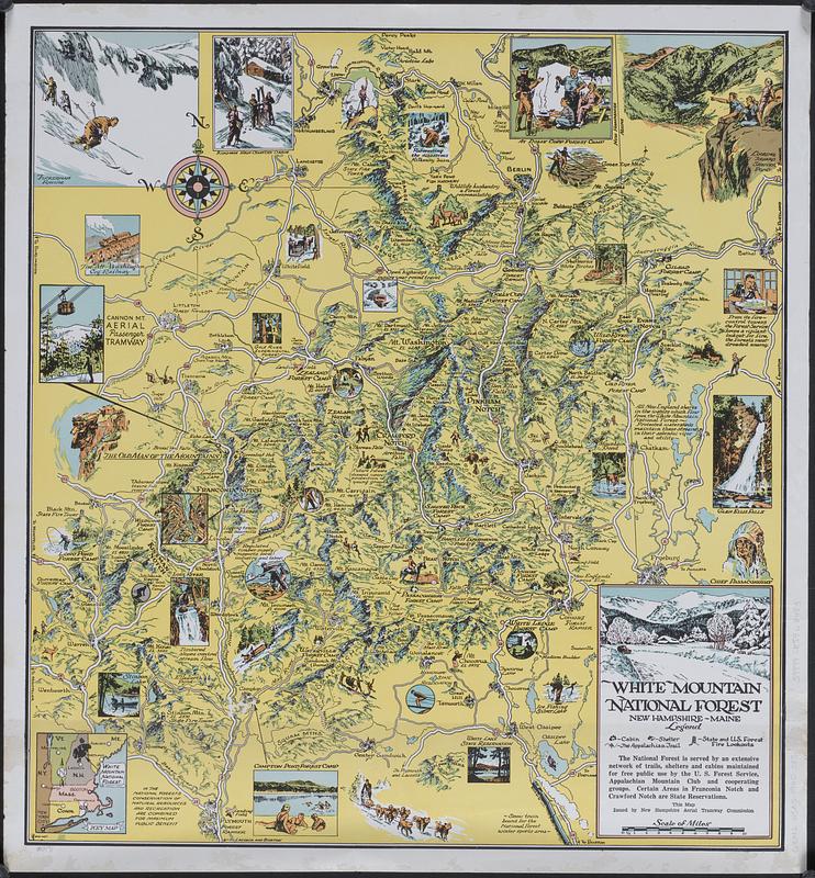
White Mountain National Forest : New Hampshire-Maine
White Mountain National Forest
×
Item Information
Title:
White Mountain National Forest : New Hampshire-Maine
Cartographer:
Culverwell, Tom
Publisher:
New Hampshire Aerial Tramway Commission
Name on Item:
Culverwell
Date:
[1940–1949]
Format:
Maps/Atlases
Genre:
Pictorial maps
Tourist maps
Location:
Boston Public Library
Norman B. Leventhal Map & Education Center
Collection (local):
Norman B. Leventhal Map & Education Center Collection
Subjects:
White Mountain National Forest (N.H. and Me.)--Maps
Places:
New Hampshire
>
Grafton (county)
White Mountain National Forest
Extent:
1 map : color ; 47 x 44 cm on sheet 51 x 47 cm
Permalink:
https://ark.digitalcommonwealth.org/ark:/50959/7m01fs602
Terms of Use:
No known copyright restrictions.
No known restrictions on use.
Publisher:
[Concord?] : New Hampshire Aerial Tramway Commission
Scale:
Scale approximately 1:225,000
Language:
English
Notes:
Relief shown by shading and pictorially.
"This map issued by New Hampshire Aerial Tramway Commission."
Includes key map inset, text, and color illustrations.
Notes (date):
This date is inferred.
Identifier:
06_01_018555
Call #:
G3742.W5A5 1940 .C85
Barcode:
39999085968483
show more...
View MODS XML
More Like This
White Mountain region, New Hampshire : showing lands being ...
The 100th anniversary map of Abraham Lincoln's visit to ...
1630 shoreline
1879. Progress map of the U.S. Geographical Surveys west of the ...
Find More Like This >>
Tools
Share
Facebook
Pinterest
X
Reddit
Tumblr
Email
Copy link
Add to Folder
Questions/Comments
Cite This Item
IIIF Manifest
Downloads
Primary (full resolution, uncompressed)
(TIF, 94.3 MB)
Large (full resolution)
(JPEG, 7.92 MB)
Medium
(JPEG, 214 KB)
We'd love your feedback!
×
Would you be interested in taking a short survey about Digital Commonwealth?