Skip to search
Skip to main content
Digital Commonwealth
Sign Up / Log In
Search for
Search
Search
Search
Basic
Advanced
Explore
Map
Collections
Institutions
Formats
For Educators
Primary Source Sets
Lesson Plans
Using Primary Sources
Searching Digital Commonwealth
For Institutions
Join Digital Commonwealth
Conferences, Trainings, & Events
How to Contribute Collections
Digitization Services
Board & Committees
Frequently Asked Questions
About
About Digital Commonwealth
News & Announcements
Copyright & Terms of Use
Harmful Content Statement
Partners
API
Contact Us
Boston Public Library
Norman B. Leventhal Map & Education Center Collection
/
Maritime Charts and Atlases (Collection of Distinction)
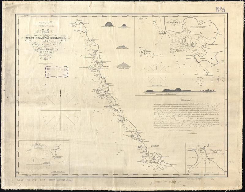
Chart of the west coast of Sumatra between Rigas and Diah from actual survey
Chart of the west coast of Sumatra between Rigas and Diah from actual survey
×
Item Information
Title:
Chart of the west coast of Sumatra between Rigas and Diah from actual survey
Cartographer:
Gillis, James D. (James Dunlap), 1798-1835
Publisher:
Ives, John M., 1798-1883
Engraver:
Annin, William B., 1791?-1839
Name on Item:
by James D. Gillis ; W.B. Annin, sc.
Date:
1834
Format:
Maps/Atlases
Genre:
Nautical charts
Location:
Boston Public Library
Norman B. Leventhal Map & Education Center
Collection (local):
Norman B. Leventhal Map & Education Center Collection
Subjects:
Sumatra (Indonesia)--Maps
Coasts--Indonesia--Sumatra--Maps
Nautical charts--Indonesia--Sumatra
Places:
Indonesia
>
Sumatra
(island)
Extent:
1 map ; 39 x 52 cm
Permalink:
https://ark.digitalcommonwealth.org/ark:/50959/7w62hs27p
Terms of Use:
No known copyright restrictions.
No known restrictions on use.
Publisher:
Salem, Mass. : John M. Ives
Scale:
Scale approximately 1:145,000
Language:
English
Notes:
Relief shown by hachures. Depths shown by soundings.
Insets: Plan of Analaboo Anchorage -- Plan of Rigas Bay -- Plan of the passage between Pulo Riah and the main.
Includes remarks and 5 coastal views.
Identifier:
06_01_017534
Call #:
G8081.P5 1834 .G45
Barcode:
39999085960464
show more...
View MODS XML
More Like This
Sumatra wegenkaart
The 100th anniversary map of Abraham Lincoln's visit to ...
1630 shoreline
1879. Progress map of the U.S. Geographical Surveys west of the ...
Find More Like This >>
Tools
Share
Facebook
Pinterest
X
Reddit
Tumblr
Email
Copy link
Add to Folder
Questions/Comments
Cite This Item
IIIF Manifest
Downloads
Primary (full resolution, uncompressed)
(TIF, 109 MB)
Large (full resolution)
(JPEG, 9.18 MB)
Medium
(JPEG, 98 KB)