Skip to search
Skip to main content
Digital Commonwealth
Sign Up / Log In
Search for
Search
Search
Search
Basic
Advanced
Explore
Map
Collections
Institutions
Formats
For Educators
Primary Source Sets
Lesson Plans
Using Primary Sources
Searching Digital Commonwealth
For Institutions
Join Digital Commonwealth
Conferences, Trainings, & Events
How to Contribute Collections
Digitization Services
Board & Committees
Frequently Asked Questions
About
About Digital Commonwealth
News & Announcements
Copyright & Terms of Use
Harmful Content Statement
Partners
API
Contact Us
Boston Public Library
Norman B. Leventhal Map & Education Center Collection
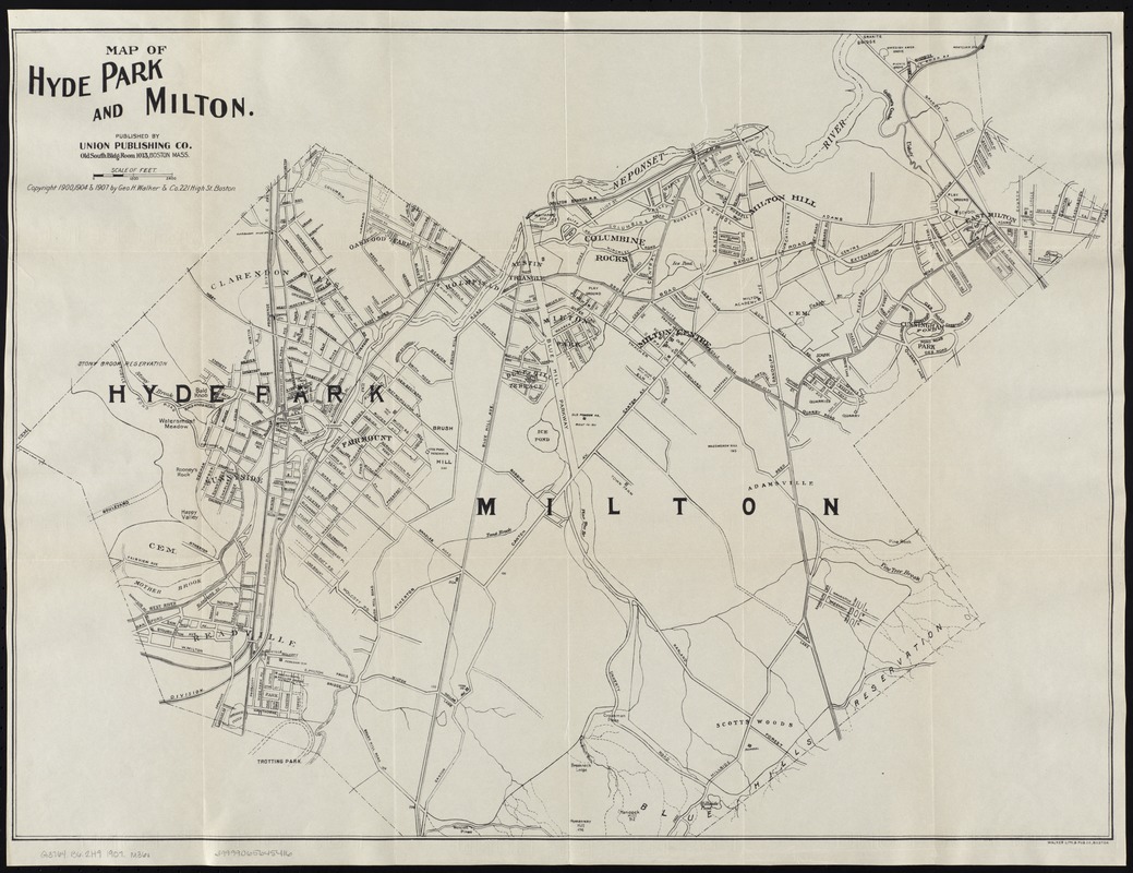
Map of Hyde Park and Milton
Map of Hyde Park and Milton
×
Item Information
Title:
Map of Hyde Park and Milton
Date:
[ca. 1907]
Format:
Maps/Atlases
Location:
Boston Public Library
Norman B. Leventhal Map & Education Center
Collection (local):
Norman B. Leventhal Map & Education Center Collection
Subjects:
Hyde Park (Boston, Mass.)--Maps
Milton (Mass.)--Maps
Places:
Massachusetts
>
Suffolk (county)
>
Boston
>
Hyde Park
Massachusetts
>
Norfolk (county)
>
Milton
Extent:
1 map ; 51 x 70 cm.
Permalink:
https://ark.digitalcommonwealth.org/ark:/50959/8336h326z
Terms of Use:
No known copyright restrictions.
No known restrictions on use.
Publisher:
Boston : Union Pub. Co.
Scale:
Scale ca. [1:14,400].
Language:
English
Notes:
Copyright by Geo. W. Walker & Co., 1900, 1904 and 1907.
Identifier:
06_01_007620
Call #:
G3764.B6:2H9 1907 .M36x
Barcode:
39999065645416
show more...
View MODS XML
More Like This
Hyde Park & Fairmount : in Dorchester & Milton, Norfolk Co
Map of Hyde Park and Milton
Atlas of the boundaries of the city of Quincy and towns of Avon, ...
Atlas of the town of Milton Norfolk County Mass. : from official ...
Find More Like This >>
Tools
Share
Facebook
Pinterest
X
Reddit
Tumblr
Email
Copy link
Add to Folder
Questions/Comments
Cite This Item
IIIF Manifest
Downloads
Primary (full resolution, uncompressed)
(TIF, 101 MB)
Large (full resolution)
(JPEG, 8.5 MB)
Medium
(JPEG, 267 KB)