Skip to search
Skip to main content
Digital Commonwealth
Sign Up / Log In
Search for
Search
Search
Search
Basic
Advanced
Explore
Map
Collections
Institutions
Formats
For Educators
Primary Source Sets
Lesson Plans
Using Primary Sources
Searching Digital Commonwealth
For Institutions
Join Digital Commonwealth
Conferences, Trainings, & Events
How to Contribute Collections
Digitization Services
Board & Committees
Frequently Asked Questions
About
About Digital Commonwealth
News & Announcements
Copyright & Terms of Use
Harmful Content Statement
Partners
API
Contact Us
Boston Public Library
Norman B. Leventhal Map & Education Center Collection
/
Boston and New England Maps (Collection of Distinction)
/
Applied Geographics, Inc. Records
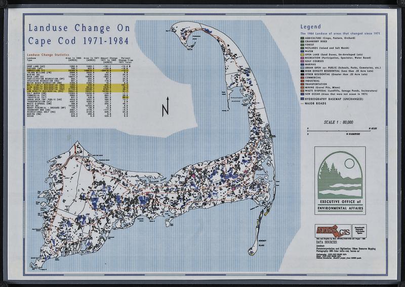
Landuse change on Cape Cod 1971-1984
Landuse change on Cape Cod 1971-1984
×
Item Information
Title:
Landuse change on Cape Cod 1971-1984
Title (alt.):
Land use change on Cape Cod 1971-1984
Cartographer:
Massachusetts. Executive Office of Environmental Affairs
Contributor:
MassGIS (Office : Mass.)
Name on Item:
Executive Office of Environmental Affairs
Date:
[ca. 1988]
Format:
Maps/Atlases
Genre:
Thematic maps
Location:
Boston Public Library
Norman B. Leventhal Map & Education Center
Collection (local):
Applied Geographics, Inc. Records
Subjects:
Cape Cod (Mass.)--Maps
Land use--Massachusetts--Cape Cod--Maps
Places:
Massachusetts
>
Barnstable (county)
>
Cape Cod
(area)
Extent:
1 map : color, plastic-coated ; 27 x 37 cm
Permalink:
https://ark.digitalcommonwealth.org/ark:/50959/8s45vn92x
Terms of Use:
No known copyright restrictions.
No known restrictions on use.
Publisher:
[Massachusetts] : Executive Office of Environmental Affairs
Scale:
Scale 1:80,000
Language:
English
Notes:
"Data and graphics by Mass. HWFSSC/USGS-WRD GIS Project - 1988."
Includes landuse change statistics.
Identifier:
06_01_018910
Call #:
AppGeo Folder 3 no. 8
Barcode:
30000008056476
show more...
View MODS XML
More Like This
Cape Cod
Cape Cod, Barnstable County, Mass.
Cape Cod open space : SCORP-GIS integration project
Historic Massachusetts : a travel map to help you feel at home in ...
Find More Like This >>
Tools
Share
Facebook
Pinterest
X
Reddit
Tumblr
Email
Copy link
Add to Folder
Questions/Comments
Cite This Item
IIIF Manifest
Downloads
Primary (full resolution, uncompressed)
(TIF, 63.4 MB)
Large (full resolution)
(JPEG, 5.32 MB)
Medium
(JPEG, 113 KB)