Boston Public LibraryNorman B. Leventhal Map & Education Center Collection / American Revolutionary War-Era Maps (Collection of Distinction) / Maritime Charts and Atlases (Collection of Distinction)
The coast of Nova Scotia, New England, New-York, Jersey, the Gulph and River of St. Lawrence : the islands of Newfoundland, Cape Breton, St. John, Antecosty, Sable, & c, and soundings thereof
Item Information
- Title:
- The coast of Nova Scotia, New England, New-York, Jersey, the Gulph and River of St. Lawrence : the islands of Newfoundland, Cape Breton, St. John, Antecosty, Sable, & c, and soundings thereof
- Description:
-
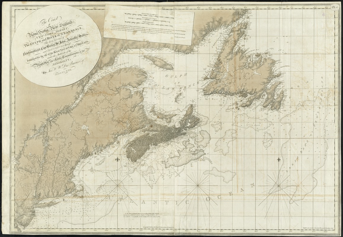
This chart of the northeast coast of North America is the most comprehensive map in The Atlantic Neptune, covering the largest geographic area. It was produced using the latest scientific technology available for marine surveying in the second half of the 18th century, resulting in a chart that remains remarkably accurate for being over two hundred years old. Illustrating the northern district of Britain's North American empire, Des Barres' chart bears a striking resemblance to a modern Canadian Hydrographic Service chart of the same area.
- Creator:
- Des Barres, Joseph F. W. (Joseph Frederick Wallet), 1722-1824
- Name on Item:
-
by Jos. F.W. Des Barres Esqr., MDCCLXXX.
- Date:
-
1780
- Format:
-
Maps/Atlases
- Location:
-
Boston Public Library
Norman B. Leventhal Map & Education Center - Collection (local):
-
Norman B. Leventhal Map & Education Center Collection
- Subjects:
-
Nautical charts--Atlantic Coast (Maritime Provinces)--Early works to 1800
Nautical charts--Atlantic Coast (New England)--Early works to 1800
Nautical charts--Atlantic Coast (Middle Atlantic States)--Early works to 1800
Coasts--Maritime Provinces--Maps--Early works to 1800
Coasts--New England--Maps--Early works to 1800
Coasts--Middle Atlantic States--Maps--Early works to 1800
Atlantic Coast (Maritime Provinces)--Maps--Early works to 1800
Atlantic Coast (New England)--Maps--Early works to 1800
Atlantic Coast (Middle Atlantic States)--Maps--Early works to 1800
- Places:
-
New England (area)
Middle Atlantic (area)
Canada > Province of Prince Edward Island (province)
- Extent:
- 1 map ; 80 x 117 cm.
- Permalink:
- https://ark.digitalcommonwealth.org/ark:/50959/9g54xk56c
- Terms of Use:
-
No known copyright restrictions.
No known restrictions on use.
- Publisher:
-
[London] :
Publish'd ... November 1st. 1780 by I.F.W. Des Barres Esqr
- Edition:
- 9th state.
- Scale:
-
Scale ca. 1:2,000,000
- Language:
-
English
- Notes:
-
Relief shown by shading. Soundings in fathoms.
Shows tidal depths and bottom conditions.
"Published for the use of the Royal Navy of Great Britain ..."
In upper right corner: PL. 4.
Appears in the author's Atlantic Neptune. London : [J.F.W. Des Barres], 1777-[1781].
- Notes (exhibitions):
-
Exhibited: "Charting an Empire: The Atlantic Neptune" organized by the Norman B. Leventhal Map Center at the Boston Public Library, 2013.
- Identifier:
-
06_01_008060
- Call #:
-
G1106.P5 D47 1777
- Barcode:
-
30000003792324
Downloads
- Primary (full resolution, uncompressed)(TIF, 277 MB)
- Large (full resolution)(JPEG, 23.2 MB)
- Medium(JPEG, 330 KB)