Skip to search
Skip to main content
Digital Commonwealth
Sign Up / Log In
Search for
Search
Search
Search
Basic
Advanced
Explore
Map
Collections
Institutions
Formats
For Educators
Primary Source Sets
Lesson Plans
Using Primary Sources
Searching Digital Commonwealth
For Institutions
Join Digital Commonwealth
Conferences, Trainings, & Events
How to Contribute Collections
Digitization Services
Board & Committees
Frequently Asked Questions
About
About Digital Commonwealth
News & Announcements
Copyright & Terms of Use
Harmful Content Statement
Partners
API
Contact Us
Boston Public Library
Norman B. Leventhal Map & Education Center Collection
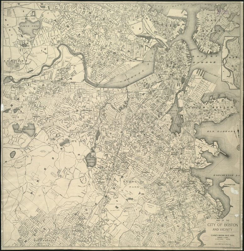
Map of the city of Boston and vicinity
Map of the city of Boston and vicinity
×
Item Information
Title:
Map of the city of Boston and vicinity
Date:
[ca. 1900]
Format:
Maps/Atlases
Location:
Boston Public Library
Norman B. Leventhal Map & Education Center
Collection (local):
Norman B. Leventhal Map & Education Center Collection
Subjects:
Boston (Mass.)--Maps
Places:
Massachusetts
>
Suffolk (county)
>
Boston
Extent:
1 map ; 68 x 66 cm.
Permalink:
https://ark.digitalcommonwealth.org/ark:/50959/cj82m220k
Terms of Use:
No known copyright restrictions.
No known restrictions on use.
Publisher:
Boston : Geo. H. Walker & Co.
Scale:
Scale 1:19,200.
Language:
English
Notes:
Oriented with north toward the upper left.
Includes inset of Breed's Island.
"Clark's Boston Blue Book."
Identifier:
06_01_004867
Call #:
G3764.B6 1900.2 .G4x
Barcode:
39999059008316
show more...
View MODS XML
More Like This
Annexation map
Atlas of the city of Boston : Boston proper : from actual surveys ...
Atlas of the city of Boston : Boston proper and Back Bay : from ...
Atlas of the city of Boston : Boston proper and Back Bay : from ...
Find More Like This >>
Tools
Share
Facebook
Pinterest
X
Reddit
Tumblr
Email
Copy link
Add to Folder
Questions/Comments
Cite This Item
IIIF Manifest
Downloads
Primary (full resolution, uncompressed)
(TIF, 156 MB)
Large (full resolution)
(JPEG, 13.1 MB)
Medium
(JPEG, 322 KB)