Skip to search
Skip to main content
Digital Commonwealth
Sign Up / Log In
Search for
Search
Search
Search
Basic
Advanced
Explore
Map
Collections
Institutions
Formats
For Educators
Primary Source Sets
Lesson Plans
Using Primary Sources
Searching Digital Commonwealth
For Institutions
Join Digital Commonwealth
Conferences, Trainings, & Events
How to Contribute Collections
Digitization Services
Board & Committees
Frequently Asked Questions
About
About Digital Commonwealth
News & Announcements
Copyright & Terms of Use
Harmful Content Statement
Partners
API
Contact Us
Boston Public Library
Norman B. Leventhal Map & Education Center Collection
/
Urban Maps (Collection of Distinction)
/
Boston and New England Maps (Collection of Distinction)
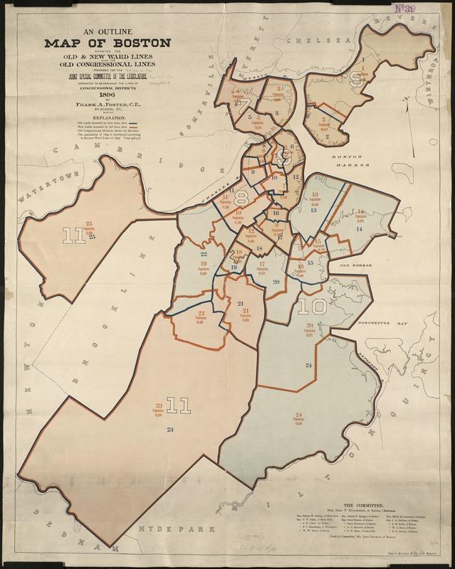
An outline map of Boston showing the old & new ward lines, also the old congressional lines
An outline map of Boston showing the old & new ward lines, also the old congressional lines
×
Item Information
Title:
An outline map of Boston showing the old & new ward lines, also the old congressional lines
Creator:
Massachusetts. General Court. Joint Special Committee on Congressional Redistricting
Draftsman:
Foster, Frank A.
Name on Item:
prepared for the Joint Special Committee of the Legislature appointed to rearrange the lines of the Congressional Districts ... by Frank A. Foster.
Date:
1896
Format:
Maps/Atlases
Location:
Boston Public Library
Norman B. Leventhal Map & Education Center
Collection (local):
Norman B. Leventhal Map & Education Center Collection
Subjects:
Boston (Mass.)--Administrative and political divisions--Maps
Places:
Massachusetts
>
Suffolk (county)
>
Boston
Extent:
1 map ; col. ; 89 x 69 cm.
Permalink:
https://ark.digitalcommonwealth.org/ark:/50959/js956j32c
Terms of Use:
No known copyright restrictions.
No known restrictions on use.
Publisher:
Boston : [s.n.]
Scale:
Scale not given.
Language:
English
Notes:
Oriented with north toward the upper left.
Shows population of each ward.
Identifier:
06_01_004726
Call #:
G3764.B6 1896 .M3
Barcode:
39999059007094
show more...
View MODS XML
More Like This
Map of Boston 1875 : from A. Williams & Cos. map of Boston and the ...
Map of Boston boundary line changes
Map of Boston showing new division of wards
Map of Boston showing proposed new division of wards Oct. 1875
Find More Like This >>
Tools
Share
Facebook
Pinterest
X
Reddit
Tumblr
Email
Copy link
Add to Folder
Questions/Comments
Cite This Item
IIIF Manifest
Downloads
Primary (full resolution, uncompressed)
(TIF, 211 MB)
Large (full resolution)
(JPEG, 17.7 MB)
Medium
(JPEG, 178 KB)