Skip to search
Skip to main content
Digital Commonwealth
Sign Up / Log In
Search for
Search
Search
Search
Basic
Advanced
Explore
Map
Collections
Institutions
Formats
For Educators
Primary Source Sets
Lesson Plans
Using Primary Sources
Searching Digital Commonwealth
For Institutions
Join Digital Commonwealth
Conferences, Trainings, & Events
How to Contribute Collections
Digitization Services
Board & Committees
Frequently Asked Questions
About
About Digital Commonwealth
News & Announcements
Copyright & Terms of Use
Harmful Content Statement
Partners
API
Contact Us
Boston Public Library
Norman B. Leventhal Map & Education Center Collection
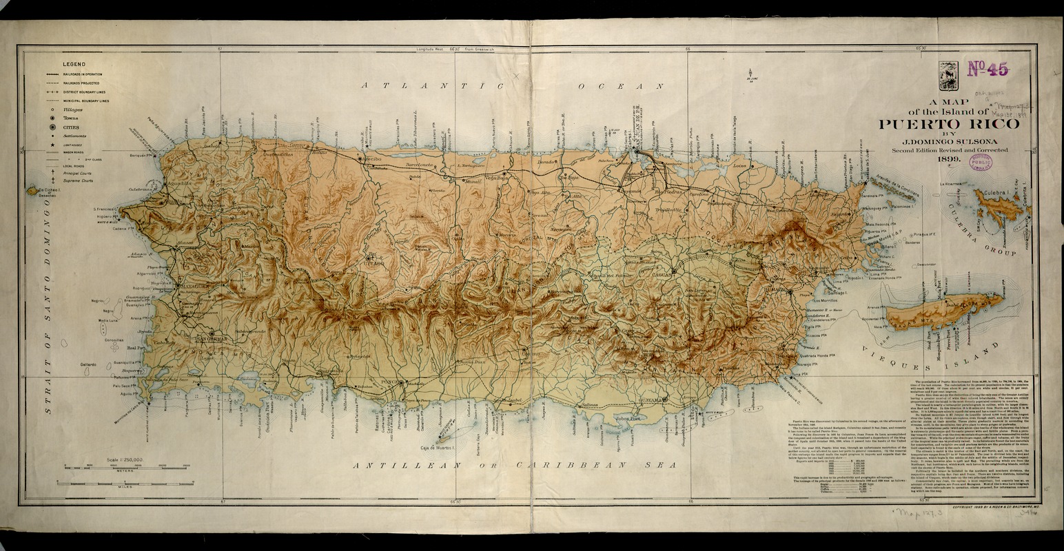
A map of the island of Puerto Rico
A map of the island of Puerto Rico
×
Item Information
Title:
A map of the island of Puerto Rico
Creator:
Sulsona, J. Domingo.
Name on Item:
by J. Domingo Sulsona.
Date:
[ca. 1899]
Format:
Maps/Atlases
Location:
Boston Public Library
Norman B. Leventhal Map & Education Center
Collection (local):
Norman B. Leventhal Map & Education Center Collection
Subjects:
Puerto Rico--Maps
Places:
Puerto Rico
(territory)
Extent:
1 map : col. ; 41 x 89 cm.
Permalink:
https://ark.digitalcommonwealth.org/ark:/50959/js956m36w
Terms of Use:
No known copyright restrictions.
No known restrictions on use.
Publisher:
Baltimore, Md : A. Hoen & Co.
Edition:
2nd ed. rev. and corr.
Scale:
Scale 1:250,000
Language:
English
Notes:
Political map.
Relief shown by shading.
Shows roads, railroads, etc.
Exhibited in “Faces and Places,” at the Boston Public Library, Boston, MA, October 2003 - September 2004. MB (BRL)
Identifier:
05_04_000024
Call #:
G4971.F1 1899 .S85
Barcode:
39999052507942
show more...
View MODS XML
More Like This
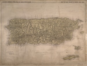
Military map, island of Puerto Rico
Outline map of Puerto Rico
Porto Rico and Virgin Isles : Haiti, Hispaniola or St. Domingo
Porto-Rico showing road work, light houses, rail roads, towns and ...
Find More Like This >>
Tools
Share
Facebook
Pinterest
X
Reddit
Tumblr
Email
Copy link
Add to Folder
Questions/Comments
Cite This Item
IIIF Manifest
Downloads
Primary (full resolution, uncompressed)
(TIF, 40.9 MB)
Large (full resolution)
(JPEG, 3.43 MB)
Medium
(JPEG, 451 KB)
GeoTIFF (georeferenced)
(TIF, 61.2 MB)