Skip to search
Skip to main content
Digital Commonwealth
Sign Up / Log In
Search for
Search
Search
Search
Basic
Advanced
Explore
Map
Collections
Institutions
Formats
For Educators
Primary Source Sets
Lesson Plans
Using Primary Sources
Searching Digital Commonwealth
For Institutions
Join Digital Commonwealth
Conferences, Trainings, & Events
How to Contribute Collections
Digitization Services
Board & Committees
Frequently Asked Questions
About
About Digital Commonwealth
News & Announcements
Copyright & Terms of Use
Harmful Content Statement
Partners
API
Contact Us
Boston Public Library
Norman B. Leventhal Map & Education Center Collection
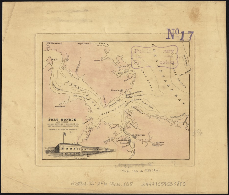
Fort Monroe and vicinity showing entrance to Chesapeake Bay, Norfolk, Portsmouth, Gosport Navy Yard &c
Fort Monroe and vicinity showing entrance to Chesapeake Bay, Norfolk, Portsmouth, Gosport Navy Yard &c
×
Item Information
Title:
Fort Monroe and vicinity showing entrance to Chesapeake Bay, Norfolk, Portsmouth, Gosport Navy Yard &c
Creator:
E.P. Dutton (Firm)
Date:
[1862]
Format:
Maps/Atlases
Location:
Boston Public Library
Norman B. Leventhal Map & Education Center
Collection (local):
Norman B. Leventhal Map & Education Center Collection
Subjects:
Harbors--Virginia--Fort Monroe--Maps
Fort Monroe (Va.)--Maps
Virginia--Maps
Places:
Virginia
>
Fortress Monroe
(defense installation)
Extent:
1 map : col., 15 x 18 cm.
Permalink:
https://ark.digitalcommonwealth.org/ark:/50959/kk91fr88r
Terms of Use:
No known copyright restrictions.
No known restrictions on use.
Scale:
Scale not given.
Language:
English
Notes:
Shows forts Monroe, Calhoun, Nelson, and Norfolk, Confederate batteries on Sewell's Point, towns, names of features.
Includes engraving: View of Fort Monroe.
This printing lacks roads.
Cf. LC Civil War Maps (2nd ed.), 546 for dif. printing.
Notes (date):
This date is inferred.
Identifier:
06_01_007388
Call #:
G3884.H2:2F6 1862 .D88
Barcode:
39999059030880
show more...
View MODS XML
More Like This
Map of Hampton Roads and Norfolk Harbor : showing the location of ...
Bacon's Map of the seat of war in Virginia : showing minutely the ...
Coast of North Carolina & Virginia
Colton's new topographical map of the states of Virginia, Maryland ...
Find More Like This >>
Tools
Share
Facebook
Pinterest
X
Reddit
Tumblr
Email
Copy link
Add to Folder
Questions/Comments
Cite This Item
IIIF Manifest
Downloads
Primary (full resolution, uncompressed)
(TIF, 103 MB)
Large (full resolution)
(JPEG, 8.65 MB)
Medium
(JPEG, 201 KB)