Skip to search
Skip to main content
Digital Commonwealth
Sign Up / Log In
Search for
Search
Search
Search
Basic
Advanced
Explore
Map
Collections
Institutions
Formats
For Educators
Primary Source Sets
Lesson Plans
Using Primary Sources
Searching Digital Commonwealth
For Institutions
Join Digital Commonwealth
Conferences, Trainings, & Events
How to Contribute Collections
Digitization Services
Board & Committees
Frequently Asked Questions
About
About Digital Commonwealth
News & Announcements
Copyright & Terms of Use
Harmful Content Statement
Partners
API
Contact Us
Boston Public Library
Norman B. Leventhal Map & Education Center Collection
/
David Judkins Weaver Papers
/
Boston and New England Maps (Collection of Distinction)
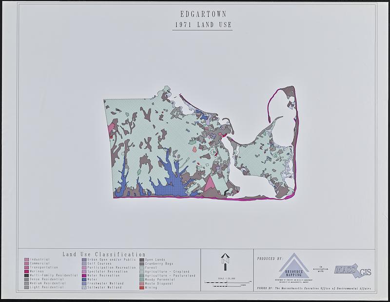
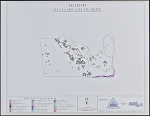
Edgartown 1971 to 1985 land use change
Viewing image 1 of 2
Next >
Edgartown 1971 to 1985 land use change
×
Next
Item Information
Title:
Edgartown 1971 to 1985 land use change
Cartographer:
University of Massachusetts (Amherst campus). Department of Forestry and Wildlife Management
Cartographer:
MassGIS (Office : Mass.)
Contributor:
Massachusetts. Executive Office of Environmental Affairs
Name on Item:
produced by Resource Mapping, Department of Forestry and Wildlife Management, University of Massachusetts, Amherst in association with MassGIS
Date:
1987–1991
Format:
Maps/Atlases
Location:
Boston Public Library
Norman B. Leventhal Map & Education Center
Collection (local):
David Judkins Weaver Papers
Subjects:
Edgartown (Mass. : Town)--Maps
Land use--Massachusetts--Edgartown (Town)--Maps
Places:
Massachusetts
>
Dukes (county)
>
Martha's Vineyard
(island)
>
Edgartown
Extent:
2 maps : color ; 83 x 103 cm
Permalink:
https://ark.digitalcommonwealth.org/ark:/50959/n5843676g
Terms of Use:
No known copyright restrictions.
No known restrictions on use.
Publisher:
[Amherst] : [Department of Forestry and Wildlife Management, University of Massachusetts, Amherst]
Scale:
Scale 1:25,000
Language:
English
Table of Contents:
1971 land use
1971 to 1985 land use change
Notes:
Likely lacking a third sheet showing 1985 land use.
Identifier:
06_01_018823A
06_01_018823B
Call #:
Weaver folder 9 no. 26-27
show more...
View MODS XML
More Like This
The 1976 proposed regional open space plan
Airbrush base for the Pelorus Linea region of Europa
Aitoff's equal area projection of the sphere
Antietam
Find More Like This >>
Tools
Share
Facebook
Pinterest
X
Reddit
Tumblr
Email
Copy link
Add to Folder
Questions/Comments
Cite This Item
IIIF Manifest
Downloads
Primary (full resolution, uncompressed)
(TIF, multi-file ZIP, 856 MB)
Large (full resolution)
(JPEG, multi-file ZIP, 6.83 MB)
Medium
(JPEG, multi-file ZIP, 128 KB)