Skip to search
Skip to main content
Digital Commonwealth
Sign Up / Log In
Search for
Search
Search
Search
Basic
Advanced
Explore
Map
Collections
Institutions
Formats
For Educators
Primary Source Sets
Lesson Plans
Using Primary Sources
Searching Digital Commonwealth
For Institutions
Join Digital Commonwealth
Conferences, Trainings, & Events
How to Contribute Collections
Digitization Services
Board & Committees
Frequently Asked Questions
About
About Digital Commonwealth
News & Announcements
Copyright & Terms of Use
Harmful Content Statement
Partners
API
Contact Us
Boston Public Library
Norman B. Leventhal Map & Education Center Collection
/
Urban Maps (Collection of Distinction)
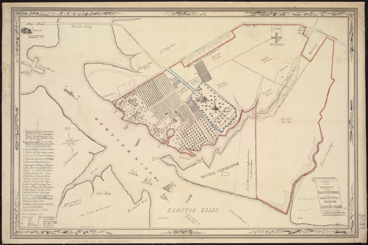
A plan of the property of the Hampton Normal and Agricultural Institute at Hampton Virginia
A plan of the property of the Hampton Normal and Agricultural Institute at Hampton Virginia
×
Item Information
Title:
A plan of the property of the Hampton Normal and Agricultural Institute at Hampton Virginia
Creator:
Semple, F. A.
Name on Item:
surveyed by F. A. Semple, C. S. ; S.C.A. del.
Date:
1876
Format:
Maps/Atlases
Location:
Boston Public Library
Norman B. Leventhal Map & Education Center
Collection (local):
Norman B. Leventhal Map & Education Center Collection
Subjects:
Hampton Normal and Agricultural Institute (Va.)--Maps
Land tenure--Virginia--Hampton--Maps
Hampton (Va.)--Maps
Places:
Virginia
>
Hampton
(independent city)
Hampton University
Extent:
1 map : hand col. ; 47 x 73 cm.
Permalink:
https://ark.digitalcommonwealth.org/ark:/50959/wd3762038
Terms of Use:
No known copyright restrictions.
No known restrictions on use.
Publisher:
New York : American Photo-Lithographic Company
Scale:
Scale not given.
Language:
English
Notes:
Shows street names, names of landowners, vegetation, drainage, and other points of interest.
Includes list of campus buildings.
Ills.: St. John's Church -- Chapel -- National Cemetery.
Identifier:
06_01_007411
Call #:
G3884.H2:2H3 1786 .S46
Barcode:
mq7064090
39999059031029
show more...
View MODS XML
More Like This
The 100th anniversary map of Abraham Lincoln's visit to ...
1630 shoreline
1879. Progress map of the U.S. Geographical Surveys west of the ...
1903 Map of Salem and surrounding places
Find More Like This >>
Tools
Share
Facebook
Pinterest
X
Reddit
Tumblr
Email
Copy link
Add to Folder
Questions/Comments
Cite This Item
IIIF Manifest
Downloads
Primary (full resolution, uncompressed)
(TIF, 204 MB)
Large (full resolution)
(JPEG, 17.2 MB)
Medium
(JPEG, 289 KB)
We'd love your feedback!
×
Would you be interested in taking a short survey about Digital Commonwealth?