Skip to search
Skip to main content
Digital Commonwealth
Sign Up / Log In
Search for
Search
Search
Search
Basic
Advanced
Explore
Map
Collections
Institutions
Formats
For Educators
Primary Source Sets
Lesson Plans
Using Primary Sources
Searching Digital Commonwealth
For Institutions
Join Digital Commonwealth
Conferences, Trainings, & Events
How to Contribute Collections
Digitization Services
Board & Committees
Frequently Asked Questions
About
About Digital Commonwealth
News & Announcements
Copyright & Terms of Use
Harmful Content Statement
Partners
API
Contact Us
Boston Public Library
Norman B. Leventhal Map & Education Center Collection
/
Boston and New England Maps (Collection of Distinction)
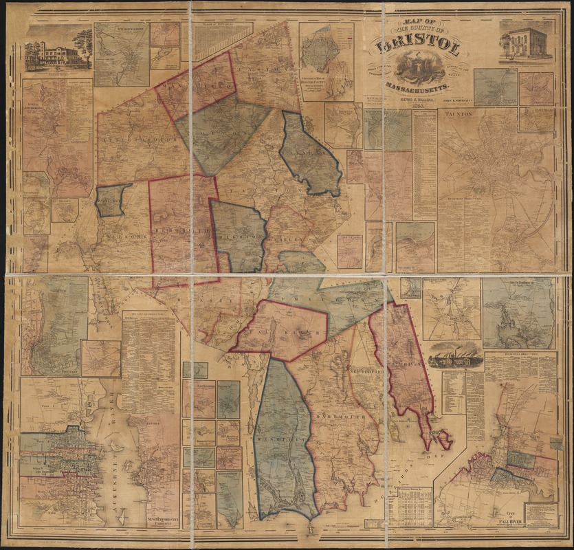
Map of the county of Bristol, Massachusetts : based upon the trigonometrical survey of the state
Map of the county of Bristol, Massachusetts
×
Item Information
Title:
Map of the county of Bristol, Massachusetts : based upon the trigonometrical survey of the state
Creator:
Walling, Henry Francis, 1825-1888
Name on Item:
the details from actual surveys under the direction of Henry F. Walling ; engraved, printed, colored & mounted at H.F. Wallings Map Establishment.
Date:
1858
Format:
Maps/Atlases
Location:
Boston Public Library
Norman B. Leventhal Map & Education Center
Collection (local):
Norman B. Leventhal Map & Education Center Collection
Subjects:
Real property--Massachusetts--Bristol County--Maps
Bristol County (Mass.)--Maps
Places:
Massachusetts
>
Bristol (county)
Extent:
1 map : col. ; 152 x 150 cm.
Permalink:
https://ark.digitalcommonwealth.org/ark:/50959/wd376642s
Terms of Use:
No known copyright restrictions.
No known restrictions on use.
Publisher:
New York : John L. Smith & Co.
Scale:
Scale [1:47,520]. 240 rods to an in.
Language:
English
Notes:
Relief shown by hachures.
Includes inset maps of each town, illustrations of buildings, business directories and a geological map of the county.
Identifier:
06_01_002639
Call #:
G3763.B7 1858 .W3
Barcode:
39999058996537
LCCN:
87691359
show more...
View MODS XML
More Like This
Atlas of Bristol Co., Massachusetts : from actual surveys
New topographical atlas of surveys Bristol County, Massachusetts
Map of Bristol County Massachusetts : based on the trigonometrical ...
Atlas of Massachusetts
Find More Like This >>
Tools
Share
Facebook
Pinterest
X
Reddit
Tumblr
Email
Copy link
Add to Folder
Questions/Comments
Cite This Item
IIIF Manifest
Downloads
Primary (full resolution, uncompressed)
(TIF, 704 MB)
Large (full resolution)
(JPEG, 59.2 MB)
Medium
(JPEG, 298 KB)
We'd love your feedback!
×
Would you be interested in taking a short survey about Digital Commonwealth?