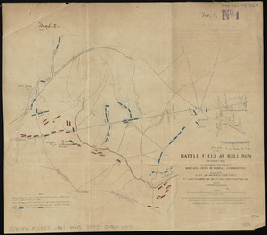
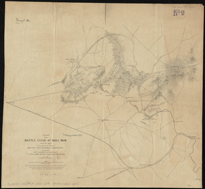
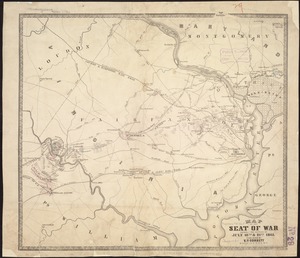
Map of the battlefield of Bull Run, Virginia. Brig. Gen. Irvin McDowell commanding the U.S. forces, Gen. [P.] G.T. Beauregard commanding the Confederate forces, July 21st 1861
Map of the battlefield of Bull Run, Virginia. Brig. Gen. Irvin McDowell commanding the U.S. forces, Gen. [P.] G.T. Beauregard commanding the Confederate forces, July 21st 1861
Item Information
Title:
Map of the battlefield of Bull Run, Virginia. Brig. Gen. Irvin McDowell commanding the U.S. forces, Gen. [P.] G.T. Beauregard commanding the Confederate forces, July 21st 1861
Compiled from a map accompanying the report of Brig. Genl. McDowell and a map made under the direction of Genl. Beauregard. Published by authority of the Hon. the Secretary of War in the office of the Chief of Engineers, U.S. Army.
Gives roads, railroads, hachures, vegetation, drainage, villages, houses, fences, and names of residents. "Dotted lines near Centreville indicate sites of [Union] bivouacs on the night of July 20th. Full lines denote the position of the forces on the next day at the commencement of the engagement at Sudley's Springs; blue marking the United States Forces, and red the Confederates."
Description derived from published bibliography.
![Map of the battlefield of Bull Run, Virginia. Brig. Gen. Irvin McDowell commanding the U.S. forces, Gen. [P.] G.T. Beauregard commanding the Confederate forces, July 21st 1861](https://bpldcassets.blob.core.windows.net/derivatives/images/commonwealth:ww72bp023/image_access_800.jpg)