Skip to search
Skip to main content
Digital Commonwealth
Sign Up / Log In
Search for
Search
Search
Search
Basic
Advanced
Explore
Map
Collections
Institutions
Formats
For Educators
Primary Source Sets
Lesson Plans
Using Primary Sources
Searching Digital Commonwealth
For Institutions
Join Digital Commonwealth
Conferences, Trainings, & Events
How to Contribute Collections
Digitization Services
Board & Committees
Frequently Asked Questions
About
About Digital Commonwealth
News & Announcements
Copyright & Terms of Use
Harmful Content Statement
Partners
API
Contact Us
Boston Public Library
Norman B. Leventhal Map & Education Center Collection
/
Urban Maps (Collection of Distinction)
/
Boston and New England Maps (Collection of Distinction)
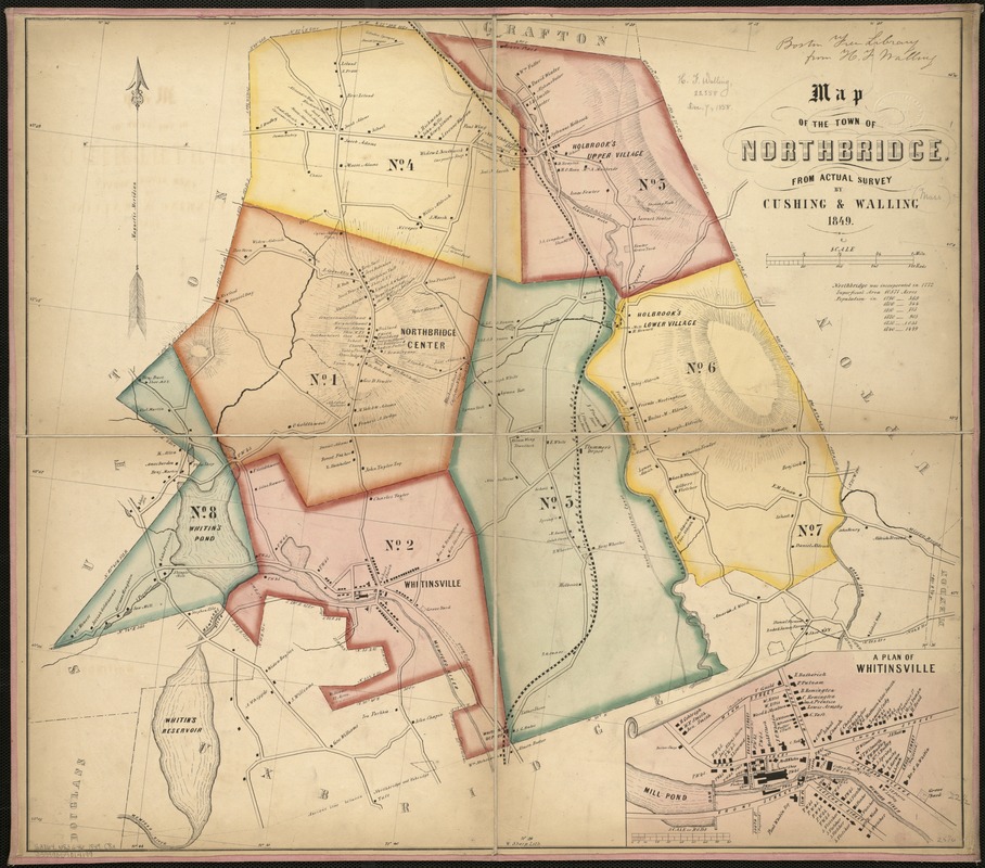
Map of the town of Northbridge : from actual survey
Map of the town of Northbridge
×
Item Information
Title:
Map of the town of Northbridge : from actual survey
Creator:
Cushing, S. B. (Samuel B.)
Name on Item:
by Cushing & Walling.
Date:
[1849]
Format:
Maps/Atlases
Location:
Boston Public Library
Norman B. Leventhal Map & Education Center
Collection (local):
Norman B. Leventhal Map & Education Center Collection
Subjects:
Landowners--Massachusetts--Northbridge--Maps
Landowners--Massachusetts--Whitinsville--Maps
Northbridge (Mass. : Town)--Maps
Whitinsville (Mass.)--Maps
Places:
Massachusetts
>
Worcester (county)
>
Northbridge Center
Massachusetts
>
Worcester (county)
>
Northbridge
>
Whitinsville
Extent:
1 map : col. ; 57 x 64 cm.
Permalink:
https://ark.digitalcommonwealth.org/ark:/50959/x059cb62n
Terms of Use:
No known copyright restrictions.
No known restrictions on use.
Publisher:
S.l : s.n.
Scale:
Scale 1:253,440.
Language:
English
Notes:
Relief shown by hachures.
Inset: A plan of Whitinsville.
Notes (date):
This date is inferred.
Identifier:
06_01_005425
Call #:
G3764.N83G46 1849 .C8x
Barcode:
39999059014199
show more...
View MODS XML
More Like This
Atlas of the boundaries of the city of Worcester and towns of ...
The 100th anniversary map of Abraham Lincoln's visit to ...
1630 shoreline
1879. Progress map of the U.S. Geographical Surveys west of the ...
Find More Like This >>
Tools
Share
Facebook
Pinterest
X
Reddit
Tumblr
Email
Copy link
Add to Folder
Questions/Comments
Cite This Item
IIIF Manifest
Downloads
Primary (full resolution, uncompressed)
(TIF, 125 MB)
Large (full resolution)
(JPEG, 10.5 MB)
Medium
(JPEG, 265 KB)