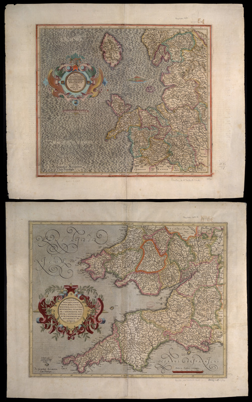
West Morlandia, Lancastria, Cestria, Caernarvan, Denbigh, Flint, Meridionidh, Montgomery, Salpia, cum Insulis Mania et Anglesey ; Cornubia, Davonia, Somersetus, Dorcestria, Wiltonia, Glocestria, Monumetha, Glamorgan, Caermarden, Pembroke, Cardigan, Radnor
West Morlandia, Lancastria, Cestria, Caernarvan, Denbigh, Flint, Meridionidh, Montgomery, Salpia, cum Insulis Mania et Anglesey ; Cornubia, Davonia, Somersetus, Dorcestria, Wiltonia, Glocestria, Monumetha, Glamorgan, Caermarden, Pembroke, Cardigan, Radnor
Item Information
Title:
West Morlandia, Lancastria, Cestria, Caernarvan, Denbigh, Flint, Meridionidh, Montgomery, Salpia, cum Insulis Mania et Anglesey ; Cornubia, Davonia, Somersetus, Dorcestria, Wiltonia, Glocestria, Monumetha, Glamorgan, Caermarden, Pembroke, Cardigan, Radnor
Title (alt.):
West Morlandia, Lancastria, Cestria, Caernarvan, Denbigh, Flint, Meridionidh, Montgomery, Salpia, cum Insulis Mania et Anglesey
Cornubia, Davonia, Somersetus, Dorcestria, Wiltonia, Glocestria, Monumetha, Glamorgan, Caermarden, Pembroke, Cardigan, Radnor, Breknoke, Herefordia, & Wigornia
Description:
These two maps, portraying portions of Cornwall and Wales, were originally prepared by Gerard Mercator, one of the greatest of early Dutch map makers. These two atlas sheets were published in either the 1628 or 1633 French edition of Mercator and Jodocus Hondius's ''Atlas''. Originally published in 1595, this book of maps was the first such publication to use the term atlas to describe a collection of published maps. The use of this term is often associated with the Greek Titan, Atlas, who was condemned by Zeus to carry the heavens and earth on his shoulders for all time.