Skip to search
Skip to main content
Digital Commonwealth
Sign Up / Log In
Search for
Search
Search
Search
Basic
Advanced
Explore
Map
Collections
Institutions
Formats
For Educators
Primary Source Sets
Lesson Plans
Using Primary Sources
Searching Digital Commonwealth
For Institutions
Join Digital Commonwealth
Conferences, Trainings, & Events
How to Contribute Collections
Digitization Services
Board & Committees
Frequently Asked Questions
About
About Digital Commonwealth
News & Announcements
Copyright & Terms of Use
Harmful Content Statement
Partners
API
Contact Us
Boston Public Library
Norman B. Leventhal Map & Education Center Collection
/
David Judkins Weaver Papers
/
Boston and New England Maps (Collection of Distinction)
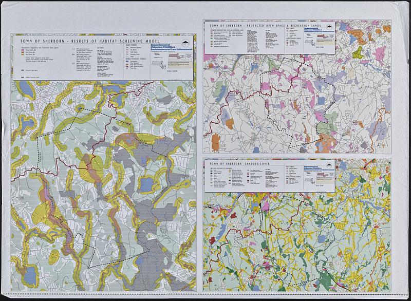
Town of Sherborn protected open space and land use
Town of Sherborn protected open space and land use
×
Item Information
Title:
Town of Sherborn protected open space and land use
Cartographer:
Massachusetts. Department of Fisheries, Wildlife, and Environmental Law Enforcement
Contributor:
MassGIS (Office : Mass.)
Cartographer:
Massachusetts. Executive Office of Environmental Affairs
Name on Item:
produced by DFWELE GIS program
Date:
1994
Format:
Maps/Atlases
Location:
Boston Public Library
Norman B. Leventhal Map & Education Center
Collection (local):
David Judkins Weaver Papers
Subjects:
Sherborn (Mass. : Town)--Maps
Land use--Massachusetts--Sherborn (Town)--Maps
Recreation--Massachusetts--Sherborn (Town)--Maps
Open spaces--Massachusetts--Sherborn (Town)--Maps
Protected areas--Massachusetts--Sherborn (Town)--Maps
Places:
Massachusetts
>
Middlesex (county)
>
Sherborn
Extent:
3 maps on 1 sheet : color ; 80 x 58 and 42 x 58 cm, on sheet 92 x 126 cm
Permalink:
https://ark.digitalcommonwealth.org/ark:/50959/xg94p4582
Terms of Use:
No known copyright restrictions.
No known restrictions on use.
Publisher:
[Boston] : Massachusetts Executive Office of Environmental Affairs
Scale:
Scale 1:18,000
Scale 1:32,000
Language:
English
Table of Contents:
Town of Sherborn - results of habitat screening model
Town of Sherborn - protected open space & recreation lands
Town of Sherborn - landuse/cover
Notes:
Includes location map.
Identifier:
06_01_018819
Call #:
Weaver folder 9 no. 19
show more...
View MODS XML
More Like This
The 1976 proposed regional open space plan
Airbrush base for the Pelorus Linea region of Europa
Aitoff's equal area projection of the sphere
Antietam
Find More Like This >>
Tools
Share
Facebook
Pinterest
X
Reddit
Tumblr
Email
Copy link
Add to Folder
Questions/Comments
Cite This Item
IIIF Manifest
Downloads
Primary (full resolution, uncompressed)
(TIF, 638 MB)
Large (full resolution)
(JPEG, 53.6 MB)
Medium
(JPEG, 150 KB)