Skip to search
Skip to main content
Digital Commonwealth
Sign Up / Log In
Search for
Search
Search
Search
Basic
Advanced
Explore
Map
Collections
Institutions
Formats
For Educators
Primary Source Sets
Lesson Plans
Using Primary Sources
Searching Digital Commonwealth
For Institutions
Join Digital Commonwealth
Conferences, Trainings, & Events
How to Contribute Collections
Digitization Services
Board & Committees
Frequently Asked Questions
About
About Digital Commonwealth
News & Announcements
Copyright & Terms of Use
Harmful Content Statement
Partners
API
Contact Us
American Antiquarian Society
American Revolutionary War-Era Maps (Collection of Distinction)
/
American Antiquarian Society Collection
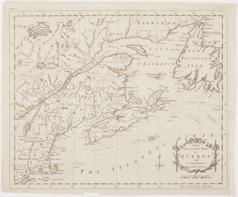
A new and accurate map of Quebec and its boundaries: from a late survey
A new and accurate map of Quebec and its boundaries: from a late survey
×
Item Information
Title:
A new and accurate map of Quebec and its boundaries: from a late survey
Description:
Subject: Map of the province of Quebec, including Labrador and Newfoundland, Nova Scotia, and part of New England.
Date:
[1781]
Format:
Maps/Atlases
Location:
American Antiquarian Society
Collection (local):
American Antiquarian Society Collection
Subjects:
Canada--Maps
Québec (Province)--Maps
New England--Maps
Places:
New England
(area)
Canada
>
Quebec
(province)
Extent:
1 map : engraving ; 27 x 33 cm., on sheet 29 x 35 cm.
Permalink:
https://ark.digitalcommonwealth.org/ark:/50959/z603vg80x
Terms of Use:
Public Domain/No known restrictions on use. Contact host institution to download image.
Contact host institution for more information.
Publisher:
London : [s.n.]
Scale:
Scale [ca. 1:5,068,800]
Language:
English
Referenced by:
http://catalog.mwa.org/vwebv/holdingsInfo?bibId=479006
Notes:
Relief shown by hachures.
From the Universal magazine, September, 1781.
Notes (date):
This date is inferred.
show more...
View MODS XML
More Like This
An Exact map of the province of Quebec with part of New York & New ...
L'Isle de Terre-Neuve, l'Acadie, ou la Nouvelle Ecosse, : l'Isle ...
A Map of that part of America which was the principal seat of war ...
Map of the Eastern Railroad and principal connections
Find More Like This >>
Tools
Share
Facebook
Pinterest
X
Reddit
Tumblr
Email
Copy link
Add to Folder
Questions/Comments
Cite This Item
IIIF Manifest