Skip to search
Skip to main content
Skip to first result
Digital Commonwealth
Folders
Sign Up / Log In
Search for
Search
Search
Search
Basic
Advanced
Explore
Map
Collections
Institutions
Formats
For Educators
Primary Source Sets
Lesson Plans
Using Primary Sources
Searching Digital Commonwealth
For Institutions
Join Digital Commonwealth
Conferences, Trainings, & Events
How to Contribute Collections
Digitization Services
Board & Committees
Frequently Asked Questions
About
About Digital Commonwealth
News & Announcements
Copyright & Terms of Use
Harmful Content Statement
Partners
API
Contact Us
Search
Search Constraints
Start Over
Save Search
Your search:
More Like
commonwealth:1257c3536
✖
Remove constraint More Like: commonwealth:1257c3536
« Prev.
|
10,921
-
10,940
of
11,688
|
Next »
Sort
by relevance
relevance
title
date (asc)
date (desc)
Number of results to display per page
20
per page
per page
10
per page
20
per page
50
per page
100
per page
View results as:
List
list view
Maps
map view
Gallery
grid view
Search Results
10921.
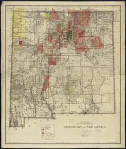
Territory of New Mexico
10922.
Territory of New Mexico
10923.
Territory of Utah
10924.
Territory of Utah
10925.
Territory of Wyoming
10926.
The territory over possession of which France and England are disputing
10927.
Tertia Affrice tabula continet Cyrenainaycam & Egyptum cum adiacentibus insulis
10928.
Tertia Africae tabula
10929.
Tertia Asiae tabula
10930.
Tertia Asie tabula continet Colchide, Iberia, Albania :& maiorem Armenia
10931.
Tertia Europae tabula
10932.
Teton National Forest, Wyoming
10933.
Tetrachia Ducatus Geldriae Neomagensis
10934.
Tetrachia ducatus Geldriae Ruremondana sive Hispanica
10935.
A Texan's map of the United States [of Texas]
10936.
Texas and Pacific Rail Way
10937.
Texas New Yorker travelers' railroad map of the State of Texas
10938.
Texas New Yorker's railroad map of Texas : showing all completed and proposed routes, with principal rivers, county boundaries...
10939.
Tezanos Pinto (Entre Rios)
10940.
[The natural shape of England with the names of rivers, seaports, sands, hills, moors, forrests, and many other remarks which...
« Previous
Next »
1
2
…
543
544
545
546
547
548
549
550
551
…
584
585
Limit your search
Subject
Real property--Massachusetts--Boston--Maps
2,355
Boston (Mass.)--Maps
2,181
Landowners--Massachusetts--Boston--Maps
2,153
Roxbury (Boston, Mass.)--Maps
363
Dorchester (Boston, Mass.)--Maps
325
Cambridge (Mass.)--Maps
268
Brookline (Mass.)--Maps
237
Real property--Massachusetts--Cambridge--Maps
216
more
Subject
»
Place
North and Central America
8,977
United States
7,899
Massachusetts
5,060
Suffolk (county)
3,642
Boston
3,502
Europe
1,359
Middlesex (county)
620
Canada
448
more
Place
»
Format
Maps/Atlases
11,629
Manuscripts
215
Prints
56
Books
35
Objects/Artifacts
10
Drawings/Illustrations
8
Posters
4
Available to use
No known restrictions
11,489
Creative Commons license
67
Date
View distribution
Current results range from
1482
to
2023
Date range begin
Date range end
View larger »
Unknown
4
Collection
Norman B. Leventhal Map & Education Center Collection
11,412
Boston and New England Maps (Collection of Distinction)
5,307
Urban Maps (Collection of Distinction)
5,037
Maritime Charts and Atlases (Collection of Distinction)
1,081
American Revolutionary War-Era Maps (Collection of Distinction)
625
Boston Redevelopment Authority Collection
253
Historic Maps
49
Massachusetts Real Estate Atlases
38
more
Collection
»
Institution
Boston Public Library
11,557
State Library of Massachusetts
52
Salem State University Archives and Special Collections
49
Private Collection
20
American Antiquarian Society
9
Boston Athenaeum
1


![A Texan's map of the United States [of Texas]](https://bpldcassets.blob.core.windows.net/derivatives/images/commonwealth:fn107c388/image_thumbnail_300.jpg)


