Skip to search
Skip to main content
Skip to first result
Digital Commonwealth
Folders
Sign Up / Log In
Search for
Search
Search
Search
Basic
Advanced
Explore
Map
Collections
Institutions
Formats
For Educators
Primary Source Sets
Lesson Plans
Using Primary Sources
Searching Digital Commonwealth
For Institutions
Join Digital Commonwealth
Conferences, Trainings, & Events
How to Contribute Collections
Digitization Services
Board & Committees
Frequently Asked Questions
About
About Digital Commonwealth
News & Announcements
Copyright & Terms of Use
Harmful Content Statement
Partners
API
Contact Us
Search
Search Constraints
Start Over
Save Search
Your search:
More Like
commonwealth:2227nj07w
✖
Remove constraint More Like: commonwealth:2227nj07w
« Prev.
|
641
-
660
of
726
|
Next »
Sort
by relevance
relevance
title
date (asc)
date (desc)
recently added
Number of results to display per page
20
per page
per page
10
per page
20
per page
50
per page
100
per page
View results as:
List
list view
Maps
map view
Gallery
grid view
Search Results
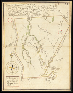
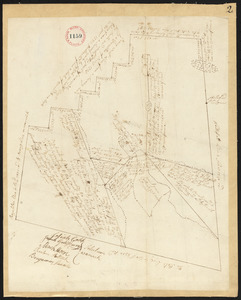
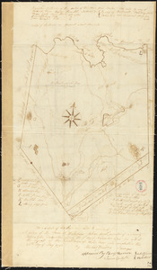
641.
Plan of Warren surveyed by Rufus B Copeland, dated April 21, 1795.
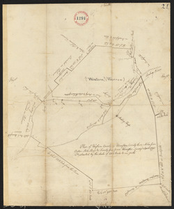
642.
Plan of Warren (Western), surveyor's name not given, dated April 1795.
643.
Plan of Warren (Western), surveyor's name not given, dated October 24, 1831
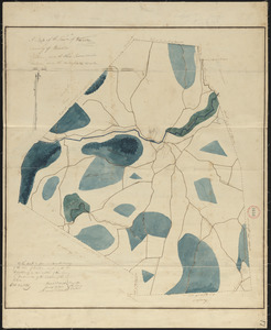
644.
Plan of Warwick made by Jonathan Blake, Jr., dated 1830
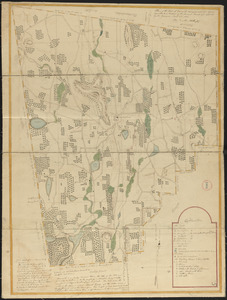
645.
Plan of Warwick, surveyor's name not given, dated November 1794.
646.
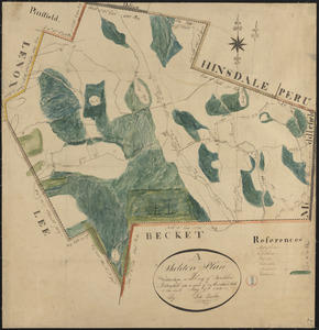
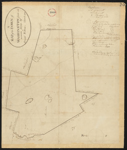
Plan of Washington made by Luke Barber, dated May 9, 1831
647.
Plan of Washington, surveyor's name not given, dated March 1795.
648.
Plan of Waterborough surveyed by Michel Bowden dated May 26, 1795.
649.
Plan of Waterford surveyed by Nathaniel Chamberlin, dated December 29, 1795.
650.
Plan of Watertown and Waltham surveyed by Abner Sanderson, dated 1795.
651.
Plan of Watertown made by John G. Hales, dated June 1830
652.
Plan of Wayland (East Sudbury) made by William C Grout, dated March, 1831
653.
Plan of Wayne, surveyor's name not given. Endorsement reads New Sandwich or No.1 Plantation, Lincoln. Received January 18, 1796.
654.
Plan of Webster, surveyor's name not given, dated 1830
655.
Plan of Wellfleet made by John G. Hales, dated 1831
656.
Plan of Wellfleet made by Oliver Arey, dated 1841
657.
Plan of Wellfleet, surveyor's name not given, dated May 1795.
658.
Plan of Wells, made by Ralph Wheelwright, dated November 1794.
659.
Plan of Wendell, surveyor's name not given, dated January 1, 1795.
660.
Plan of Wendell, surveyor's name not given, dated October 1830
« Previous
Next »
1
2
…
29
30
31
32
33
34
35
36
37
Limit your search
Place
North and Central America
724
United States
723
Massachusetts
296
Maine
128
Worcester (county)
109
Middlesex (county)
76
Franklin (county)
61
Berkshire (county)
59
more
Place
»
Format
Maps/Atlases
726
Available to use
No known restrictions
726
Date
View distribution
Current results range from
1786
to
1898
Date range begin
Date range end
View larger »
Collection
Town plans, 1794
402
Town plans, 1830
324
Institution
Massachusetts Archives
726
We'd love your feedback!
×
Would you be interested in taking a short survey about Digital Commonwealth?