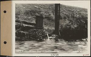
19781. Ware River, stream gage at Coldbrook, 30, Coldbrook, Oakham, Mass., Jun. 8, 1928 Creator: Massachusetts. Metropolitan District Water Supply Commission; Chetwynd, Charles B., 1906-1994 Format: Photographs Collection: Massachusetts Metropolitan District Water Supply Commission, Quabbin Reservoir, Photographs of Real Estate, Sanitary Conditions, and Flooding in the Ware River Watershed, and of General Engineering, 1928-1948 Date: June 8, 1928 Institution: Massachusetts Archives
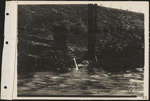
19782. Ware River stream, slope gage at Coldbrook, Coldbrook, Barre, Mass., Jun. 8, 1928 Creator: Massachusetts. Metropolitan District Water Supply Commission; Chetwynd, Charles B., 1906-1994 Format: Photographs Collection: Massachusetts Metropolitan District Water Supply Commission, Quabbin Reservoir, Photographs of Real Estate, Sanitary Conditions, and Flooding in the Ware River Watershed, and of General Engineering, 1928-1948 Date: June 8, 1928 Institution: Massachusetts Archives
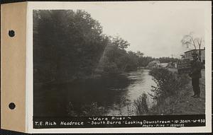
19783. Ware River, T.E. Rich headrace, South Barre, looking downstream, Barre, Mass., 10:30 AM, Oct. 20, 1932 Creator: Massachusetts. Metropolitan District Water Supply Commission; Pike, Stuart D., 1910-1978 Format: Photographs Collection: Massachusetts Metropolitan District Water Supply Commission, Quabbin Reservoir, Photographs of Real Estate, Sanitary Conditions, and Flooding in the Ware River Watershed, and of General Engineering, 1928-1948 Date: October 20, 1932 Institution: Massachusetts Archives
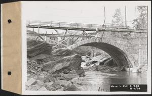
19784. Ware River, temporary foot bridge on East Street, Ware, Mass., Oct. 3, 1938 Creator: Massachusetts. Metropolitan District Water Supply Commission Format: Photographs Collection: Massachusetts Metropolitan District Water Supply Commission, Quabbin Reservoir, Photographs of Real Estate, Sanitary Conditions, and Flooding in the Ware River Watershed, and of General Engineering, 1928-1948 Date: October 3, 1938 Institution: Massachusetts Archives
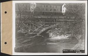
19785. Ware River, temporary foot bridge on East Street, Ware, Mass., Oct. 3, 1938 Creator: Massachusetts. Metropolitan District Water Supply Commission Format: Photographs Collection: Massachusetts Metropolitan District Water Supply Commission, Quabbin Reservoir, Photographs of Real Estate, Sanitary Conditions, and Flooding in the Ware River Watershed, and of General Engineering, 1928-1948 Date: October 3, 1938 Institution: Massachusetts Archives
19786. Ware River, temporary foot bridge on East Street, Ware, Mass., Oct. 3, 1938 Creator: Massachusetts. Metropolitan District Water Supply Commission Format: Photographs Collection: Massachusetts Metropolitan District Water Supply Commission, Quabbin Reservoir, Photographs of Real Estate, Sanitary Conditions, and Flooding in the Ware River Watershed, and of General Engineering, 1928-1948 Date: October 3, 1938 Institution: Massachusetts Archives
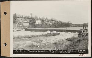
19787. Ware River, Thorndike Lower Dam and pond, looking upstream, Thorndike, Palmer, Mass., 2:20 PM, Apr. 1, 1932 Creator: Massachusetts. Metropolitan District Water Supply Commission; Pike, Stuart D., 1910-1978 Format: Photographs Collection: Massachusetts Metropolitan District Water Supply Commission, Quabbin Reservoir, Photographs of Real Estate, Sanitary Conditions, and Flooding in the Ware River Watershed, and of General Engineering, 1928-1948 Date: April 1, 1932 Institution: Massachusetts Archives
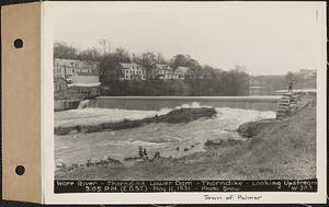
19788. Ware River, Thorndike Lower Dam, Thorndike, looking upstream, Ware River, Palmer, Mass., 3:05 PM (E.D.S.T.), May 11, 1931 Creator: Massachusetts. Metropolitan District Water Supply Commission; Snow, Russell, 1902-1969 Format: Photographs Collection: Massachusetts Metropolitan District Water Supply Commission, Quabbin Reservoir, Photographs of Real Estate, Sanitary Conditions, and Flooding in the Ware River Watershed, and of General Engineering, 1928-1948 Date: May 11, 1931 Institution: Massachusetts Archives
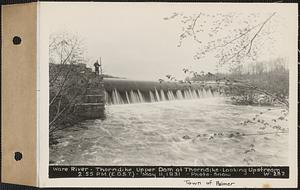
19789. Ware River, Thorndike Upper Dam at Thorndike, looking upstream, Ware River, Palmer, Mass., 2:55 PM (E.D.S.T.), May 11, 1931 Creator: Massachusetts. Metropolitan District Water Supply Commission; Snow, Russell, 1902-1969 Format: Photographs Collection: Massachusetts Metropolitan District Water Supply Commission, Quabbin Reservoir, Photographs of Real Estate, Sanitary Conditions, and Flooding in the Ware River Watershed, and of General Engineering, 1928-1948 Date: May 11, 1931 Institution: Massachusetts Archives
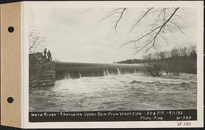
19790. Ware River, Thorndike Upper Dam from west side, Thorndike, Palmer, Mass., 2:08 PM, Apr. 1, 1932 Creator: Massachusetts. Metropolitan District Water Supply Commission; Pike, Stuart D., 1910-1978 Format: Photographs Collection: Massachusetts Metropolitan District Water Supply Commission, Quabbin Reservoir, Photographs of Real Estate, Sanitary Conditions, and Flooding in the Ware River Watershed, and of General Engineering, 1928-1948 Date: April 1, 1932 Institution: Massachusetts Archives
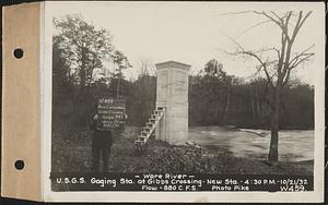
19791. Ware River, United States Geological Survey (U.S.G.S.) Gaging Station at Gibbs Crossing, new station, flow = 880 cubic feet per second, Thorndike, Palmer, Mass., 4:30... Creator: Massachusetts. Metropolitan District Water Supply Commission; Pike, Stuart D., 1910-1978 Format: Photographs Collection: Massachusetts Metropolitan District Water Supply Commission, Quabbin Reservoir, Photographs of Real Estate, Sanitary Conditions, and Flooding in the Ware River Watershed, and of General Engineering, 1928-1948 Date: October 21, 1932 Institution: Massachusetts Archives
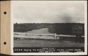
19792. Ware River, United States Geological Survey (U.S.G.S.) Gaging Station at Gibbs Crossing, old station, flow = 880 cubic feet per second, Thorndike, Palmer, Mass., 4:00... Creator: Massachusetts. Metropolitan District Water Supply Commission; Pike, Stuart D., 1910-1978 Format: Photographs Collection: Massachusetts Metropolitan District Water Supply Commission, Quabbin Reservoir, Photographs of Real Estate, Sanitary Conditions, and Flooding in the Ware River Watershed, and of General Engineering, 1928-1948 Date: October 21, 1932 Institution: Massachusetts Archives
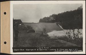
19793. Ware River, upper dam, George H. Gilbert Co., looking south, flow approximately 860 cubic feet per second, Barre, Mass., 2:20 PM, Oct. 20, 1932 Creator: Massachusetts. Metropolitan District Water Supply Commission; Pike, Stuart D., 1910-1978 Format: Photographs Collection: Massachusetts Metropolitan District Water Supply Commission, Quabbin Reservoir, Photographs of Real Estate, Sanitary Conditions, and Flooding in the Ware River Watershed, and of General Engineering, 1928-1948 Date: October 20, 1932 Institution: Massachusetts Archives
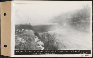
19794. Ware River, upper dam, Gilbertville, Hardwick, Mass., 3:05 PM, Mar. 12, 1936 Creator: Massachusetts. Metropolitan District Water Supply Commission; Pike, Stuart D., 1910-1978 Format: Photographs Collection: Massachusetts Metropolitan District Water Supply Commission, Quabbin Reservoir, Photographs of Real Estate, Sanitary Conditions, and Flooding in the Ware River Watershed, and of General Engineering, 1928-1948 Date: March 12, 1936 Institution: Massachusetts Archives
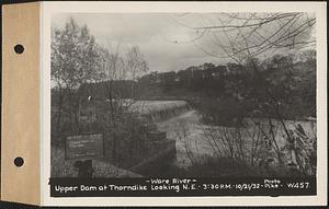
19795. Ware River, upper dam, looking northeast, Thorndike, Palmer, Mass., 3:30 PM, Oct. 21, 1932 Creator: Massachusetts. Metropolitan District Water Supply Commission; Pike, Stuart D., 1910-1978 Format: Photographs Collection: Massachusetts Metropolitan District Water Supply Commission, Quabbin Reservoir, Photographs of Real Estate, Sanitary Conditions, and Flooding in the Ware River Watershed, and of General Engineering, 1928-1948 Date: October 21, 1932 Institution: Massachusetts Archives
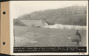
19796. Ware River, upper dam of George H. Gilbert Manufacturing Co., drainage area = 161 square miles, flow = 1650 cubic feet per second = 10.2 cubic feet per second per... Creator: Massachusetts. Metropolitan District Water Supply Commission; Pike, Stuart D., 1910-1978 Format: Photographs Collection: Massachusetts Metropolitan District Water Supply Commission, Quabbin Reservoir, Photographs of Real Estate, Sanitary Conditions, and Flooding in the Ware River Watershed, and of General Engineering, 1928-1948 Date: April 13, 1934 Institution: Massachusetts Archives
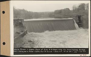
19797. Ware River, upper dam of George H. Gilbert Manufacturing Co., from highway bridge, drainage area = 161 square miles, flow = 1650 cubic feet per second = 10.2 cubic... Creator: Massachusetts. Metropolitan District Water Supply Commission; Pike, Stuart D., 1910-1978 Format: Photographs Collection: Massachusetts Metropolitan District Water Supply Commission, Quabbin Reservoir, Photographs of Real Estate, Sanitary Conditions, and Flooding in the Ware River Watershed, and of General Engineering, 1928-1948 Date: April 13, 1934 Institution: Massachusetts Archives
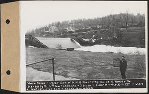
19798. Ware River, upper dam of G.H. Gilbert Manufacturing Co. at Gilbertville, drainage area = 161 square miles, flow 1250 cubic feet per second = 7.8 cubic feet per second... Creator: Massachusetts. Metropolitan District Water Supply Commission; Pike, Stuart D., 1910-1978 Format: Photographs Collection: Massachusetts Metropolitan District Water Supply Commission, Quabbin Reservoir, Photographs of Real Estate, Sanitary Conditions, and Flooding in the Ware River Watershed, and of General Engineering, 1928-1948 Date: April 3, 1933 Institution: Massachusetts Archives
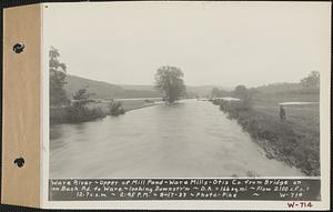
19799. Ware River, upper end of mill pond, Ware Mills Otis Co. from bridge on back road to Ware, looking downstream, drainage area = 166 square miles, flow = 2100 cubic feet... Creator: Massachusetts. Metropolitan District Water Supply Commission; Pike, Stuart D., 1910-1978 Format: Photographs Collection: Massachusetts Metropolitan District Water Supply Commission, Quabbin Reservoir, Photographs of Real Estate, Sanitary Conditions, and Flooding in the Ware River Watershed, and of General Engineering, 1928-1948 Date: September 17, 1933 Institution: Massachusetts Archives
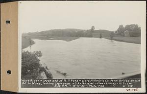
19800. Ware River, upper end of mill pond, Ware Mills Otis Co. from bridge on back road to Ware, looking upstream, drainage area = 166 square miles, flow = 2100 cubic feet... Creator: Massachusetts. Metropolitan District Water Supply Commission; Pike, Stuart D., 1910-1978 Format: Photographs Collection: Massachusetts Metropolitan District Water Supply Commission, Quabbin Reservoir, Photographs of Real Estate, Sanitary Conditions, and Flooding in the Ware River Watershed, and of General Engineering, 1928-1948 Date: September 17, 1933 Institution: Massachusetts Archives