1. Stanford's shilling map of the seat of war Creator: Stanford, Edward, 1827-1904 Format: Maps/Atlases Collection: Norman B. Leventhal Map & Education Center Collection Date: 1870 Institution: Boston Public Library
2. Battle of Gravelotte, August 18th, 1870 Creator: Hozier, H. M. (Henry Montague), 1842-1907, Walker, Robert, and Mackenzie, William (Publisher) Format: Maps/Atlases Collection: Norman B. Leventhal Map & Education Center Collection Date: [1870] Institution: Boston Public Library
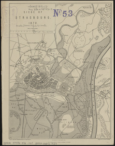
3. Siege of Strasbourg, 1870 Creator: Hozier, H. M. (Henry Montague), 1842-1907, Walker, Robert, and Mackenzie, William (Publisher) Format: Maps/Atlases Collection: Norman B. Leventhal Map & Education Center Collection Date: [1872] Institution: Boston Public Library
4. Siege of Strasbourg, 1870 : enlarged sketch of works Creator: Hozier, H. M. (Henry Montague), 1842-1907, Walker, Robert, and Mackenzie, William (Publisher) Format: Maps/Atlases Collection: Norman B. Leventhal Map & Education Center Collection Date: [1870] Institution: Boston Public Library
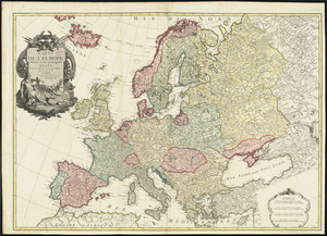
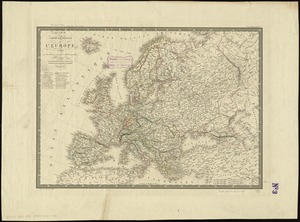
5. An accurate map of Europe from the best authorities Creator: Carey, Mathew, 1760-1839; Hill, Samuel, approximately 1766-1804 Format: Maps/Atlases Collection: Norman B. Leventhal Map & Education Center Collection Date: [1800] Institution: Boston Public Library
6. Angling in troubled waters = der fischfang im truben = la peche en eau trouble = la pesca nelle acque turbes : a serio-comic map of Europe Creator: Rose, Fredk. W. (Frederick W.) Format: Maps/Atlases Collection: Norman B. Leventhal Map & Education Center Collection Date: [ca. 1899] Institution: Boston Public Library
7. Bacon's large scale shilling map of seat of war from Paris to Berlin, and the Baltic Creator: G.W. Bacon & Co. Format: Maps/Atlases Collection: Norman B. Leventhal Map & Education Center Collection Date: [1870] Institution: Boston Public Library
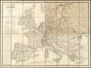
8. Bacon's map of Europe Creator: G.W. Bacon & Co Format: Maps/Atlases Collection: Norman B. Leventhal Map & Education Center Collection Date: 1870 Institution: Boston Public Library
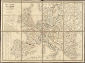
9. Bacon's map of Europe Creator: G.W. Bacon & Co Format: Maps/Atlases Collection: Norman B. Leventhal Map & Education Center Collection Date: [1860?–1869?] Institution: Boston Public Library
10. Bacon's map of Europe Creator: G.W. Bacon & Co Format: Maps/Atlases Collection: Norman B. Leventhal Map & Education Center Collection Date: [1860?–1869?] Institution: Boston Public Library
11. Bacon's military map of Central Europe, in bold print for tracing the movements of the armies Creator: G.W. Bacon & Co. Format: Maps/Atlases Collection: Norman B. Leventhal Map & Education Center Collection Date: [1870] Institution: Boston Public Library
12. Bacon's new shilling war map Paris to Berlin Creator: G.W. Bacon & Co. Format: Maps/Atlases Collection: Norman B. Leventhal Map & Education Center Collection Date: [1870] Institution: Boston Public Library
13. Blackwood's map of the seat of war Creator: James Blackwood & Co. Format: Maps/Atlases Collection: Norman B. Leventhal Map & Education Center Collection Date: [1870] Institution: Boston Public Library
14. Bradshaw's map of Europe shewing the railways opened and in progress Creator: Adams, William James, active 1841-1874; Bradshaw & Blacklock Format: Maps/Atlases Collection: Norman B. Leventhal Map & Education Center Collection Date: [1871–1872] Institution: Boston Public Library
15. Carte de l'Europe divisée en ses principaux états Creator: Bonne, Rigobert, 1727-1794, Bonne, Rigobert, 1727-1794, and Lattré, Jean Format: Maps/Atlases Collection: Norman B. Leventhal Map & Education Center Collection Date: 1779 Institution: Boston Public Library
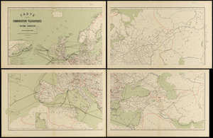
16. Carte des communications télégraphiques du régime européen Creator: International Telegraph Bureau (Bern, Switzerland); Van Hoven, C. Format: Maps/Atlases Collection: Norman B. Leventhal Map & Education Center Collection Date: 1898 Institution: Boston Public Library
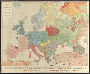
17. Carte ethnographique de l'Europe Creator: Gabrys-Paršaitis, Juozas, 1880-1951, Librairie Centrale des Nationalités, and Kümmerly + Frey Format: Maps/Atlases Collection: Norman B. Leventhal Map & Education Center Collection Date: 1918 Institution: Boston Public Library
18. Carte générale de l'Europe, en 1824 Creator: Brué, Adrien Hubert, 1786-1832 Format: Maps/Atlases Collection: Norman B. Leventhal Map & Education Center Collection Date: 1824 Institution: Boston Public Library
19. Carte itinéraire de l'Europe indiquant les limites actuelles des etats : dediée au Roi Creator: Dufour, A.-H. (Auguste-Henri), 1798-1865 Format: Maps/Atlases Collection: Norman B. Leventhal Map & Education Center Collection Date: 1835 Institution: Boston Public Library
20. Carte itinéraire de l'Europe indiquant les limites actuelles des etats : dédiée au Roi Creator: Dufour, A.-H. (Auguste-Henri), 1798-1865 Format: Maps/Atlases Collection: Norman B. Leventhal Map & Education Center Collection Date: 1848 Institution: Boston Public Library