Skip to search
Skip to main content
Skip to first result
Digital Commonwealth
Folders
Sign Up / Log In
Search for
Search
Search
Search
Basic
Advanced
Explore
Map
Collections
Institutions
Formats
For Educators
Primary Source Sets
Lesson Plans
Using Primary Sources
Searching Digital Commonwealth
For Institutions
Join Digital Commonwealth
Conferences, Trainings, & Events
How to Contribute Collections
Digitization Services
Board & Committees
Frequently Asked Questions
About
About Digital Commonwealth
News & Announcements
Copyright & Terms of Use
Harmful Content Statement
Partners
API
Contact Us
Search
Search Constraints
Start Over
Save Search
Your search:
More Like
commonwealth:5138jp13m
✖
Remove constraint More Like: commonwealth:5138jp13m
« Prev.
|
1,381
-
1,400
of
1,457
|
Next »
Sort
by relevance
relevance
title
date (asc)
date (desc)
recently added
Number of results to display per page
20
per page
per page
10
per page
20
per page
50
per page
100
per page
View results as:
List
list view
Maps
map view
Gallery
grid view
Search Results
1381.
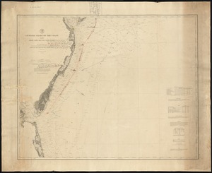
General chart of the coast, No. IV, from Cape May to Cape Henry
1382.
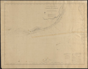
General chart of the coast, Straits of Florida
1383.
General chart of the South Atlantic or [illegible]iopic Ocean [illegible] the Equator to 65° south latitude [illegible]ng to...
1384.
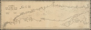
Geo. W. Eldridge's chart A, Long Island Sound from New York to New London
1385.
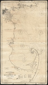
Geo. W. Eldridge's chart D, Massachusetts Bay and the coast from Chatham to Boston and Gloucester
1386.
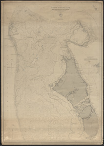
The Great Bahama Bank
1387.
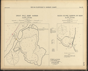
Great Salt Pond Harbor, west side of Block Island, R.I. ; Block Island Harbor, or basin, east side of Block Island, R.I.
1388.
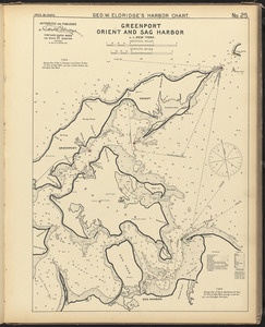
Greenport, Orient, and Sag Harbor, L.I., New York
1389.
Greenwich and Apponaug, R.I. ; Wickford, R.I.
1390.
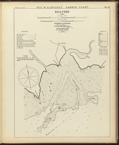
Guilford, Conn.
1391.
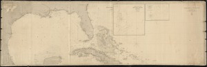
Gulf of Mexico, West Indies, and Caribbean Sea
1392.
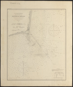
Hatteras Shoals
1393.
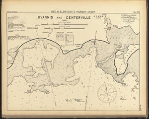
Hyannis and Centerville, Mass.
1394.
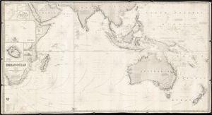
Indian Ocean
1395.
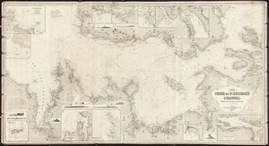
The Irish or St. George's Channel
1396.
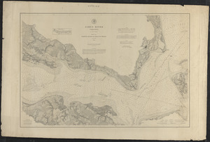
James River, Virginia, sheet no. 1, Hampton Roads to point of shoals
1397.
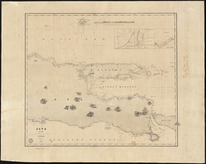
Java
1398.
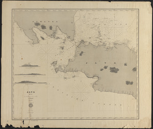
Java, blad I
1399.
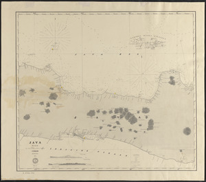
Java, blad II
1400.
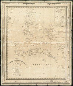
Kaart der Moluksche Eilanden en Vaarwaters, benevens een blad met verchillende plannen volgens de laatste Hydrographische...
« Previous
Next »
1
2
…
66
67
68
69
70
71
72
73
Limit your search
Subject
Coastlines
892
Bays (Bodies of water)
469
Bodies of water
247
Boats
212
Houses
185
Beaches
130
Rivers
112
Harbors
102
more
Subject
»
Place
North and Central America
1,077
United States
1,033
Massachusetts
748
Barnstable (county)
281
Essex (county)
172
Europe
152
Yarmouth
106
Maine
90
more
Place
»
Format
Photographs
754
Postcards/Cards
315
Prints
237
Maps/Atlases
180
Paintings
13
Posters
12
Drawings/Illustrations
11
Albums/Scrapbooks
3
more
Format
»
Available to use
Creative Commons license
638
No known restrictions
473
Date
View distribution
Current results range from
1764
to
2001
Date range begin
Date range end
View larger »
Unknown
1
Collection
Historical Society of Old Yarmouth Archives and Local History Collection
232
Nautical Chart Collection of the Chatham Historical Society
167
American Artists
122
Tichnor Brothers Postcard Collection
110
Bill Lane Photograph Collection
107
Charles H. Woodbury (1864-1940). Prints, Drawings, Watercolors, Oil Paintings, and Copper Plates
64
Nicholas Catsimpoolas Collection
57
Leslie Jones Collection
55
more
Collection
»
Institution
Boston Public Library
625
Historical Society of Old Yarmouth
244
Atwood Museum of the Chatham Historical Society
167
Newburyport Public Library
107
Phillips Library at the Peabody Essex Museum
61
Griffin Museum of Photography
51
Thomas Crane Public Library
42
Martha's Vineyard Museum
35
more
Institution
»
![General chart of the South Atlantic or [illegible]iopic Ocean [illegible] the Equator to 65° south latitude [illegible]ng to the latest surveys & observations](https://bpldcassets.blob.core.windows.net/derivatives/images/commonwealth:n87107022/image_thumbnail_300.jpg)