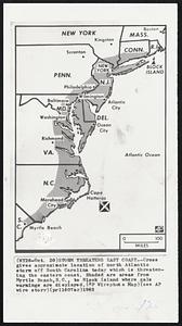
181. Storm Threatens East Coast--Cross gives approximate location of north Atlantic storm off South Carolina today which is threatening the eastern coast. Shaded are areas... Creator: Associated Press Format: Photographs Collection: Boston Herald-Traveler Photo Morgue Date: [ca. October 1963] Institution: Boston Public Library
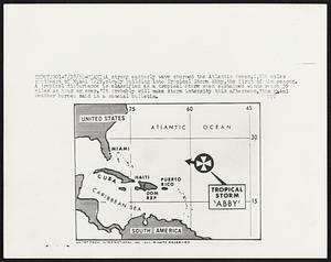
182. A strong easterly wave churned the Atlantic Ocean,1,500 miles southeast of Miami 7/29,slowly building into Tropical Storm Abby,the first of the season. A tropical... Creator: United Press International Format: Photographs Collection: Boston Herald-Traveler Photo Morgue Date: [ca. July 1964] Institution: Boston Public Library
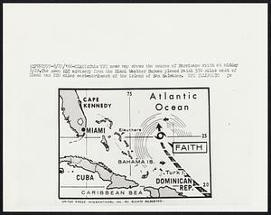
183. This UPI news map shows the course of Hurricane Faith at midday 8/29. The Noon EDT advisory from the Miami Weather Bureau placed Faith 570 miles east of Miami and 220... Creator: United Press International Format: Photographs Collection: Boston Herald-Traveler Photo Morgue Date: [ca. August 1966] Institution: Boston Public Library
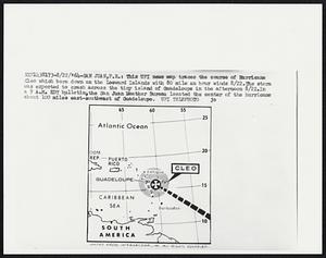
184. This UPI news map traces the course of Hurricane Cleo which bore down on the Leeward Islands with 80 mile an hour winds 8/22. The storm was expected to crash across... Creator: United Press International Format: Photographs Collection: Boston Herald-Traveler Photo Morgue Date: [ca. August 1964] Institution: Boston Public Library
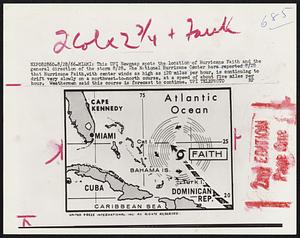
185. This UPI Newsmap spots the location of Hurricane Faith and the general direction of the storm 8/28. The National Hurricane Center here reported 8/28 that Hurricane... Creator: United Press International Format: Photographs Collection: Boston Herald-Traveler Photo Morgue Date: [ca. August 1966] Institution: Boston Public Library
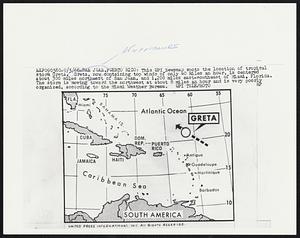
186. This UPI Newsmap spots the location of tropical storm Greta. Greta, now containing top winds of only 40 miles an hour, is centered about 300 miles northeast of San... Creator: United Press International Format: Photographs Collection: Boston Herald-Traveler Photo Morgue Date: [ca. September 1966] Institution: Boston Public Library
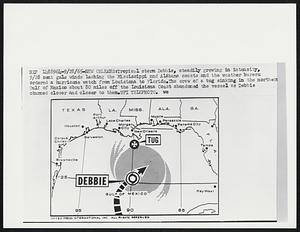
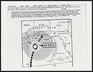
187. Tropical storm Debbie, steadily growing in intensity, 9/29 sent gale winds lashing the Mississippi and Alabama coasts and the weather bureau ordered a hurricane watch... Creator: United Press International Format: Photographs Collection: Boston Herald-Traveler Photo Morgue Date: [ca. September 1965] Institution: Boston Public Library
188. Tropical Storm Debbie,bearing 50 mile-an-hour winds, clawed the hurricane-tortured Gulf coast 9/28 with tides and winds and caused the evacuation of more than 750... Creator: United Press International Format: Photographs Collection: Boston Herald-Traveler Photo Morgue Date: [ca. September 1965] Institution: Boston Public Library
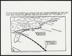
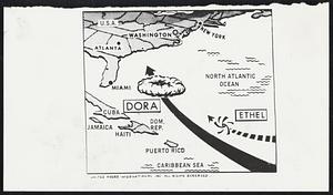
189. Tropical storm Dora, packing 65 miles-per-hour winds, moved up the South Carolina coast 9/13 just inland from shore. Weather forecasters said Dora would likely regain... Creator: United Press International Format: Photographs Collection: Boston Herald-Traveler Photo Morgue Date: [ca. September 1964] Institution: Boston Public Library
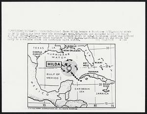
190. Tropical Storm Hilda became a Hurricane 9/30, packing winds up to 80 miles per hour near the center. At noon, EDT, Hilda was centered about 450 miles south of Biloxi,... Creator: United Press International Format: Photographs Collection: Boston Herald-Traveler Photo Morgue Date: [ca. September 1964] Institution: Boston Public Library
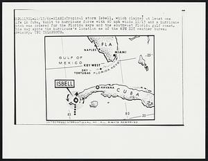
191. Tropical storm Isbell, which claimed at least one life in Cuba, built to hurricane force with 80 mph winds 10/13 and a hurricane watch was ordered for the Florida keys... Creator: United Press International Format: Photographs Collection: Boston Herald-Traveler Photo Morgue Date: [ca. October 1964] Institution: Boston Public Library
192. Weather - Hurricane Creator: Associated Press Format: Photographs Collection: Boston Herald-Traveler Photo Morgue Date: [ca. 1948] Institution: Boston Public Library
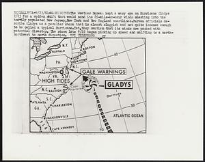
193. The Weather Bureau kept a wary eye on Hurricane Gladys 9/23 for a sudden shift that would send its 85-mile-an-hour winds slashing into the heavily populated New... Creator: United Press International Format: Photographs Collection: Boston Herald-Traveler Photo Morgue Date: [ca. September 1964] Institution: Boston Public Library
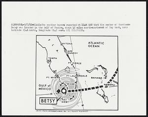
194. The weather bureau reported at 11AM EST that the center of Hurricane Betsy was located in the Gulf of Mexico, about 45 miles north-northeast of Key West, near latitude... Creator: United Press International Format: Photographs Collection: Boston Herald-Traveler Photo Morgue Date: [ca. September 1965] Institution: Boston Public Library
195. Weather Hurricane Maps Creator: United Press International Format: Photographs Collection: Boston Herald-Traveler Photo Morgue Date: [ca. September 1964] Institution: Boston Public Library
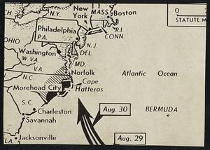
196. Where Betsy Is Heading -- Cross and arrow indicate present location and direction Hurricane Betsy was heading today as an intense and dangerous storm with top winds of... Creator: Associated Press Format: Photographs Collection: Boston Herald-Traveler Photo Morgue Date: [ca. September 1965] Institution: Boston Public Library
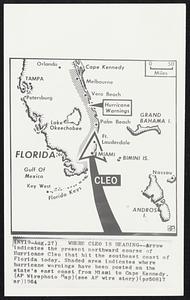
197. Where Cleo Is Heading--Arrow indicates the present northward course of Hurricane Cleo that hit the southeast coast of Florida today. Shaded area indicates where... Creator: Associated Press Format: Photographs Collection: Boston Herald-Traveler Photo Morgue Date: [ca. August 1964] Institution: Boston Public Library
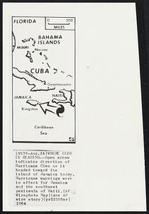
198. Where Cleo Is Heading--Open arrow indicates direction of Hurricane Cleo as it headed toward the island of Jamaica today. Hurricane warnings were in effect for Jamaica... Creator: Associated Press Format: Photographs Collection: Boston Herald-Traveler Photo Morgue Date: [ca. August 1964] Institution: Boston Public Library
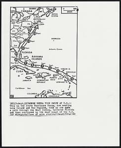
199. Where Donna Took Swipe At U.S. -- This is the route Hurricane Donna, now nearing Los Island and New England, took as she made a path through the West Indies, battered... Creator: Associated Press Format: Photographs Collection: Boston Herald-Traveler Photo Morgue Date: [ca. September 1960] Institution: Boston Public Library
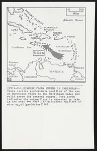
200. Where Flora Churns in Caribbean--Cross locates approximate position of the eye of Hurricane Flora in the Caribbean today and solid arrow its present course. Open arrow... Creator: Associated Press Format: Photographs Collection: Boston Herald-Traveler Photo Morgue Date: [ca. October 1963] Institution: Boston Public Library