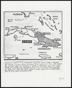
201. Where Flora Devastated Cuba--Map locates Cuba's Camaguey and Oriente provinces where Hurricane Flora caused more than 1,000 deaths and material losses of million of... Creator: Associated Press Format: Photographs Collection: Boston Herald-Traveler Photo Morgue Date: [ca. October 1963] Institution: Boston Public Library
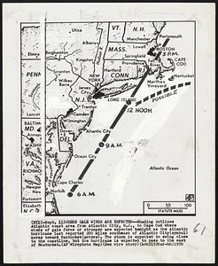
202. Where Gale Winds are Expected--Shading outlines Atlantic coast area from Atlantic City, N.J., to Cape Cod where winds of gale force or stronger are expected tonight as... Creator: Associated Press Format: Photographs Collection: Boston Herald-Traveler Photo Morgue Date: [ca. September 1950] Institution: Boston Public Library
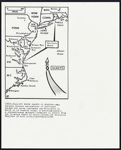
203. Where Gladys Is Heading--Map locates present whereabouts of Hurricane iladys and arrow indicates the direction in which 1t lay heading today. A hurricane watch-- a... Creator: Associated Press Format: Photographs Collection: Boston Herald-Traveler Photo Morgue Date: [ca. September 1964] Institution: Boston Public Library
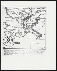
204. Where Hilda Hits Louisiana--Map gives approximate location of Hurricane Hilda which smashed the deserted Louisiana coast today. A tornado whipping ahead of Hilda’s... Creator: Associated Press Format: Photographs Collection: Boston Herald-Traveler Photo Morgue Date: [ca. October 1964] Institution: Boston Public Library
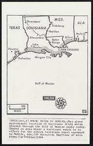
205. Where Hilda Is Moving--Map gives approximate location of Hurricane Hilda which churned through the Gulf of Mexico early today. Shaded is area where a hurricane watch... Creator: Associated Press Format: Photographs Collection: Boston Herald-Traveler Photo Morgue Date: [ca. October 1964] Institution: Boston Public Library
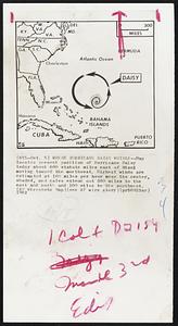
206. Where Hurricane Daisy Whirls--Map locates present position of Hurricane Daisy today about 600 statute miles east of Miami moving toward the morthwest. Highest winds... Creator: Associated Press Format: Photographs Collection: Boston Herald-Traveler Photo Morgue Date: [ca. October 1962] Institution: Boston Public Library
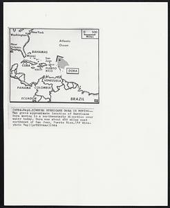
207. Where Hurricane Dora is Moving--Map gives approximate location of Hurricane Dora moving in a northwesterly direction over water today. Dora was about 450 miles east... Creator: Associated Press Format: Photographs Collection: Boston Herald-Traveler Photo Morgue Date: [ca. September 1964] Institution: Boston Public Library
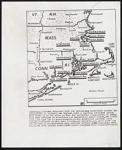
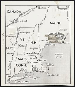
208. Where Hurricane Hits New England-Map underlines hardest hit communities in southern New England, where a snarling hurricane struck with winds up to 100 miles an hour... Creator: Associated Press Format: Photographs Collection: Boston Herald-Traveler Photo Morgue Date: [ca. August 1951] Institution: Boston Public Library
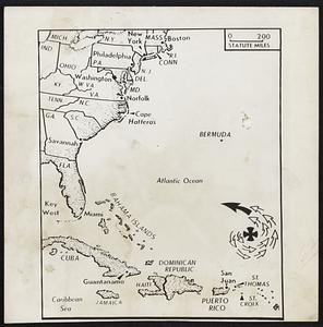
209. Where Hurricane Lurks-Center of a hurricane (cross) described as a “real whizzer” by the federal storm warning service, with winds of 80 to 100 miles an hour, was... Creator: Associated Press Format: Photographs Collection: Boston Herald-Traveler Photo Morgue Date: [ca. August 1948] Institution: Boston Public Library
210. Where Nazi Spies Landed--Located above (submarine symbol) is Hancock Point, Frenchman Bay, on the Maine coast where two German agents were landed from a submarine Nov.... Creator: Associated Press Format: Photographs Collection: Boston Herald-Traveler Photo Morgue Date: [ca. January 1945] Institution: Boston Public Library
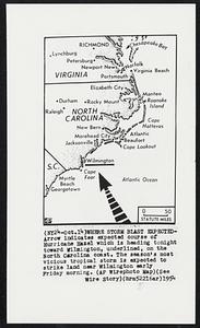
211. Where Storm Blast Expected- Arrow indicates expected course of Hurricane Hazel which is heading tonight toward Wilmington, underlined, on the North Carolina coast. The... Creator: Associated Press Format: Photographs Collection: Boston Herald-Traveler Photo Morgue Date: [ca. October 1954] Institution: Boston Public Library
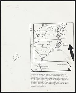
212. Where Storm Seems Headed--Arrow indicates reported general direction of Hurricane Esther. Hurricane warnings were raised today along North Carolina coast,northward to... Creator: Associated Press Format: Photographs Collection: Boston Herald-Traveler Photo Morgue Date: [ca. September 1961] Institution: Boston Public Library
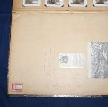
213. Print, Photographic Format: Photographs Collection: Big Book Date: 1885–1940 Institution: Arlington Historical Society
214. Adding the aArtistic Touch - Plaster models are made from the cardboard negatives and then are retouched by expert modellers to add accuracy and remove the step-like... Creator: Fay Foto Service (Boston, Mass.) Format: Photographs Collection: Boston Herald-Traveler Photo Morgue Date: [ca. June 1938] Institution: Boston Public Library
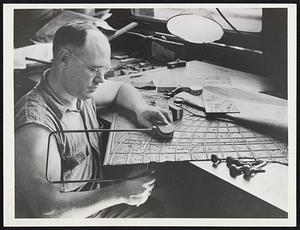
215. Aerial Map Making -- A Painstaking Job. Here the prints are laid out on a huge board to be matched together. Each is numbered so that it can be easily fitted into... Creator: Wide World Photos, Inc. Format: Photographs Collection: Boston Herald-Traveler Photo Morgue Date: [ca. December 1937] Institution: Boston Public Library
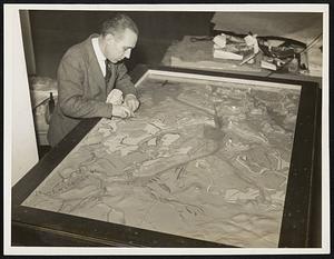
216. Boston Bureau tech professor completes relief map of Boston Harbor: Prof. Arthur C. Watson of M. I. T. who has been working at Harvard College, School of Geography,... Creator: Wide World Photos, Inc. Format: Photographs Collection: Boston Herald-Traveler Photo Morgue Date: [ca. March 1938] Institution: Boston Public Library
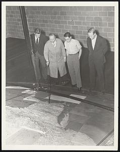
217. Dr. Wallace Atwood, director of the map construction, points to the location of the Custom's House tower as three Institute students look on. Left to right: Neil... Creator: Fay Foto Service (Boston, Mass.) Format: Photographs Collection: Boston Herald-Traveler Photo Morgue Date: [ca. June 1938] Institution: Boston Public Library
218. Dr. Wallace W. Atwood, geographer from Clark University finish huge relief map at Babson Institute Format: Photographs Collection: Boston Herald-Traveler Photo Morgue Date: [ca. January 1941] Institution: Boston Public Library
219. Following the Battle-Line - Sophie Goldberg and Bridie O'Connell, left to right, study one of the war maps on display in the vestibule of the Boston Public Library,... Format: Photographs Collection: Boston Herald-Traveler Photo Morgue Date: [ca. October 1941] Institution: Boston Public Library
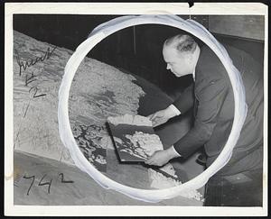
220. A foundryman is shown in the circle sawing out a section of an original plate preliminary to such an insertion. Creator: Wide World Photos, Inc. Format: Photographs Collection: Boston Herald-Traveler Photo Morgue Date: [ca. December 1938] Institution: Boston Public Library