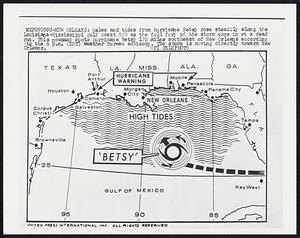
161. New Orleans: Gales and tides from hurricane Betsy rose steadily along the Louisiana-Mississippi gulf coast 9/9 as the full fury of the storm came in at a dead run.... Creator: United Press International Format: Photographs Collection: Boston Herald-Traveler Photo Morgue Date: [ca. September 1954] Institution: Boston Public Library
162. New Orleans: New Orleans and Baton Rouge, La., dug out from the devastation of Hurricane Betsy 9/10 as the storm dropped out of the Hurricane class and headed north... Creator: United Press International Format: Photographs Collection: Boston Herald-Traveler Photo Morgue Date: [ca. September 1965] Institution: Boston Public Library
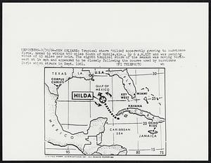
163. New Orleans: Tropical storm “Hilda,” apparently growing to hurricane force, moved to within 450 miles South of Mobile, Ala., by 6 A.M. EDT and was packing winds of 65... Creator: United Press International Format: Photographs Collection: Boston Herald-Traveler Photo Morgue Date: [ca. September 1964] Institution: Boston Public Library
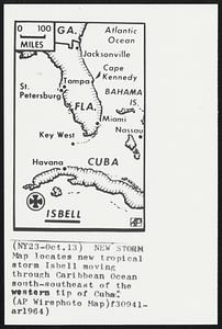
164. New Storm Map locates new tropical storm Isbell moving through Caribbean Ocean south-southeast of the western tip of Cuba. Creator: Associated Press Format: Photographs Collection: Boston Herald-Traveler Photo Morgue Date: [ca. October 1964] Institution: Boston Public Library
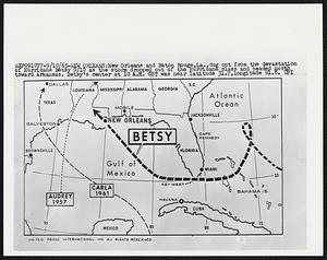
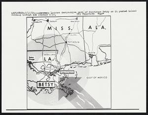
165. Newsmap locates destructive path of Hurricane Betsy as it pushed inland cutting through New Orleans. Creator: United Press International Format: Photographs Collection: Boston Herald-Traveler Photo Morgue Date: [ca. September 1965] Institution: Boston Public Library
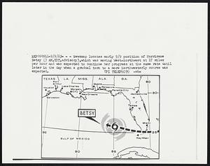
166. Newsmap locates early 9/9 position of Hurricane Betsy (3 AM, EDT, advisory), which was moving West-Northwest at 17 miles per hour and was expected to continue her... Creator: United Press International Format: Photographs Collection: Boston Herald-Traveler Photo Morgue Date: [ca. September 1965] Institution: Boston Public Library
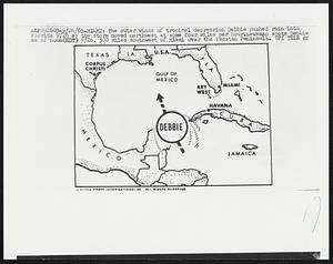
167. The outer winds of tropical depression Debbie pushed rain into Florida 9/26 as the storm moved northwest at some four miles per hour.Newsmap spots Debbie as of... Creator: United Press International Format: Photographs Collection: Boston Herald-Traveler Photo Morgue Date: [ca. September 1965] Institution: Boston Public Library
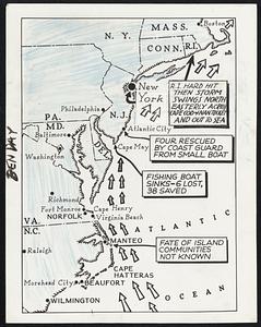
168. The Path Of The Storm-- This map shows the path of the tropical storm that struck the Virginia and Carolina coast with gale force early today and is sweeping up the... Creator: Associated Press Format: Photographs Collection: Boston Herald-Traveler Photo Morgue Date: [ca. September 1936] Institution: Boston Public Library
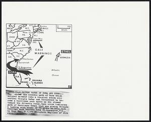
169. The Paths of Dora and Ether--Map shows the erratic path of Dora which whipped herself into a tropical storm over central Georgia today and threatened to become a... Creator: Associated Press Format: Photographs Collection: Boston Herald-Traveler Photo Morgue Date: [ca. September 1964] Institution: Boston Public Library
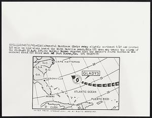
170. Powerful Hurricane Gladys swing slightly northward 9/19 and pointed and pointed 125 mile an hour winds toward the North Carolina coast. This UPI news map traces the... Creator: United Press International Format: Photographs Collection: Boston Herald-Traveler Photo Morgue Date: [ca. September 1964] Institution: Boston Public Library
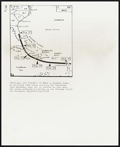
171. Progress of Cleo -- Pathway taken by Hurricane Cleo since entering the Caribbean last Saturday, Aug. 22, is charted in this map. The storm currently is midway up the... Creator: Associated Press Format: Photographs Collection: Boston Herald-Traveler Photo Morgue Date: [ca. August 1964] Institution: Boston Public Library
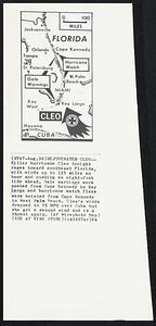
172. Rejuvenated Cleo-- Killer hurricane Cleo tonight rages toward southeast Florida, with winds up to 125 miles an hour and pushing an eight-foot tide ahead. Gale warnings... Creator: Associated Press Format: Photographs Collection: Boston Herald-Traveler Photo Morgue Date: [ca. August 1964] Institution: Boston Public Library
173. Riot Areas- Underlined are places in South Viet Nam where students rioted over weekend, wrecking buildings. Creator: Associated Press Format: Photographs Collection: Boston Herald-Traveler Photo Morgue Date: [ca. August 1964] Institution: Boston Public Library
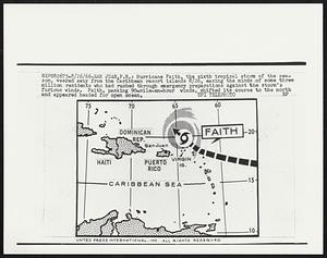
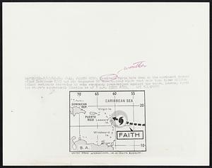
174. San Juan, P.R.: Hurricane Faith, the sixth tropical storm of the season, veered away from the Caribbean resort islands 8/26, easing the minds of some three million... Creator: United Press International Format: Photographs Collection: Boston Herald-Traveler Photo Morgue Date: [ca. August 1966] Institution: Boston Public Library
175. San Juan, Puerto Rico: Hurricane Fatih bore down on the northwest corner of the Caribbean 8/25 and its dangerous 90 mile-an-hour winds sent more than three million... Creator: United Press International Format: Photographs Collection: Boston Herald-Traveler Photo Morgue Date: [ca. August 1966] Institution: Boston Public Library
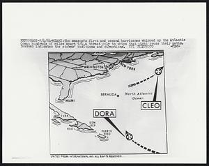
176. The season's first and second hurricanes whipped up the Atlantic Ocean hundreds of miles apart 9/4, a threat only to ships that might cross their paths. Newsmap... Creator: United Press International Format: Photographs Collection: Boston Herald-Traveler Photo Morgue Date: [ca. September 1964] Institution: Boston Public Library
177. Storm Heads For Carolinas--Arrow indicates present course of Hurricane Betsy which is churning its way toward the Carolina coast today. The Miami weather bureau has... Creator: Associated Press Format: Photographs Collection: Boston Herald-Traveler Photo Morgue Date: [ca. September 1965] Institution: Boston Public Library
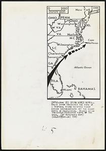
178. Storm Moves North-- Solid arrow indicates the path of a tropical storm reported today moving northeastward off the coast north of Charleston. Broken arrow indicates... Creator: Associated Press Format: Photographs Collection: Boston Herald-Traveler Photo Morgue Date: [ca. June 1945] Institution: Boston Public Library
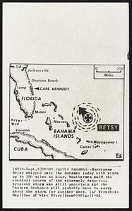
179. Storm Passes Bahamas -- Hurricane Betsy whipped past the Bahamas today with winds up to 150 miles an hour. Weathermen said the eventual course of the extremely... Creator: Associated Press Format: Photographs Collection: Boston Herald-Traveler Photo Morgue Date: [ca. September 1965] Institution: Boston Public Library
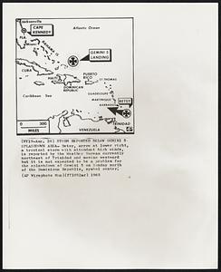
180. Storm Reported Below Gemini 5 Splashdown Area- Betsy, arrow at lower right, a tropical storm with attendant high winds, is reported by the Weather Bureau currently... Creator: Associated Press Format: Photographs Collection: Boston Herald-Traveler Photo Morgue Date: [ca. August 1965] Institution: Boston Public Library