11161. View of Watertown, Mass : 1879 Creator: O.H. Bailey & Co Format: Maps/Atlases Collection: Boston and New England Maps (Collection of Distinction) / Norman B. Leventhal Map & Education Center Collection / Urban Maps (Collection of Distinction) Date: 1879 Institution: Boston Public Library
11162. View of Webster, Mass : 1878 Format: Maps/Atlases Collection: Boston and New England Maps (Collection of Distinction) / Norman B. Leventhal Map & Education Center Collection / Urban Maps (Collection of Distinction) Date: 1878 Institution: Boston Public Library
11163. View of Westerly, R.I : 1877 Creator: Bailey, O. H. (Oakley Hoopes), 1843-1947 Format: Maps/Atlases Collection: Boston and New England Maps (Collection of Distinction) / Norman B. Leventhal Map & Education Center Collection / Urban Maps (Collection of Distinction) Date: 1877 Institution: Boston Public Library
11164. View of Westport, Conn : 1878 Creator: O.H. Bailey & Co Format: Maps/Atlases Collection: Boston and New England Maps (Collection of Distinction) / Norman B. Leventhal Map & Education Center Collection / Urban Maps (Collection of Distinction) Date: 1878 Institution: Boston Public Library
11165. View of Whitman and Brockton, showing location of some of the most desirable building lots, for sale by W.V. Everson, 120 Boylston St. Boston Creator: O.H. Bailey & Co. Format: Maps/Atlases Collection: Boston and New England Maps (Collection of Distinction) / Norman B. Leventhal Map & Education Center Collection / Urban Maps (Collection of Distinction) Date: [ca. 1890–1899] Institution: Boston Public Library
11166. View of Winchendon, Mass : 1878 Creator: Bailey, O. H. (Oakley Hoopes), 1843-1947 Format: Maps/Atlases Collection: Boston and New England Maps (Collection of Distinction) / Norman B. Leventhal Map & Education Center Collection / Urban Maps (Collection of Distinction) Date: 1878 Institution: Boston Public Library
11167. View of Winsted, Conn : 1877 Creator: O.H. Bailey & Co Format: Maps/Atlases Collection: Boston and New England Maps (Collection of Distinction) / Norman B. Leventhal Map & Education Center Collection / Urban Maps (Collection of Distinction) Date: 1877 Institution: Boston Public Library
11168. View showing the works of D.S. Morgan & Co., Brockport, N.Y Creator: H.H. Rowley & Co Format: Maps/Atlases Collection: Norman B. Leventhal Map & Education Center Collection / Urban Maps (Collection of Distinction) Date: [1879–1881] Institution: Boston Public Library
11169. Views of London in 1616 and 1890 Format: Maps/Atlases Collection: Norman B. Leventhal Map & Education Center Collection / Urban Maps (Collection of Distinction) Date: 1890 Institution: Boston Public Library
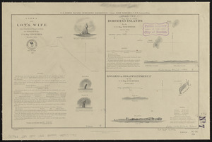
11170. Views of Lot's Wife, taken from Meares' Voyage and from the sketch-book of the U.S. Ship Vincennes, November 1854 ; Borodino Islands by the U.S. Ship Vincennes,... Creator: United States. Hydrographic Office, Knorr, E. R. (Ernest Rudolph), Kern, Edward Meyer, 1823-1863, Waldecker, Louis, and Siebert, Selmar Format: Maps/Atlases Collection: Norman B. Leventhal Map & Education Center Collection Date: 1854 Institution: Boston Public Library
11171. Views of Lot's Wife, taken from Meares' Voyage and from the sketch-book of the U.S. Ship Vincennes, November 1854 ; Borodino Islands by the U.S. Ship Vincennes,... Creator: United States. Hydrographic Office, Knorr, E. R. (Ernest Rudolph), Kern, Edward Meyer, 1823-1863, Waldecker, Louis, and Siebert, Selmar Format: Maps/Atlases Collection: Maritime Charts and Atlases (Collection of Distinction) / Norman B. Leventhal Map & Education Center Collection Date: 1880 Institution: Boston Public Library
11172. Views of the area around Dudley Station in Roxbury Format: Maps/Atlases Collection: Boston Redevelopment Authority Collection / Boston and New England Maps (Collection of Distinction) / Norman B. Leventhal Map & Education Center Collection / Urban Maps (Collection of Distinction) Date: [1980?–1989?] Institution: Boston Public Library
11173. Views of the Boston Harbor Islands Creator: U.S. Coast and Geodetic Survey; U.S. Coast and Geodetic Survey Format: Prints Collection: Boston and New England Maps (Collection of Distinction) / Norman B. Leventhal Map & Education Center Collection Date: 1855 Institution: Boston Public Library
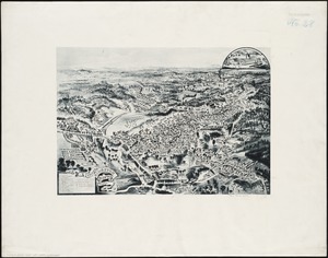
11174. [Views of the Boston Harbor Islands] Creator: U.S. Coast and Geodetic Survey Format: Maps/Atlases Collection: Boston and New England Maps (Collection of Distinction) / Norman B. Leventhal Map & Education Center Collection Date: [1855] Institution: Boston Public Library
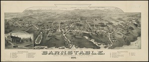
11175. Village of Barnstable, seat of Barnstable County, Mass : 1884 Creator: Poole, A. F. Format: Maps/Atlases Collection: Boston and New England Maps (Collection of Distinction) / Norman B. Leventhal Map & Education Center Collection / Urban Maps (Collection of Distinction) Date: 1884 Institution: Boston Public Library
11176. Village of Kingston, Plymouth County, Mass : 1885 Format: Maps/Atlases Collection: Boston and New England Maps (Collection of Distinction) / Norman B. Leventhal Map & Education Center Collection / Urban Maps (Collection of Distinction) Date: 1885 Institution: Boston Public Library
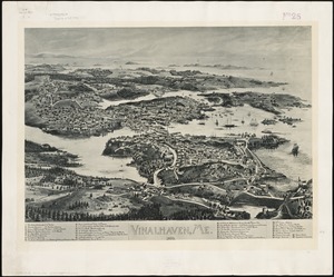
11177. Vinalhaven, Me : 1893 Creator: Norris, George E. Format: Maps/Atlases Collection: Boston and New England Maps (Collection of Distinction) / Norman B. Leventhal Map & Education Center Collection / Urban Maps (Collection of Distinction) Date: [1893] Institution: Boston Public Library
11178. Vineyard Haven, Dukes County, Martha's Vineyard, Massachusetts : the popular seaside summer resort Creator: Walker, G. H. (George H.) Format: Maps/Atlases Collection: Boston and New England Maps (Collection of Distinction) / Norman B. Leventhal Map & Education Center Collection / Urban Maps (Collection of Distinction) Date: [1893?] Institution: Boston Public Library
11179. Vineyard Sound and Buzzards Bay, Massachusetts Creator: U.S. Coast and Geodetic Survey Format: Maps/Atlases Collection: Boston and New England Maps (Collection of Distinction) / Maritime Charts and Atlases (Collection of Distinction) / Norman B. Leventhal Map & Education Center Collection Date: 1895 Institution: Boston Public Library
11180. Virginia Creator: Smith, John, 1580-1631 Format: Maps/Atlases Collection: Norman B. Leventhal Map & Education Center Collection Date: [1866?] Institution: Boston Public Library


![[Views of the Boston Harbor Islands]](https://bpldcassets.blob.core.windows.net/derivatives/images/commonwealth:1v53jx85b/image_thumbnail_300.jpg)