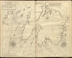
4021. A chart shewing part of the sea coast of Newfoundland from ye Bay of Bulls to little Plecentia Creator: Gaudy, John. Format: Maps/Atlases Collection: Maritime Charts and Atlases (Collection of Distinction) / Norman B. Leventhal Map & Education Center Collection Date: [1737] Institution: Boston Public Library
4022. Chart shewing the tracks across the North Atlantic Ocean of Don Christopher Columbus Creator: Touquet, J.-B. (Jean-Baptiste-Paul) Format: Maps/Atlases Collection: Norman B. Leventhal Map & Education Center Collection Date: 1828 Institution: Boston Public Library
4023. Charte der vereinigten Königreiche Grosbritanien und Ireland : nach den neuesten Berichtigungen und Astronomischen Ortsbesti[m]mungen entworfen auf den Sternwarte... Creator: Weidner, I. G. A. Format: Maps/Atlases Collection: Norman B. Leventhal Map & Education Center Collection Date: 1804 Institution: Boston Public Library
4024. Charte des Königreichs Daenemark : nach Murdochischer Projection und nach den trigonometrischen Charten der König Format: Maps/Atlases Collection: Norman B. Leventhal Map & Education Center Collection Date: 1816 Institution: Boston Public Library
4025. Charte über die XIII Vereinigte Staaten von Nord-America Creator: Güssefeld, F. L. (Franz Ludwig), 1744-1807 Format: Maps/Atlases Collection: American Revolutionary War-Era Maps (Collection of Distinction) / Norman B. Leventhal Map & Education Center Collection Date: 1784 Institution: Boston Public Library
4026. Charte von den Königreichen Preussen und Polen dem Grosherzogthum Posen nebst dem Gebiete der freien Stadt Krakau : nach dem am 3ten May 1815 zu Wien zwischen... Creator: Sotzmann, -F.; Geographisches Institut (Weimar, Thuringia, Germany) Format: Maps/Atlases Collection: Norman B. Leventhal Map & Education Center Collection Date: 1815 Institution: Boston Public Library
4027. Charte von Italien : Nach seiner neuesten Eintheilung und den vorzüglichsten Hülfsmitteln Creator: Gaspari, Adam Christian, 1752-1830 Format: Maps/Atlases Collection: Norman B. Leventhal Map & Education Center Collection Date: 1809 Institution: Boston Public Library
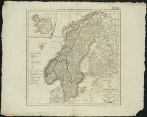
4028. Charte von Schweden und Norwegen Creator: Reinecke, J. C. M. (Johann Christoph Matthias), 1770-1818 Format: Maps/Atlases Collection: Norman B. Leventhal Map & Education Center Collection Date: 1809 Institution: Boston Public Library
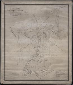
4029. Chatham Lights to south west part of Handkerchief Creator: Eldridge, George, -1900; Tappan & Bradford Format: Maps/Atlases Collection: Boston and New England Maps (Collection of Distinction) / Maritime Charts and Atlases (Collection of Distinction) / Norman B. Leventhal Map & Education Center Collection Date: 1851 Institution: Boston Public Library
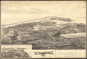
4030. Chatham, Mass Creator: Norris, George E. Format: Maps/Atlases; Prints; Manuscripts Collection: Boston and New England Maps (Collection of Distinction) / Norman B. Leventhal Map & Education Center Collection / Urban Maps (Collection of Distinction) Date: 1894 Institution: Boston Public Library
4031. Chester Format: Maps/Atlases; Manuscripts Collection: Boston and New England Maps (Collection of Distinction) / Norman B. Leventhal Map & Education Center Collection Date: 1880 Institution: Boston Public Library
4032. Chester, Mass : 1885 Creator: Burleigh, L. R., 1853-1923 Format: Maps/Atlases Collection: Boston and New England Maps (Collection of Distinction) / Norman B. Leventhal Map & Education Center Collection / Urban Maps (Collection of Distinction) Date: [1885] Institution: Boston Public Library
4033. The Chevron trail through the scenic west Creator: Standard Oil Company of California Format: Maps/Atlases Collection: Norman B. Leventhal Map & Education Center Collection Date: [ca. 1950–1959] Institution: Boston Public Library
4034. [Chiapas] Format: Maps/Atlases Collection: Norman B. Leventhal Map & Education Center Collection Date: [1900–1914] Institution: Boston Public Library
4035. Chicago Creator: Van Vechten, J. Format: Maps/Atlases Collection: Norman B. Leventhal Map & Education Center Collection / Urban Maps (Collection of Distinction) Date: 1863 Institution: Boston Public Library
4036. Chicago Creator: Gemmell, John. Format: Maps/Atlases Collection: Norman B. Leventhal Map & Education Center Collection / Urban Maps (Collection of Distinction) Date: 1858 Institution: Boston Public Library
4037. Chicago, Burlington & Quincy R.R. and intersecting lines Creator: Rand McNally and Company Format: Maps/Atlases Collection: Norman B. Leventhal Map & Education Center Collection Date: 1883 Institution: Boston Public Library
4038. Chicago motor coach pictorial map of Chicago Creator: Clason Map Co. Format: Maps/Atlases Collection: Norman B. Leventhal Map & Education Center Collection Date: [1926?] Institution: Boston Public Library
4039. Chicago Terminal Transfer Railroad Co. map showing property of railroads in the business center of Chicago Creator: Chicago Terminal Transfer Railroad Company Format: Maps/Atlases Collection: Norman B. Leventhal Map & Education Center Collection / Urban Maps (Collection of Distinction) Date: 1898 Institution: Boston Public Library
4040. Chickamauga and Chattanooga National Military Park and approaches Creator: Chickamauga and Chattanooga National Military Park Commission Format: Maps/Atlases Collection: Norman B. Leventhal Map & Education Center Collection Date: [1900] Institution: Boston Public Library


![[Chiapas]](https://bpldcassets.blob.core.windows.net/derivatives/images/commonwealth:4m90fj278/image_thumbnail_300.jpg)


