4501. Das Deutsche Reich : in 4 Blättern Creator: Vogel, C. (Carl), 1828-1897, Scherrer, Carl, and Justus Perthes (Firm : Gotha, Germany) Format: Maps/Atlases Collection: Norman B. Leventhal Map & Education Center Collection Date: 1912 Institution: Boston Public Library
4502. Deutschland Creator: Weiland, C. F. (Carl Ferdinand), 1782-1847; Geographisches Institut (Weimar, Thuringia, Germany) Format: Maps/Atlases Collection: Norman B. Leventhal Map & Education Center Collection Date: 1831 Institution: Boston Public Library
4503. Deutschland in seiner neugestaltung Creator: Kiepert, Heinrich, 1818-1899, Reimer, Dietrich, 1818-1899, and Sulzer, J. Format: Maps/Atlases Collection: Norman B. Leventhal Map & Education Center Collection Date: 1870 Institution: Boston Public Library
4504. Deutschland, königr. der Niederlande, kgr. Belgien und die Schweiz, nebst theilen der angränzenden länder nach Adolf Stieler's grosser karte in 25 bl. Creator: Diez, Franz Maximillian, Stülpnagel, F. von, Bär, J. C., Stieler, Adolf, 1775-1836, and Justus Perthes (Firm : Gotha, Germany) Format: Maps/Atlases Collection: Norman B. Leventhal Map & Education Center Collection Date: 1845 Institution: Boston Public Library
4505. Deutschland nebst den königreichen Holland, Belgien und der republik Schweiz Creator: Ravenstein, August Format: Maps/Atlases Collection: Norman B. Leventhal Map & Education Center Collection Date: 1865 Institution: Boston Public Library
4506. Deutschland und der gröste theil der umliegenden staaten oder Mittel-Europa in 35 blättern : nach astronomischen ortsbestimmungen und den besten special-karten, mit... Creator: Gotthold, H. H., Kliewer, Heinrich (Engraver), Schmidt, Paulus (Engraver), and Jaettnig, Karl, 1796-1835 Format: Maps/Atlases Collection: Norman B. Leventhal Map & Education Center Collection Date: 1820 Institution: Boston Public Library
4507. Deutschland und der gröste theil der umliegenden staaten, oder Mittel-Europa in 35 blättern : nach astronomischen ortsbestimmungen und den besten special-karten, mit... Creator: Gotthold, H. H., Kliewer, Heinrich (Engraver), Jaettnig, Karl, 1796-1835, and Schmidt, Paulus (Engraver) Format: Maps/Atlases Collection: Norman B. Leventhal Map & Education Center Collection Date: [1808–1813] Institution: Boston Public Library
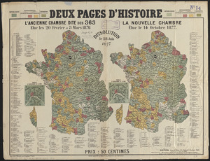
4508. Deux pages d'histoire : l'ancienne Chambre dite des 363, elue les 20 Février et 5 Mars 1876, dissolution le 23 Juin 1877, la nouvelle Chambre, élue le 14 Octobre 1877 Creator: Glücq; Hermet, F. Format: Maps/Atlases Collection: Norman B. Leventhal Map & Education Center Collection Date: [1877?] Institution: Boston Public Library
4509. Devoniae descriptio : the description of Devonshire Creator: Jansson, Jan, 1588-1664 Format: Maps/Atlases Collection: Norman B. Leventhal Map & Education Center Collection Date: [1646–1680] Institution: Boston Public Library
4510. Diagram of rail roads diverging from Boston : showing the depots and distances Creator: Lewis, Alonzo, 1794-1861 Format: Maps/Atlases Collection: Boston and New England Maps (Collection of Distinction) / Norman B. Leventhal Map & Education Center Collection Date: [1846?] Institution: Boston Public Library
4511. Diagram of the Battle of Ball's Bluff Format: Maps/Atlases Collection: Norman B. Leventhal Map & Education Center Collection Date: 1861 Institution: Boston Public Library
4512. A diagram of the triangulation for the survey of the coast of the United States, made in 1817 and 1833, and the secondary triangles made in 1833 & 1834 in Connecticut... Creator: United States Coast Survey Format: Maps/Atlases Collection: Norman B. Leventhal Map & Education Center Collection Date: [1830?–1839?] Institution: Boston Public Library
4513. Diagram of the United States of America, Mexico, the West India Islands and Isthmus of Darien : showing proposed routes of the Pacific Rail Road Creator: Steiger, W. T. Format: Maps/Atlases Collection: Norman B. Leventhal Map & Education Center Collection Date: 1854 Institution: Boston Public Library
4514. Diagram showing the Changuinola Railroad lines Creator: United Fruit Company. Engineering Department Format: Maps/Atlases Collection: Norman B. Leventhal Map & Education Center Collection Date: 1923 Institution: Boston Public Library
4515. Diagram to illustrate contrast between British and Chinese Empires Creator: Curtis, Lionel, 1872-1955 Format: Maps/Atlases Collection: Norman B. Leventhal Map & Education Center Collection Date: 1917 Institution: Boston Public Library
4516. A diagrammatic road map of Central Europe : for the use of automobilists and cyclists Creator: McMurtry, Wood Format: Maps/Atlases Collection: Norman B. Leventhal Map & Education Center Collection Date: [1910–1918] Institution: Boston Public Library
4517. Dinsmore's complete map of the railroads & canals in the United States & Canada Creator: Fisher, Richard Swainson. Format: Maps/Atlases Collection: Norman B. Leventhal Map & Education Center Collection Date: 1856 Institution: Boston Public Library
4518. Dinsmore's complete map of the railroads & canals in the United States & Canada Creator: Fisher, Richard Swainson. Format: Maps/Atlases Collection: Norman B. Leventhal Map & Education Center Collection Date: 1856 Institution: Boston Public Library
4519. Dinsmore's new railroad map of the United States and the Canadas, showing all the railroads completed and in progress, carefully compiled from official sources, for... Format: Maps/Atlases Collection: Norman B. Leventhal Map & Education Center Collection Date: [1860] Institution: Boston Public Library
4520. Diocèse de Castres, dédié à Messire Augustin de Maupeou, Conseiller du Roy en ses Conseils Evêque de Castres Creator: Jaillot, Alexis Hubert, 1632?-1712 Format: Maps/Atlases Collection: Norman B. Leventhal Map & Education Center Collection Date: 1700 Institution: Boston Public Library