4541. District within fire limit of Tokyo - 1928 Format: Maps/Atlases Collection: Norman B. Leventhal Map & Education Center Collection Date: [1928] Institution: Boston Public Library
4542. Disturnell's new map of the United States and Canada showing all the canals, rail roads, telegraph lines and principal stage routes Creator: Burr, Henry A. Format: Maps/Atlases Collection: Norman B. Leventhal Map & Education Center Collection Date: 1854 Institution: Boston Public Library
4543. Diversi globi terr-aquei statione variante et visu intercedente, per coluros tropicorum, per ambos polos et particul : sphaerae zenith in planum delineati... Creator: Seutter, Matthaeus, 1678-1756 Format: Maps/Atlases Collection: Norman B. Leventhal Map & Education Center Collection Date: [1730] Institution: Boston Public Library
4544. Dobroudja Campaigne, Oct. 1916 : Volhynie Campaigne, Oct. 1916 ; Izonzo Campaigne, Oct. 1916 Format: Maps/Atlases Collection: Norman B. Leventhal Map & Education Center Collection Date: [1916?] Institution: Boston Public Library
4545. Dodge County, Wis. Format: Maps/Atlases; Manuscripts Collection: Norman B. Leventhal Map & Education Center Collection Date: [ca. 1880–1889] Institution: Boston Public Library
4546. Dodgeville, Massachusetts Creator: O.H. Bailey & Co Format: Maps/Atlases Collection: Boston and New England Maps (Collection of Distinction) / Norman B. Leventhal Map & Education Center Collection / Urban Maps (Collection of Distinction) Date: 1891 Institution: Boston Public Library
4547. Domina Anglorum in America Septentrionali specialibus mappis Londini primum a Mollio edita, nunc recusa ab Homannianis Hered = Die Gros-Britannische colonie-laender,... Creator: Homann Erben (Firm) Format: Maps/Atlases Collection: American Revolutionary War-Era Maps (Collection of Distinction) / Norman B. Leventhal Map & Education Center Collection Date: [1759?] Institution: Boston Public Library
4548. Dominia anglorum in præcipuis insulis Americæ ut sunt insula : S. Christophori, Antegoa, Iamaica, Barbados : nec non insulae Bermudes vel Sommers dictae Creator: Homann Erben (Firm) Format: Maps/Atlases Collection: American Revolutionary War-Era Maps (Collection of Distinction) / Norman B. Leventhal Map & Education Center Collection Date: [1759] Institution: Boston Public Library
4549. Dominica Creator: Jefferys, Thomas, -1771; Sayer, Robert, 1725-1794 Format: Maps/Atlases Collection: Norman B. Leventhal Map & Education Center Collection Date: [1768] Institution: Boston Public Library
4550. Dominica from an actual survey compleated in the year 1773 Creator: Jefferys, Thomas, d. 1771 Format: Maps/Atlases Collection: American Revolutionary War-Era Maps (Collection of Distinction) / Norman B. Leventhal Map & Education Center Collection Date: 1775 Institution: Boston Public Library
4551. Dominican Republic road map 1:250,000 Creator: United States. Army Map Service Format: Maps/Atlases Collection: Norman B. Leventhal Map & Education Center Collection Date: [1961] Institution: Boston Public Library
4552. Dominio Fiorentino Creator: Jansson, Jan, 1588-1664 Format: Maps/Atlases Collection: Norman B. Leventhal Map & Education Center Collection Date: [ca. 1653–1666] Institution: Boston Public Library
4553. Dominion of Canada Creator: W. & A.K. Johnston Limited Format: Maps/Atlases Collection: Norman B. Leventhal Map & Education Center Collection Date: [1895–1898] Institution: Boston Public Library
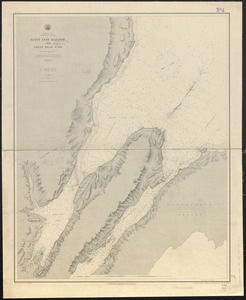
4554. Dominion of Canada, Cape Breton Island, Saint Anne Harbor and Great Bras d'Or : from British surveys in 1848-57 Creator: United States. Hydrographic Office, Franke, M. (Max), Klakring, A. (Alfred), Ourdan, V. L. (Vincent L.), Sefton, W. P. (William P.), and Wimpffen, L. F. von (Lebreclit Felix von) Format: Maps/Atlases Collection: Maritime Charts and Atlases (Collection of Distinction) / Norman B. Leventhal Map & Education Center Collection Date: 1889 Institution: Boston Public Library
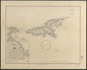
4555. Dominion of Canada, Cape Breton Island, Scatari Island and Menadou Passage : from a British survey in 1850 Creator: United States. Hydrographic Office, Erni, A. (Adolphe), Gaskins, R. H. (Richard H.), Klakring, A. (Alfred), and Latimer, J. S. (Joseph S.) Format: Maps/Atlases Collection: Maritime Charts and Atlases (Collection of Distinction) / Norman B. Leventhal Map & Education Center Collection Date: 1888 Institution: Boston Public Library
4556. Dominion of Canada, Cape Breton Island, Sydney Harbor : from a British survey in 1849 Creator: United States. Hydrographic Office, Dougal, W. M. (William M.), Ourdan, V. L. (Vincent L.), and Wimpffen, L. F. von (Lebreclit Felix von) Format: Maps/Atlases Collection: Maritime Charts and Atlases (Collection of Distinction) / Norman B. Leventhal Map & Education Center Collection Date: 1888 Institution: Boston Public Library
4557. The Dominion of Canada from the latest surveys and data Creator: Cram, George Franklin, 1841-1928 Format: Maps/Atlases Collection: Norman B. Leventhal Map & Education Center Collection Date: [1913] Institution: Boston Public Library
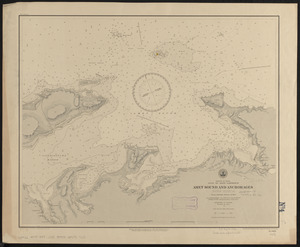
4558. Dominion of Canada, Gulf of Saint Lawrence, Amet Sound and anchorages (Nova Scotia) : from a British survey in 1841 Creator: United States. Hydrographic Office, Franke, M. (Max), Klakring, A. (Alfred), Noetzel, G. (Gregor), and Ourdan, V. L. (Vincent L.) Format: Maps/Atlases Collection: Maritime Charts and Atlases (Collection of Distinction) / Norman B. Leventhal Map & Education Center Collection Date: 1888 Institution: Boston Public Library
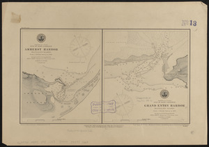
4559. Dominion of Canada, Gulf of Saint Lawrence, Amherst Harbor (Magdalen Islands) : from a British survey in 1833 ; Dominion of Canada, Gulf of Saint Lawrence, Grand Entry... Creator: United States. Hydrographic Office, Gaskins, R. H. (Richard H.), Gray, R. E. (Ross E.), Klakring, A. (Alfred), and Latimer, J. S. (Joseph S.) Format: Maps/Atlases Collection: Maritime Charts and Atlases (Collection of Distinction) / Norman B. Leventhal Map & Education Center Collection Date: 1888 Institution: Boston Public Library
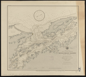
4560. Dominion of Canada, Gulf of Saint Lawrence, Merigomish Harbor (Nova Scotia) : from a British survey in 1842 Creator: United States. Hydrographic Office, Enthoffer, E. J. (Edward J.), Franke, M. (Max), Latimer, J. S. (Joseph S.), and Ourdan, V. L. (Vincent L.) Format: Maps/Atlases Collection: Maritime Charts and Atlases (Collection of Distinction) / Norman B. Leventhal Map & Education Center Collection Date: 1888 Institution: Boston Public Library