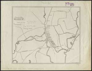
1. Maps of Providence, R.I., 1650, 1765, 1770 Creator: Chace, Henry R. (Henry Richmond), 1838-1916 Format: Maps/Atlases Collection: Norman B. Leventhal Map & Education Center Collection Date: [1914] Institution: Boston Public Library
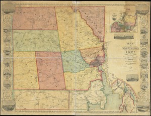
2. Map of Providence County, Rhode Island, with some of the adjacent towns Creator: Walling, Henry Francis, 1825-1888 Format: Maps/Atlases Collection: Boston and New England Maps (Collection of Distinction) / Norman B. Leventhal Map & Education Center Collection Date: 1851 Institution: Boston Public Library
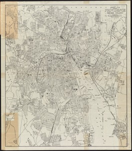
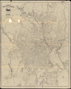
3. Map of Providence, Rhode Island Creator: Walker Lith. & Pub. Co Format: Maps/Atlases Collection: Norman B. Leventhal Map & Education Center Collection Date: [1915?] Institution: Boston Public Library
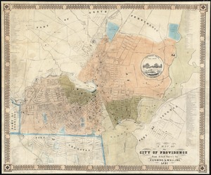
4. A map of the city of Providence : from actual survey Creator: Cushing, S. B. (Samuel B.) Format: Maps/Atlases Collection: Boston and New England Maps (Collection of Distinction) / Norman B. Leventhal Map & Education Center Collection / Urban Maps (Collection of Distinction) Date: 1851 Institution: Boston Public Library
5. Map of the city of Providence, Rhode Island : compiled from the most authentic sources Creator: Sampson, Murdock & Co Format: Maps/Atlases Collection: Boston and New England Maps (Collection of Distinction) / Norman B. Leventhal Map & Education Center Collection / Urban Maps (Collection of Distinction) Date: 1894 Institution: Boston Public Library
6. Map of the city of Providence, Rhode Island : compiled from the most authentic sources Creator: Sampson, Murdock & Co Format: Maps/Atlases Collection: Boston and New England Maps (Collection of Distinction) / Norman B. Leventhal Map & Education Center Collection / Urban Maps (Collection of Distinction) Date: 1899 Institution: Boston Public Library
7. Map of the city of Providence, Rhode Island Creator: Sampson, Murdock & Co. Format: Maps/Atlases Collection: Boston and New England Maps (Collection of Distinction) / Norman B. Leventhal Map & Education Center Collection Date: 1935 Institution: Boston Public Library
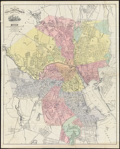
8. Map of the city of Providence, Rhode Island Creator: Walling, Henry Francis, 1825-1888 Format: Maps/Atlases Collection: Boston and New England Maps (Collection of Distinction) / Norman B. Leventhal Map & Education Center Collection / Urban Maps (Collection of Distinction) Date: 1875 Institution: Boston Public Library
9. Plan of the city of Providence Creator: Schubarth, N. B Format: Maps/Atlases Collection: Boston and New England Maps (Collection of Distinction) / Norman B. Leventhal Map & Education Center Collection / Urban Maps (Collection of Distinction) Date: 1844 Institution: Boston Public Library
10. The 100th anniversary map of Abraham Lincoln's visit to Massachusetts, September 11-23, 1848 Creator: Lufkin, Richard F. (Richard Friend) Format: Maps/Atlases Collection: Norman B. Leventhal Map & Education Center Collection Date: 1948 Institution: Boston Public Library
11. 1630 shoreline Creator: Metropolitan Planning Organization (Mass.). Central Transportation Planning Staff Format: Maps/Atlases Collection: Norman B. Leventhal Map & Education Center Collection Date: 2011 Institution: Boston Public Library
12. 1879. Progress map of the U.S. Geographical Surveys west of the 100th Meridian : prepared under the direction of 1st Lieut. George M. Wheeler, Corps of Engineers U. S.... Creator: Geographical Surveys West of the 100th Meridian (U.S.) Format: Maps/Atlases Collection: Norman B. Leventhal Map & Education Center Collection Date: [1879?] Institution: Boston Public Library
13. 1903 Map of Salem and surrounding places Creator: Henry M. Meek Pub. Co. (Salem, Mass.) Format: Maps/Atlases Collection: Norman B. Leventhal Map & Education Center Collection Date: 1903 Institution: Boston Public Library
14. 19th annual convention of the National Association of Real Estate Boards : at Tulsa, June 7 to June 11 in 1926 Creator: National Association of Real Estate Boards, R.R. Donnelley and Sons Company, and Sahula-Dycke, Ignatz, 1900-1982 Format: Maps/Atlases Collection: Norman B. Leventhal Map & Education Center Collection Date: 1926 Institution: Boston Public Library
15. 2005 significant U.S. hurricane strikes Creator: National Climatic Data Center (U.S.), National Climatic Data Center (U.S.), and United States. National Oceanic and Atmospheric Administration Format: Posters Collection: Norman B. Leventhal Map & Education Center Collection Date: [2005] Institution: Boston Public Library
16. 227 Harzgerode Creator: Prussia (Kingdom). Armee. Grosser Generalstab, Meyer, A., and Ruzek Format: Maps/Atlases Collection: Norman B. Leventhal Map & Education Center Collection Date: 1868 Institution: Boston Public Library
17. 305 Glatz Creator: Prussia (Kingdom). Armee. Grosser Generalstab; Petters, H. Format: Maps/Atlases Collection: Norman B. Leventhal Map & Education Center Collection Date: 1870 Institution: Boston Public Library
18. 38,000,000 escaped -- 10,000,000 died Creator: Russian War Relief, Inc.; Means, E. Format: Maps/Atlases Collection: Norman B. Leventhal Map & Education Center Collection Date: [ca. 1940–1949] Institution: Boston Public Library
19. 4 Kinten Creator: Prussia (Kingdom). Armee. Grosser Generalstab; Siebert, Selmar Format: Maps/Atlases Collection: Norman B. Leventhal Map & Education Center Collection Date: 1860 Institution: Boston Public Library
20. 660 Wakulah St., Roxbury Creator: Boston Redevelopment Authority Format: Maps/Atlases Collection: Boston Redevelopment Authority Collection / Boston and New England Maps (Collection of Distinction) / Norman B. Leventhal Map & Education Center Collection / Urban Maps (Collection of Distinction) Date: May 1989 Institution: Boston Public Library