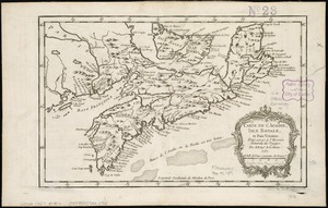
4781. Carte de l'Acadie, Isle Royale, et Païs Voisins : pour servir à l'Histoire Générale des voyages Creator: Bellin, Jacques Nicolas, 1703-1772 Format: Maps/Atlases Collection: American Revolutionary War-Era Maps (Collection of Distinction) / Norman B. Leventhal Map & Education Center Collection Date: 1757 Institution: Boston Public Library
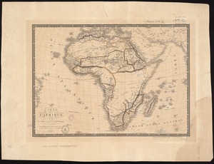
4782. Carte de l'Afrique Creator: Brué, Adrien Hubert, 1786-1832 Format: Maps/Atlases Collection: Norman B. Leventhal Map & Education Center Collection Date: 1822 Institution: Boston Public Library
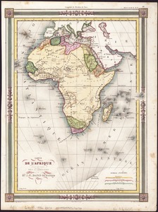
4783. Carte de l'Afrique Creator: Barbié du Bocage, Jean Guillaume, 1795-1848 Format: Maps/Atlases Collection: Norman B. Leventhal Map & Education Center Collection Date: [1846] Institution: Boston Public Library
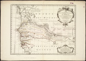
4784. Carte de l'Afrique Françoise ou du Sénégal : dressée sur un grand nombre de cartes manuscrites et d'itineraires rectifiés par diverses observations Creator: L'Isle, Guillaume de, 1675-1726 Format: Maps/Atlases Collection: Norman B. Leventhal Map & Education Center Collection Date: [1745] Institution: Boston Public Library
4785. Carte de l'Amérique Septentrionale Creator: Barbié du Bocage, J. G. Format: Maps/Atlases Collection: Norman B. Leventhal Map & Education Center Collection Date: 1846 Institution: Boston Public Library
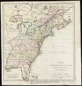
4786. Carte de l'Amérique septentrionale, depuis la baye d'Hudson jusqu'au Mississipi : pour servir aux essais historiques et politiques sur la révolution de cette partie... Format: Maps/Atlases Collection: American Revolutionary War-Era Maps (Collection of Distinction) / Norman B. Leventhal Map & Education Center Collection Date: [1782] Institution: Boston Public Library
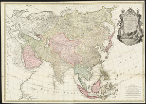
4787. Carte de l'Asie divisée en ses principaux etats Creator: Bonne, Rigobert, 1727-1794, Bonne, Rigobert, 1727-1794, and Lattré, Jean Format: Maps/Atlases Collection: Norman B. Leventhal Map & Education Center Collection Date: 1779 Institution: Boston Public Library
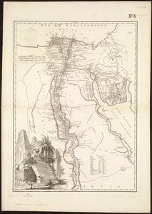
4788. Carte de l'Egypte ancienne et moderne : dressée sur celle du R. P. Sicard, et autres assujetties aux observations astronomique Creator: Robert de Vaugondy, Gilles, 1688-1766 Format: Maps/Atlases Collection: Norman B. Leventhal Map & Education Center Collection Date: 1753 Institution: Boston Public Library
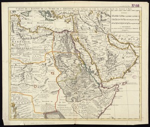
4789. Carte de l'Egypte, de la Nubie, de l'Abissinie &c Creator: L'Isle, Guillaume de, 1675-1726 Format: Maps/Atlases Collection: Norman B. Leventhal Map & Education Center Collection Date: [1733] Institution: Boston Public Library
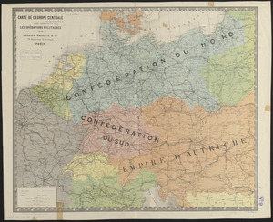
4790. Carte de l'Europe Centrale pour suivre les opérations militaires Creator: Hachette (Firm) Format: Maps/Atlases Collection: Norman B. Leventhal Map & Education Center Collection Date: [1870] Institution: Boston Public Library
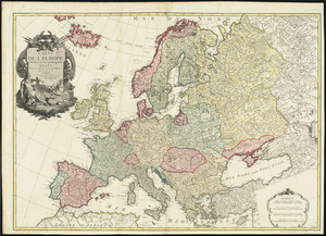
4791. Carte de l'Europe divisée en ses principaux états Creator: Bonne, Rigobert, 1727-1794, Bonne, Rigobert, 1727-1794, and Lattré, Jean Format: Maps/Atlases Collection: Norman B. Leventhal Map & Education Center Collection Date: 1779 Institution: Boston Public Library
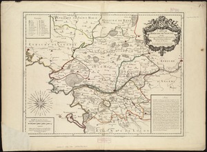
4792. Carte de l'evesché de Nantes Creator: Lambilly, Guillaume de, 1649-1699 Format: Maps/Atlases Collection: Norman B. Leventhal Map & Education Center Collection Date: 1706 Institution: Boston Public Library
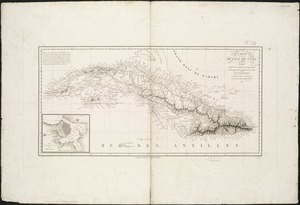
4793. Carte de l'ile de Cuba Creator: Lapie, (Pierre), M, 1779-1850 Format: Maps/Atlases Collection: Norman B. Leventhal Map & Education Center Collection Date: 1820 Institution: Boston Public Library
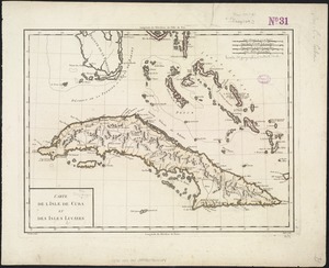
4794. Carte de l'Isle de Cuba et des Isles Lucayes Creator: Mentelle, E. (Edme), 1730-1815 Format: Maps/Atlases Collection: American Revolutionary War-Era Maps (Collection of Distinction) / Norman B. Leventhal Map & Education Center Collection Date: [1789?] Institution: Boston Public Library
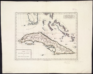
4795. Carte de l'Isle de Cuba et des Isles Lucayes Creator: Mentelle, E. (Edme), 1730-1815 Format: Maps/Atlases Collection: Norman B. Leventhal Map & Education Center Collection Date: [1801] Institution: Boston Public Library
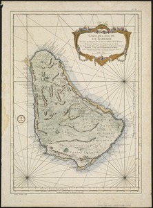
4796. Carte de l'Isle de La Barbade : avec une description geographique de cette isle Creator: Bellin, Jacques Nicolas, 1703-1772 Format: Maps/Atlases Collection: American Revolutionary War-Era Maps (Collection of Distinction) / Norman B. Leventhal Map & Education Center Collection Date: [1758] Institution: Boston Public Library
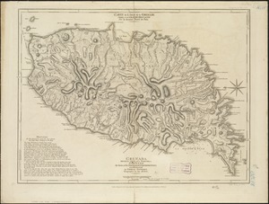
4797. Carte de l'Isle de la Grenade cédée a la Grand Bretagne par le dernier traité de paix = Grenada divided into its parishes : surveyed by order of his excellency... Creator: Jefferys, Thomas, d. 1771 Format: Maps/Atlases Collection: American Revolutionary War-Era Maps (Collection of Distinction) / Norman B. Leventhal Map & Education Center Collection Date: 1775 Institution: Boston Public Library
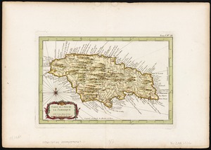
4798. Carte de l'Isle de la Jamaique Creator: Bellin, Jacques Nicolas, 1703-1772 Format: Maps/Atlases Collection: American Revolutionary War-Era Maps (Collection of Distinction) / Maritime Charts and Atlases (Collection of Distinction) / Norman B. Leventhal Map & Education Center Collection Date: [1764] Institution: Boston Public Library
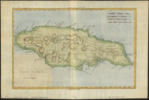
4799. Carte de l'isle de la Jamaïque Creator: Bonne, Rigobert, 1727-1794 Format: Maps/Atlases Collection: American Revolutionary War-Era Maps (Collection of Distinction) / Norman B. Leventhal Map & Education Center Collection Date: [1780] Institution: Boston Public Library
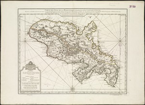
4800. Carte de l'isle de la Martinique colonie Françoise de l'une des isles Antilles de l'Amérique Creator: L'Isle, Guillaume de, 1675-1726 Format: Maps/Atlases Collection: Norman B. Leventhal Map & Education Center Collection Date: 1745 Institution: Boston Public Library