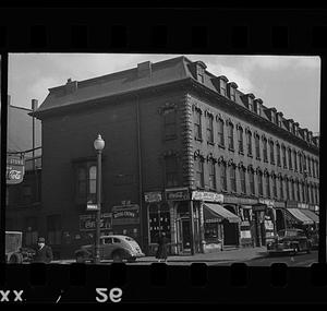
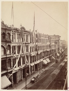
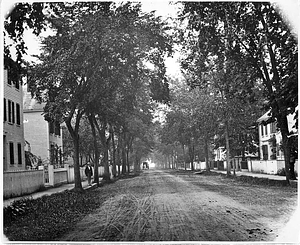
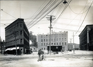
Skip to search
Skip to main content
Skip to first result
Digital Commonwealth
Folders
Sign Up / Log In
Search for
Search
Search
Search
Basic
Advanced
Explore
Map
Collections
Institutions
Formats
For Educators
Primary Source Sets
Lesson Plans
Using Primary Sources
Searching Digital Commonwealth
For Institutions
Join Digital Commonwealth
Conferences, Trainings, & Events
How to Contribute Collections
Digitization Services
Board & Committees
Frequently Asked Questions
About
About Digital Commonwealth
News & Announcements
Copyright & Terms of Use
Harmful Content Statement
Partners
API
Contact Us
Search
Search Constraints
Start Over
Save Search
Your search:
More Like
commonwealth:pc28c1634
✖
Remove constraint More Like: commonwealth:pc28c1634
« Prev.
|
17,801
-
17,820
of
18,214
|
Next »
Sort
by relevance
relevance
title
date (asc)
date (desc)
recently added
Number of results to display per page
20
per page
per page
10
per page
20
per page
50
per page
100
per page
View results as:
List
list view
Maps
map view
Gallery
grid view
Search Results
17801.
Washington Street, Boston, Massachusetts, between Pelham Street and West Dedham Street
17802.
Washington Street, Boston, Massachusetts, between Wilkes Street and Waltham Street
17803.
Washington Street, east side between Sagamore and Broad
17804.
Washington Street, east side, from Amity to Broad
17805.
Washington Street, east side looking south from opposite the head of Milk St.
17806.
Washington Street from opposite Suffolk to Broad
17807.
Washington Street in spring, Marblehead
17808.
Washington Street in Summer, Marblehead
17809.
Washington Street, Junction of Oxford and Central Avenue, from Willow and Central Avenue
17810.
Washington Street looking east
17811.
Washington Street looking east
17812.
Washington Street looking toward Spring Lane, School Street, Milk Street, and Old South Meeting House
17813.
Washington Street looking west
17814.
[Washington Street near number 739]
17815.
Washington Street, north, showing junction with Broad and Spring Streets
17816.
Washington Street showing Congregational Church, North Falmouth, Mass.
17817.
Washington Street showing Congregational Church, North Falmouth, Mass.
17818.
Washington Street, west side, from B & M Power House to Breed Coal Company
17819.
Washington Street, west side, from Breed Coal Company to point opposite Amity Street
17820.
Washington Street, west side, from Lynn Yacht Club to B & M Power House
« Previous
Next »
1
2
…
887
888
889
890
891
892
893
894
895
…
910
911
Limit your search
Subject
Streets
10,078
Cities & towns
8,270
Buildings
1,539
Houses
1,322
Trees
856
Rivers
815
Automobiles
801
Skyscrapers
771
more
Subject
»
Place
North and Central America
15,328
United States
15,172
Massachusetts
12,531
Essex (county)
4,390
Suffolk (county)
4,036
Boston
3,730
Lawrence
1,586
Europe
1,412
more
Place
»
Format
Photographs
11,666
Postcards/Cards
3,589
Maps/Atlases
1,561
Manuscripts
1,533
Prints
1,511
Drawings/Illustrations
173
Paintings
92
Albums/Scrapbooks
34
more
Format
»
Available to use
No known restrictions
7,889
Creative Commons license
4,063
Date
View distribution
Current results range from
1635
to
2019
Date range begin
Date range end
View larger »
Unknown
650
Collection
Tichnor Brothers Postcard Collection
1,962
Bill Lane Photograph Collection
1,474
Boston Pictorial Archive (Collection of Distinction)
790
Lawrence, Mass. Engineering Department. City Sewers
720
Lawrence, Mass. Engineering Department. City Streets
667
American Artists
588
Arlington Historical Society Collection
557
British Artists
530
more
Collection
»
Institution
Boston Public Library
8,007
Lawrence Public Library
1,544
Newburyport Public Library
1,474
Phillips Library at the Peabody Essex Museum
779
Arlington Historical Society
661
Thomas Crane Public Library
417
Griffin Museum of Photography
405
Falmouth Public Library
326
more
Institution
»