Skip to search
Skip to main content
Skip to first result
Digital Commonwealth
Folders
Sign Up / Log In
Search for
Search
Search
Search
Basic
Advanced
Explore
Map
Collections
Institutions
Formats
For Educators
Primary Source Sets
Lesson Plans
Using Primary Sources
Searching Digital Commonwealth
For Institutions
Join Digital Commonwealth
Conferences, Trainings, & Events
How to Contribute Collections
Digitization Services
Board & Committees
Frequently Asked Questions
About
About Digital Commonwealth
News & Announcements
Copyright & Terms of Use
Harmful Content Statement
Partners
API
Contact Us
Search
Search Constraints
Start Over
Save Search
Your search:
More Like
commonwealth:tx31vv97q
✖
Remove constraint More Like: commonwealth:tx31vv97q
« Prev. |
1
-
20
of
150
|
Next »
Sort
by relevance
relevance
title
date (asc)
date (desc)
recently added
Number of results to display per page
20
per page
per page
10
per page
20
per page
50
per page
100
per page
View results as:
List
list view
Maps
map view
Gallery
grid view
Search Results
1.
Detail map of the Atlantic & Pacific Rail Road from the Mississippi River to the Pacific Ocean
2.
Map of the Texas, Topolobampo and Pacific Railroad and Telegraph Cpy. (Western Division) : from Chihuahua and Parral to...
3.
Map of a tour from Independence to Santa Fé, Chihuahua, Monterey and Matamoros
4.
Transportation lines between the United States and Mexico, showing differences of elevation
5.
Map of Texas and the country adjacent
6.
Mapa de los Estados Unidos de Méjico
7.
Spanish North America
8.
1985 land use in the Mass. Turnpike corridor
9.
Agriculture and wellhead protection in the Connecticut Valley
10.
Appalachian region, as designated by the Appalachian Regional Commission 1967
11.
The Appalachian trail in Massachusetts
12.
Atlantic coast, Cape Sable to Cape Hatteras
13.
Barnstable County 1990 census tracts
14.
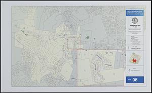
Boxborough, Middlesex County, Mass map 06
15.
[Buildout analysis] New Bedford, Massachusetts
16.
The Charles River basin
17.
The Charles River basin : hydrography, wetlands & protected open space in the basin
18.
City of Boston open space
19.
City of Boston planimetric survey sheet no. 23I
20.
City of Springfield
« Previous
Next »
1
2
3
4
5
…
7
8
Limit your search
Subject
Massachusetts--Maps
19
Dedham (Mass.)--Maps
4
Election districts--Massachusetts--Maps
4
Land use--Massachusetts--Maps
4
Massachusetts--Administrative and political divisions--Election districts--Maps
4
Massachusetts--Photomaps--Indexes
4
Mexico--Maps
4
Newton (Mass.)--Maps
4
more
Subject
»
Place
North and Central America
139
United States
135
Massachusetts
109
Middlesex (county)
17
Bristol (county)
9
Plymouth (county)
8
Suffolk (county)
7
Barnstable (county)
6
more
Place
»
Format
Maps/Atlases
149
Ephemera
1
Available to use
No known restrictions
150
Date
View distribution
Current results range from
1814
to
2010
Date range begin
Date range end
View larger »
Collection
Norman B. Leventhal Map & Education Center Collection
150
Applied Geographics, Inc. Records
143
Boston and New England Maps (Collection of Distinction)
117
Urban Maps (Collection of Distinction)
28
Maritime Charts and Atlases (Collection of Distinction)
17
Institution
Boston Public Library
150


![[Buildout analysis] New Bedford, Massachusetts](https://bpldcassets.blob.core.windows.net/derivatives/images/commonwealth:v405z947d/image_thumbnail_300.jpg)