221. Below, a pleasure boat is partially submerged at the South Boston Yacht Club. Format: Photographs Collection: Boston Herald-Traveler Photo Morgue Date: [ca. August 1971] Institution: Boston Public Library
222. Below, huge waves caused by big blow rip the boardwalk apart at Carolina Beach, N. C. Creator: Associated Press Format: Photographs Collection: Boston Herald-Traveler Photo Morgue Date: [ca. August 1955] Institution: Boston Public Library
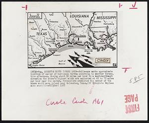
223. Bertha Moves Toward Land -- Bulls-eye marks approximate location of center of hurricane Bertha according to weather bureau, this afternoon. Moving about 10 miles per... Creator: Associated Press Format: Photographs Collection: Boston Herald-Traveler Photo Morgue Date: [ca. August 1957] Institution: Boston Public Library
224. Betsy. Format: Photographs Collection: Boston Herald-Traveler Photo Morgue Date: [ca. August 1965] Institution: Boston Public Library
225. Betsy. Format: Photographs Collection: Boston Herald-Traveler Photo Morgue Date: [ca. August 1955] Institution: Boston Public Library
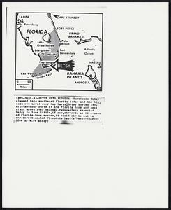
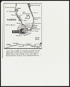
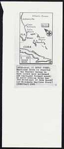
226. Betsy Hits Florida -- Hurricane Betsy slammed into southeast Florida today and the big calm eye moved over Key Largo, Betsy hurled 140-mile-an-hour gusts at the... Creator: Associated Press Format: Photographs Collection: Boston Herald-Traveler Photo Morgue Date: [ca. September 1965] Institution: Boston Public Library
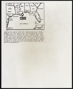
227. Betsy Hits New Orleans -- Hurricane Betsy slammed into New Orleans and the neighboring resorts of Mississippi’s plush Gulf coast tonight. More than 10,000 homes were... Creator: Associated Press Format: Photographs Collection: Boston Herald-Traveler Photo Morgue Date: [ca. September 1965] Institution: Boston Public Library
228. Betsy in Gulf -- Map locates current approximate position of Hurricane Betsy as it moves west of the Florida coast. Forecasters aren’t saying where it will hit next. Creator: Associated Press Format: Photographs Collection: Boston Herald-Traveler Photo Morgue Date: [ca. September 1965] Institution: Boston Public Library
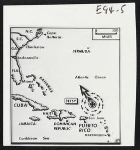
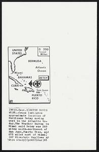
229. Betsy Moves West -- Cross indicates approximate location of Hurricane Betsy moving west in the Atlantic today. The Weather Bureau in Miami said Betsy was 260 miles... Creator: Associated Press Format: Photographs Collection: Boston Herald-Traveler Photo Morgue Date: [ca. September 1965] Institution: Boston Public Library
230. Betsy Nears Gulf Coast -- An emergency bulletin issued by the New Orleans weather bureau at 6 p.m., est, said the center of hurricane Betsy was located at about 150... Creator: Associated Press Format: Photographs Collection: Boston Herald-Traveler Photo Morgue Date: [ca. September 1965] Institution: Boston Public Library
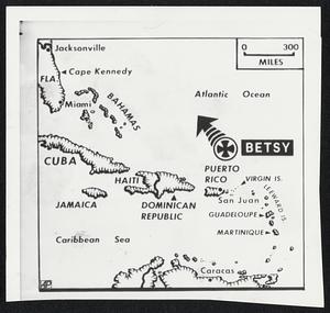
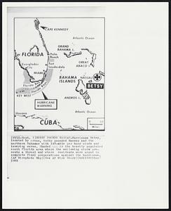
231. Betsy Pounds Nassau -- Hurricane Betsy, located by cross, today pounded Nassau and the northern Bahamas with 140-mile per hour winds and towering waves. Shaded is the... Creator: Associated Press Format: Photographs Collection: Boston Herald-Traveler Photo Morgue Date: [ca. September 1965] Institution: Boston Public Library
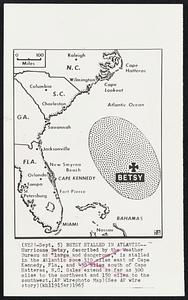
232. Betsy Stalled in Atlantic -- Hurricane Betsy, described by the Weather Bureau as “large and dangerous,” is stalled in the Atlantic some 310 miles east of Cape Kennedy,... Creator: Associated Press Format: Photographs Collection: Boston Herald-Traveler Photo Morgue Date: [ca. September 1965] Institution: Boston Public Library
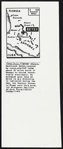
233. Betsy Stalls -- Hurricane Betsy, located by cross, stalled today about 30 miles north of Nassau to become essentially stationary. No movement more than 40 miles in any... Creator: Associated Press Format: Photographs Collection: Boston Herald-Traveler Photo Morgue Date: [ca. September 1965] Institution: Boston Public Library
234. Betsy Storms Ashore -- Hurricane Betsy, marked by cross, is over land but still packs winds of 100-miles-per-hour. Heavy rains and high winds will spread through... Creator: Associated Press Format: Photographs Collection: Boston Herald-Traveler Photo Morgue Date: [ca. September 1965] Institution: Boston Public Library
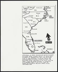
235. Betsy Stronger but Moving Slowly--Hurricane Betsy, located tonight 375 miles east-southeast of Jacksonville, Fla., and 450 miles south of Cape Hatteras, is moving... Creator: Associated Press Format: Photographs Collection: Boston Herald-Traveler Photo Morgue Date: [ca. September 1965] Institution: Boston Public Library
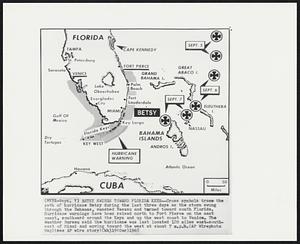
236. Betsy Swings Toward Florida Keys--Cross symbols trace the path of hurricane Betsy during the last three days as the storm swung through the Bahamas, smashed Nassau and... Creator: Associated Press Format: Photographs Collection: Boston Herald-Traveler Photo Morgue Date: [ca. September 1965] Institution: Boston Public Library
237. Betsy Turns -- Hurricane Betsy is reported by the Weather Bureau to have turned more northward and increased forward speed. At early evening Betsy was 340 miles east... Creator: Associated Press Format: Photographs Collection: Boston Herald-Traveler Photo Morgue Date: [ca. September 1965] Institution: Boston Public Library
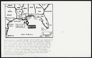
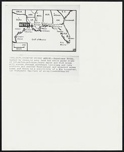
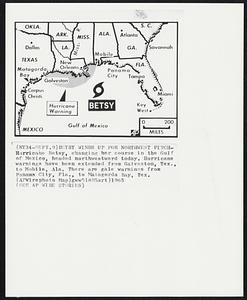
238. Betsy Winds Up For Northwest Pitch -- Hurricane Bets, changing her course in the Gulf of Mexico, headed northwestward today. Hurricane warnings have been extended from... Creator: Associated Press Format: Photographs Collection: Boston Herald-Traveler Photo Morgue Date: [ca. September 1965] Institution: Boston Public Library
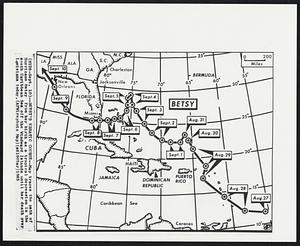
239. Betsy’s Erratic Course -- Map traces the path of Hurricane Betsy from her birth as a tropical depression in the south Caribbean Sea off the Windward Islands until her... Creator: Associated Press Format: Photographs Collection: Boston Herald-Traveler Photo Morgue Date: [ca. September 1965] Institution: Boston Public Library
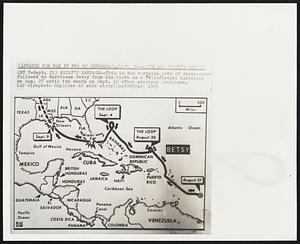
240. Betsy’s Rampage--This is the tortuous path of destruction followed by Hurricane Betsy from its birth as a full-fledged hurricane on Aug. 27 until its death on Sept. 10... Creator: Associated Press Format: Photographs Collection: Boston Herald-Traveler Photo Morgue Date: [ca. September 1965] Institution: Boston Public Library