Skip to search
Skip to main content
Skip to first result
Digital Commonwealth
Folders
Sign Up / Log In
Search for
Search
Search
Search
Basic
Advanced
Explore
Map
Collections
Institutions
Formats
For Educators
Primary Source Sets
Lesson Plans
Using Primary Sources
Searching Digital Commonwealth
For Institutions
Join Digital Commonwealth
Conferences, Trainings, & Events
How to Contribute Collections
Digitization Services
Board & Committees
Frequently Asked Questions
About
About Digital Commonwealth
News & Announcements
Copyright & Terms of Use
Harmful Content Statement
Partners
API
Contact Us
Search
Search Constraints
Start Over
Save Search
Your search:
More Like
commonwealth:z603vg18f
✖
Remove constraint More Like: commonwealth:z603vg18f
« Prev. |
1
-
20
of
172
|
Next »
Sort
by relevance
relevance
title
date (asc)
date (desc)
recently added
Number of results to display per page
20
per page
per page
10
per page
20
per page
50
per page
100
per page
View results as:
List
list view
Maps
map view
Gallery
grid view
Search Results
1.
Carte de la Louisiane et de la Floride
2.
Carte de la Floride, de la Louisiane, et pays voisins. : Pour servir à l'Histoire générale des voyages
3.
A Map of the new governments, of East & West Florida
4.
Map of the province of West Florida
5.
A new & accurate map of Louisiana, with part of Florida and Canada, : and the adjacent countries drawn from surveys assisted by...
6.
The peninsula and Gulf of Florida, or New Bahama Channel, : with the Bahama Island
7.
Carolinae Floridae nec non insularum Bahamensium : cum partibus adjacendibus delineatio ad Exemplar Londinense in lucem edita a...
8.
A new chart of America : with the harbors, of Port Royal and Savannah &c
9.
Chart of the West Indies and Spanish Dominions in North America
10.
Colton's Florida
11.
Florida gebiet
12.
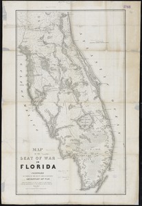
Map of the seat of war in Florida
13.
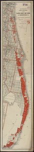
Map showing the lands & waterway of the Florida Coast Line Canal & Transportation Co
14.
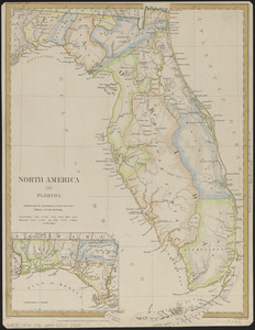
North America : Florida
15.
Northern part of Florida
16.
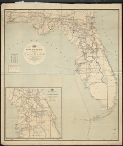
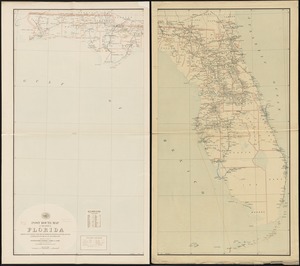
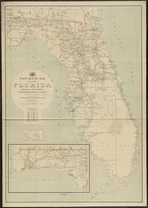
Post route map of the State of Florida showing post offices with the intermediate distances and mail routes in operation on the...
17.
Post route map of the state of Florida showing post offices with the intermediate distances and mail routes in operation on the...
18.
Post route map of the state of Florida showing post offices with the intermediate distances on mail routes in operation on the...
19.
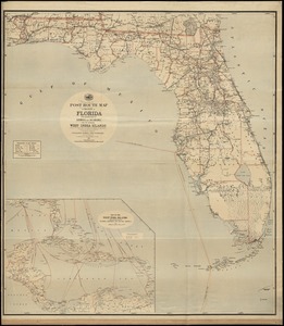
Post route map of the State of Florida with adjacent parts of Georgia and Alabama also the neighboring West India Islands...
20.
Southern Railway system
« Previous
Next »
1
2
3
4
5
…
8
9
Limit your search
Subject
Southern States--Maps
22
Florida--Maps
21
United States--Maps
20
West Indies--Maps
19
North America--Maps
17
Canada--Maps
14
Boston (Mass.)--Maps
9
New England--Maps
9
more
Subject
»
Place
North and Central America
136
United States
81
Canada
22
Southern United States
20
Florida
19
West Indies
19
North America
17
New York
11
more
Place
»
Format
Maps/Atlases
172
Manuscripts
12
Available to use
No known restrictions
34
Creative Commons license
1
Date
View distribution
Current results range from
1750
to
1978
Date range begin
Date range end
View larger »
Collection
American Antiquarian Society Collection
138
American Revolutionary War-Era Maps (Collection of Distinction)
137
Norman B. Leventhal Map & Education Center Collection
34
Boston and New England Maps (Collection of Distinction)
1
Maritime Charts and Atlases (Collection of Distinction)
1
Institution
American Antiquarian Society
138
Boston Public Library
34